yoda
-
Posts
63,541 -
Joined
Content Type
Profiles
Blogs
Forums
American Weather
Media Demo
Store
Gallery
Everything posted by yoda
-
URGENT - WINTER WEATHER MESSAGE National Weather Service Baltimore MD/Washington DC 257 AM EST Sat Jan 30 2021 MDZ006-008-011-507-508-301600- /O.CON.KLWX.WS.A.0002.210131T1100Z-210201T1100Z/ Northern Baltimore-Cecil-Southern Baltimore-Northwest Harford- Southeast Harford- 257 AM EST Sat Jan 30 2021 ...WINTER STORM WATCH REMAINS IN EFFECT FROM SUNDAY MORNING THROUGH LATE SUNDAY NIGHT... * WHAT...Heavy mixed precipitation possible. Total snow accumulations of 4 to 6 inches and ice accumulations of around one tenth of an inch possible. Winds could gust as high as 35 mph. * WHERE...Northern Baltimore, Cecil, Southeast Harford, Southern Baltimore and Northwest Harford Counties. * WHEN...From Sunday morning through late Sunday night. * IMPACTS...Plan on slippery road conditions. The hazardous conditions could impact the morning commute.
-
URGENT - WINTER WEATHER MESSAGE National Weather Service Baltimore MD/Washington DC 257 AM EST Sat Jan 30 2021 MDZ001-VAZ025>027-029-036>039-503-504-507-508-WVZ055-501>503-505- 506-301600- /O.CON.KLWX.WS.A.0002.210131T0300Z-210201T0300Z/ Garrett-Augusta-Rockingham-Shenandoah-Page-Nelson-Albemarle- Greene-Madison-Western Highland-Eastern Highland- Northern Virginia Blue Ridge-Central Virginia Blue Ridge-Hardy- Western Grant-Eastern Grant-Western Mineral-Western Pendleton- Eastern Pendleton- 257 AM EST Sat Jan 30 2021 ...WINTER STORM WATCH REMAINS IN EFFECT FROM THIS EVENING THROUGH SUNDAY EVENING... * WHAT...Heavy mixed precipitation possible. Total snow accumulations of 5 to 7 inches and ice accumulations of up to one tenth of an inch possible. * WHERE...Portions of central and western Virginia and eastern West Virginia. * WHEN...From Saturday evening through Sunday evening. * IMPACTS...Travel could be very difficult.
-
I added the first group just after you quoted my original post which only had the 2nd fyi
-
I will take you to Jabba now... er.. show you the EPS members now
-
@jayyy @psuhoffman There are around 11 or 12 monster hits in the EPS tonight FYI ETA: I consider "monster" to be around 16 inches or more
-
9 inches at DCA on the 00z EPS mean lol
-

Feb Long Range Discussion (Day 3 and beyond) - MERGED
yoda replied to WinterWxLuvr's topic in Mid Atlantic
There is a Day 9 event on the Euro tonight FWIW -
Well if we go that route, FWIW, the GEPS mean was 0.3 to 0.5" wetter on 00z than 18z
-
Guess we'll see what happens on the 00z EPS... though I think we are just about too close in now for it
-
Seems you and @psuhoffman are on agreement on that... which is good lol
-
Yes... I mean as I have said before I would love 12".... but I just want to see that WSWarning issued... 4" is my benchmark
-
Well PSU got harping on suppress... and this evening they have almost all besides UKIE went north
-
994mb SLP just east of Ocean City, MD at 72
-
Looks like a lil better ridging out west at 00z 36 compared to 12z 48 to me... yes?
-
00z EURO at 24 -- 998mb SLP in C MO
-
well 00z euro has started... may the odds be ever in our favor
-
00z increased up to 0.5" in part of our forum lol over 12z
-
Probably in to close, but FWIW, GEPS mean went up 2-4" area wide at 00z compared to 12z
-
For real tonight though... the biggest EURO run EVER
-
lol Hypo moved up to the Philly forum to make his troll posts
-
-
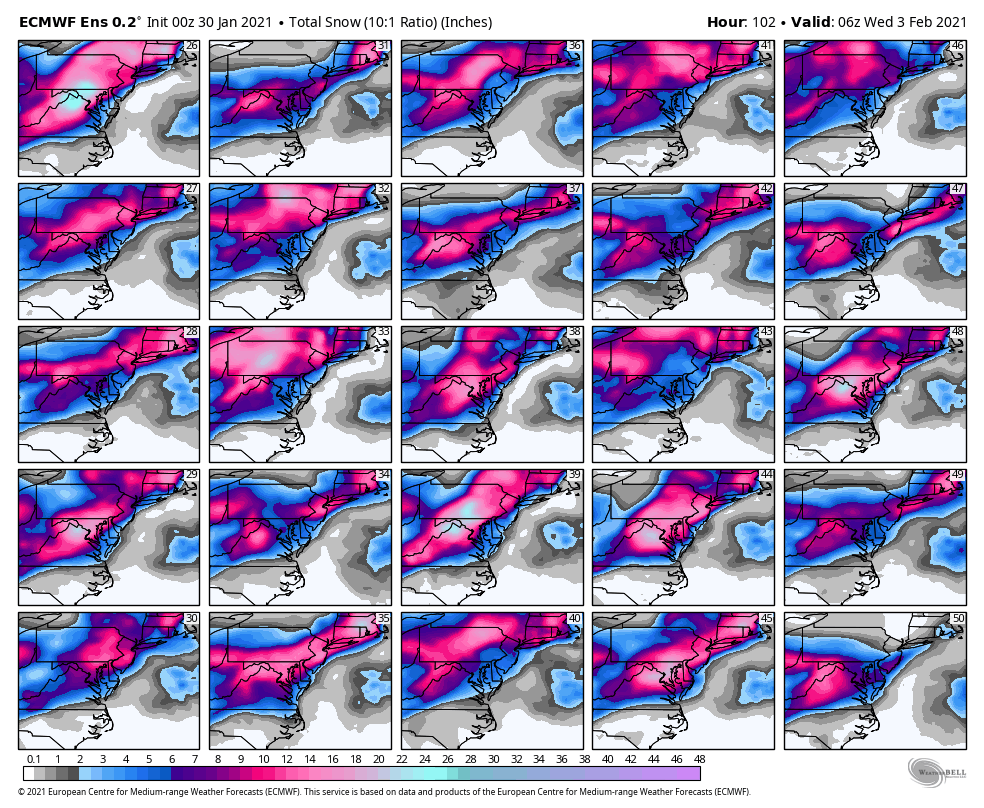
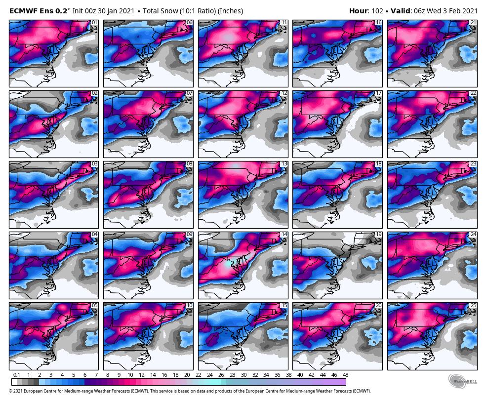
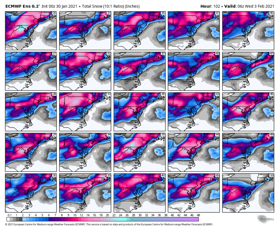
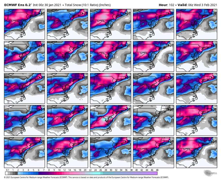
zoomed in Kuchera through 102
-
CMC precip type map https://collaboration.cmc.ec.gc.ca/cmc/cmdn/pcpn_type/pcpn_type_gem_reg.html
-
hours 64 to 78 look nice on the CCB
-
00z CMC looking good