yoda
-
Posts
60,268 -
Joined
Content Type
Profiles
Blogs
Forums
American Weather
Media Demo
Store
Gallery
Everything posted by yoda
-
Hmmm... new Day 1 is 15 hail and 15 wind... all of LWX CWA is in SLGT... hatched hail is off in the Ohio Valley... but disco seems to imply it could get moved eastward some later today... also seems to imply a 1-2 punch for us - afternoon risk and then nocturnal threat
-
I'm watching Season 2 of Star Trek Discovery... i like it so far
-
Alright... who broke the sensor?
-
https://www.google.com/amp/s/amp.usatoday.com/amp/5100853002 https://earthquake.usgs.gov/earthquakes/eventpage/us70008jr5/executive
-
Big earthquake earlier this evening in ID... 2nd biggest on record I believe in that state... 6.5 magnitude
-
Which will likely be quite a while unfortunately... I miss thunderstorms
-
Trying again north of Richmond
-
Looks like CI trying hard NE of Farmville... but got smushed lol
-
Figured we should bump this thread since we are discussing drought conditions again already in the main thread lol
-
I don't see that?
-
That's okay... I'll skip it lol... I mean, you had to get lucky sometime. Beating you in the 2nd round over and over did get a little bit boring after a while
-
The 2008 one? That was the first one and a good game. Won't spoil the ending
-
Um okay... that escalated quickly in the evening AFD
-
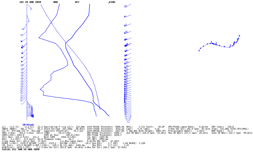
00z NAM still has some decent looking soundings at 21z tomorrow around the region
-
Spotters reported funnel cloud near Independence, IA
-
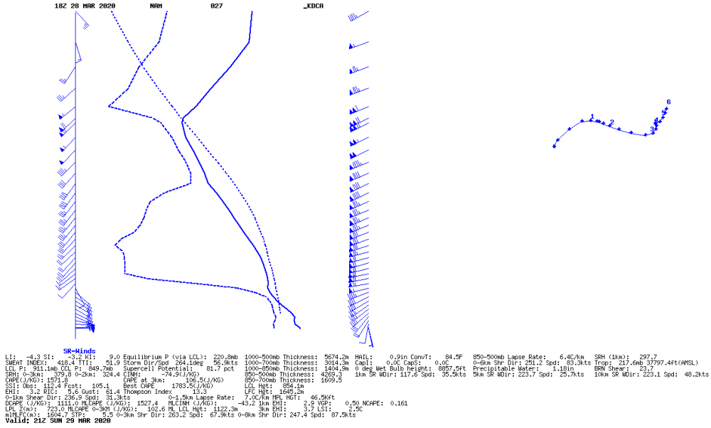
DCA sounding at 21z tomorrow per 18z NAM
-
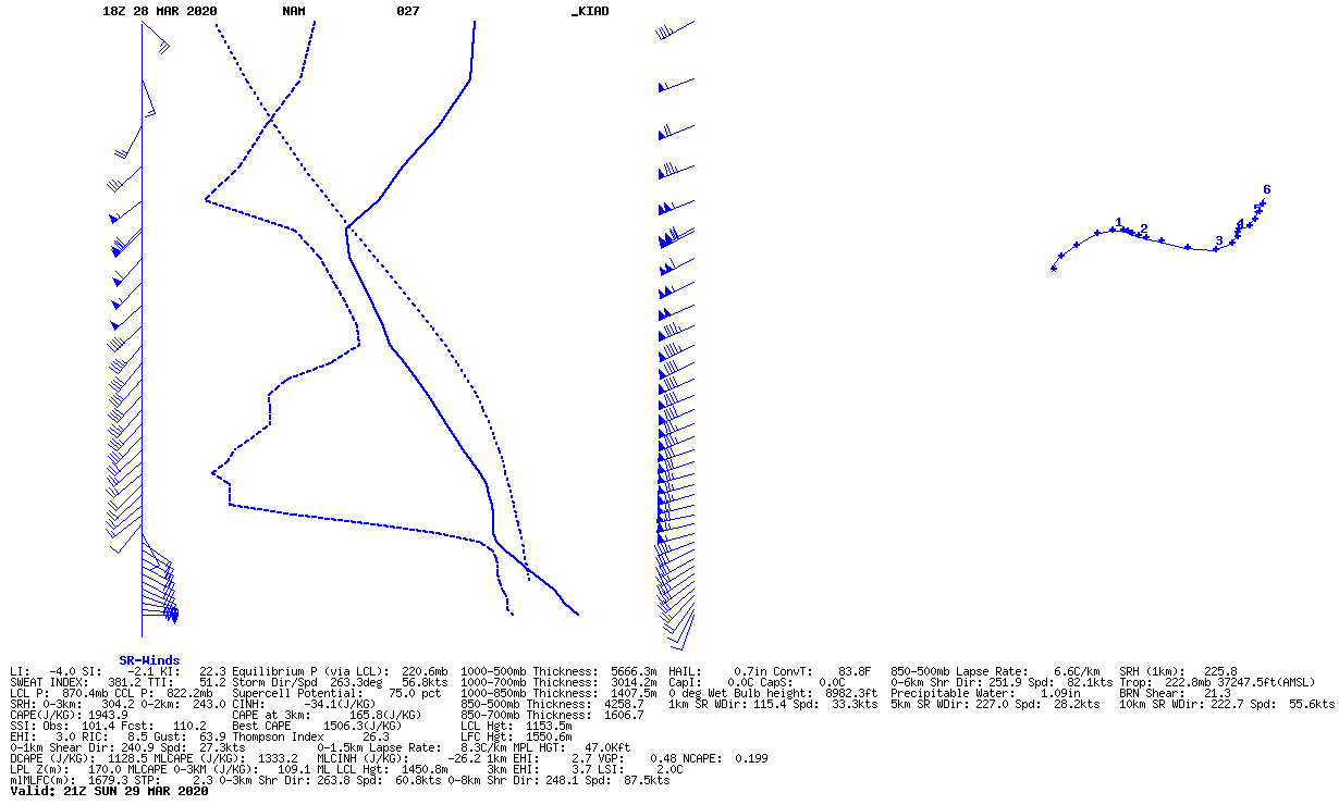
@high risk Pretty decent sounding from the 18z NAM for 21z tomorrow at KIAD, no?
-
BULLETIN - EAS ACTIVATION REQUESTED Tornado Warning National Weather Service Des Moines IA 438 PM CDT Sat Mar 28 2020 The National Weather Service in Des Moines has issued a * Tornado Warning for... Northwestern Marshall County in central Iowa... * Until 500 PM CDT. * At 437 PM CDT, a severe thunderstorm capable of producing a tornado was located over State Center, or 12 miles west of Marshalltown, moving north at 40 mph. HAZARD...Tornado. SOURCE...Weather spotters reported a rotating wall cloud at 435pm between Marshalltown and State Center. IMPACT...Flying debris will be dangerous to those caught without shelter. Mobile homes will be damaged or destroyed. Damage to roofs, windows, and vehicles will occur. Tree damage is likely. * This tornadic thunderstorm will remain over mainly rural areas of northwestern Marshall County, including the following locations... Clemons and Liscomb.
-
Also, radar confirmed TOG near Algoa, AR Severe Weather Statement National Weather Service Memphis TN 423 PM CDT Sat Mar 28 2020 ARC031-111-282145- /O.CON.KMEG.TO.W.0014.000000T0000Z-200328T2145Z/ Craighead AR-Poinsett AR- 423 PM CDT Sat Mar 28 2020 ...A TORNADO WARNING REMAINS IN EFFECT UNTIL 445 PM CDT FOR SOUTHWESTERN CRAIGHEAD AND NORTHWESTERN POINSETT COUNTIES... At 423 PM CDT, a confirmed tornado was located near Algoa, or 9 miles southeast of Newport, moving northeast at 40 mph. HAZARD...Damaging tornado. SOURCE...Radar confirmed tornado. IMPACT...Flying debris will be dangerous to those caught without shelter. Mobile homes will be damaged or destroyed. Damage to roofs, windows, and vehicles will occur. Tree damage is likely. Locations impacted include... Weiner, Cash, Waldenburg, Pitts, Risher, Uno, Otwell and Bayou De View State Wildlife Management Area. PRECAUTIONARY/PREPAREDNESS ACTIONS... To repeat, a tornado is on the ground. TAKE COVER NOW! Move to a storm shelter or an interior room on the lowest floor of a sturdy building. Avoid windows. If you are outdoors, in a mobile home, or in a vehicle, move to the closest substantial shelter and protect yourself from flying debris. && LAT...LON 3569 9104 3582 9091 3567 9073 3550 9104 TIME...MOT...LOC 2123Z 225DEG 33KT 3556 9109 TORNADO...OBSERVED HAIL...<.75IN
-
Severe Weather Statement National Weather Service Little Rock AR 424 PM CDT Sat Mar 28 2020 ARC067-282145- /O.CON.KLZK.TO.W.0022.000000T0000Z-200328T2145Z/ Jackson AR- 424 PM CDT Sat Mar 28 2020 ...A TORNADO WARNING REMAINS IN EFFECT UNTIL 445 PM CDT FOR EAST CENTRAL JACKSON COUNTY... At 423 PM CDT, a confirmed large and extremely dangerous tornado was located near Algoa, or 10 miles southeast of Newport, moving northeast at 40 mph. Radar detected a debris lofted ten thousand feet in the air in northeastern Jackson County near Balch. If you are near this storm, seek shelter immediately! Radar indicates a large and damaging tornado in the area. This is a PARTICULARLY DANGEROUS SITUATION. TAKE COVER NOW! HAZARD...Damaging tornado. SOURCE...Radar confirmed tornado. IMPACT...You are in a life-threatening situation. Flying debris may be deadly to those caught without shelter. Mobile homes will be destroyed. Considerable damage to homes, businesses, and vehicles is likely and complete destruction is possible. Locations impacted include... Grubbs... Amagon... Balch... PRECAUTIONARY/PREPAREDNESS ACTIONS... To repeat, a large, extremely dangerous and potentially deadly tornado is on the ground. To protect your life, TAKE COVER NOW! Move to a basement or an interior room on the lowest floor of a sturdy building. Avoid windows. If you are outdoors, in a mobile home, or in a vehicle, move to the closest substantial shelter and protect yourself from flying debris
-
Uh... radar detected 10k foot debris ball near Balch, AR...
-
Blackville (yes, that's the city name) looks to take a direct hit from that storm
-
Wall cloud reported by spotters near Mitchellville in IA BULLETIN - EAS ACTIVATION REQUESTED Tornado Warning National Weather Service Des Moines IA 410 PM CDT Sat Mar 28 2020 The National Weather Service in Des Moines has issued a * Tornado Warning for... Southeastern Story County in central Iowa... Southwestern Marshall County in central Iowa... Northwestern Jasper County in central Iowa... * Until 445 PM CDT. * At 409 PM CDT, a severe thunderstorm capable of producing a tornado was located near Colfax, or 11 miles northeast of Altoona, moving northeast at 50 mph. HAZARD...Tornado. SOURCE...Weather spotters reported a wall cloud near or just northeast of Mitchellville cloud. IMPACT...Flying debris will be dangerous to those caught without shelter. Mobile homes will be damaged or destroyed. Damage to roofs, windows, and vehicles will occur. Tree damage is likely. * This dangerous storm will be near... Baxter around 420 PM CDT. Other locations impacted by this tornadic thunderstorm include Valeria, Rhodes, Mingo and Melbourne. PRECAUTIONARY/PREPAREDNESS ACTIONS... TAKE COVER NOW! Move to a basement or an interior room on the lowest floor of a sturdy building. Avoid windows. If you are outdoors, in a mobile home, or in a vehicle, move to the closest substantial shelter and protect yourself from flying debris.
-
Mod risk remains at 20z
-
Tor probs are 90/80