yoda
-
Posts
60,268 -
Joined
Content Type
Profiles
Blogs
Forums
American Weather
Media Demo
Store
Gallery
Everything posted by yoda
-
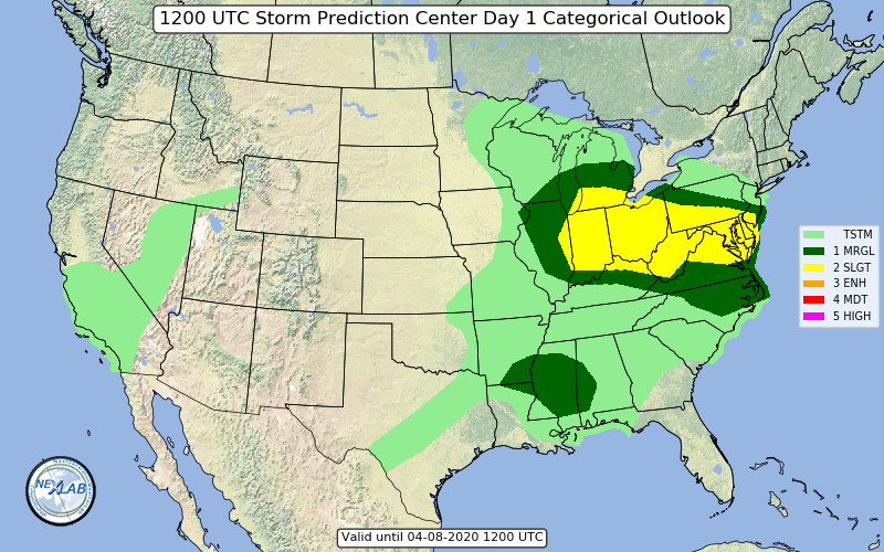
and later today from new Day 1 SPC OTLK
-
For overnight Mesoscale Discussion 0321 NWS Storm Prediction Center Norman OK 1150 PM CDT Wed Apr 08 2020 Areas affected...West Virginia into western Virginia Concerning...Severe potential...Watch possible Valid 090450Z - 090645Z Probability of Watch Issuance...40 percent SUMMARY...A line of severe storms may still be severe as it approaches the eastern parts of Tornado Watch 93. DISCUSSION...A strongly forced line of storms with history of damaging winds continues rapidly eastward at over 50 kt. VWPs ahead of the line indicate modest southwesterly winds just off the surface, which is helping to increase moisture and instability values to the east, and despite relatively cooler surface temperatures. Despite marginal instability, the high level of organization suggests some chance of continued severe wind threat as the line approaches eastern WV and possibly across the VA border. Trends will continue to be monitored, and another watch may need to be considered. ..Jewell/Hart.. 04/09/2020 ...Please see www.spc.noaa.gov for graphic product... ATTN...WFO...LWX...RNK...PBZ...RLX...
-
Probably not going to be severe by time it reaches us... but SPC just issued a Tornado Watch till 4am for a good amount of counties in West Virginia and pushes into the central portion of West Virginia https://www.spc.noaa.gov/products/watch/ww0093.html
-
Hmmmm... LWX seems to think there will be a chance for some severe late tonight in the form of damaging winds out in the western part of the forum with wording in the zones and updated evening AFD:
-
Severe Thunderstorm Warning MDC003-005-013-021-025-027-510-080830- /O.NEW.KLWX.SV.W.0031.200408T0753Z-200408T0830Z/ BULLETIN - IMMEDIATE BROADCAST REQUESTED Severe Thunderstorm Warning National Weather Service Baltimore MD/Washington DC 353 AM EDT Wed Apr 8 2020 The National Weather Service in Sterling Virginia has issued a * Severe Thunderstorm Warning for... Southeastern Carroll County in north central Maryland... Baltimore City in northern Maryland... North central Anne Arundel County in central Maryland... Howard County in central Maryland... Southwestern Harford County in northern Maryland... East central Frederick County in north central Maryland... Baltimore County in northern Maryland... * Until 430 AM EDT. * At 353 AM EDT, severe thunderstorms were located along a line extending from near Hampstead to near Gamber to Mount Airy, moving southeast at 45 mph. HAZARD...60 mph wind gusts and quarter size hail. SOURCE...Radar indicated. IMPACT...Damaging winds will cause some trees and large branches to fall. This could injure those outdoors, as well as damage homes and vehicles. Roadways may become blocked by downed trees. Localized power outages are possible. Unsecured light objects may become projectiles. * Locations impacted include... Baltimore, Columbia, Pikesville, Middle River, Cockeysville, Elkridge, Riviera Beach, Millers Island, North Point State Park, Sparrows Point, Back River, Historic Ellicott City, Glen Burnie, Ellicott City, Dundalk, Towson, Catonsville, Essex, Woodlawn and Randallstown. PRECAUTIONARY/PREPAREDNESS ACTIONS... For your protection move to an interior room on the lowest floor of a building. && LAT...LON 3931 7629 3933 7631 3925 7638 3919 7647 3920 7650 3918 7648 3917 7650 3918 7694 3928 7710 3939 7722 3947 7701 3963 7686 3958 7659 3938 7618 TIME...MOT...LOC 0753Z 303DEG 41KT 3958 7688 3945 7697 3938 7715 HAIL...1.00IN WIND...60MPH
-
Kinda looks like the line is intensifying as it approaches DC metro... with maybe a slight bow?
-
Good morning everyone Severe Thunderstorm Warning MDC013-021-031-043-VAC043-069-107-WVC037-080830- /O.NEW.KLWX.SV.W.0030.200408T0743Z-200408T0830Z/ BULLETIN - IMMEDIATE BROADCAST REQUESTED Severe Thunderstorm Warning National Weather Service Baltimore MD/Washington DC 343 AM EDT Wed Apr 8 2020 The National Weather Service in Sterling Virginia has issued a * Severe Thunderstorm Warning for... Southeastern Washington County in north central Maryland... Southwestern Carroll County in north central Maryland... Western Montgomery County in central Maryland... Southern Frederick County in north central Maryland... Loudoun County in northern Virginia... Eastern Frederick County in northwestern Virginia... Central Clarke County in northwestern Virginia... Southern Jefferson County in the Panhandle of West Virginia... * Until 430 AM EDT. * At 343 AM EDT, severe thunderstorms were located along a line extending from Clover Hill to 6 miles southwest of Brunswick to near Berryville, moving southeast at 60 mph. HAZARD...60 mph wind gusts and quarter size hail. SOURCE...Radar indicated. IMPACT...Damaging winds will cause some trees and large branches to fall. This could injure those outdoors, as well as damage homes and vehicles. Roadways may become blocked by downed trees. Localized power outages are possible. Unsecured light objects may become projectiles. * Locations impacted include... Germantown, Frederick, Gaithersburg, Leesburg, South Riding, Damascus, Broadlands, Lansdowne, Lowes Island, Brambleton, Poolesville, Harry Grove Stadium, Ashburn, Montgomery Village, Sterling, North Potomac, Ballenger Creek, Countryside, Mount Airy and Purcellville. PRECAUTIONARY/PREPAREDNESS ACTIONS... For your protection move to an interior room on the lowest floor of a building. && LAT...LON 3941 7717 3935 7714 3935 7717 3934 7719 3925 7710 3903 7726 3906 7733 3898 7741 3891 7760 3894 7764 3899 7786 3920 7808 3927 7775 3950 7749 TIME...MOT...LOC 0743Z 304DEG 51KT 3944 7746 3924 7769 3919 7793 HAIL...1.00IN WIND...60MPH
-
New day 2 from SPC was quite meh unfortunately
-
Ah... so the drought didnt follow you on your move lol
-
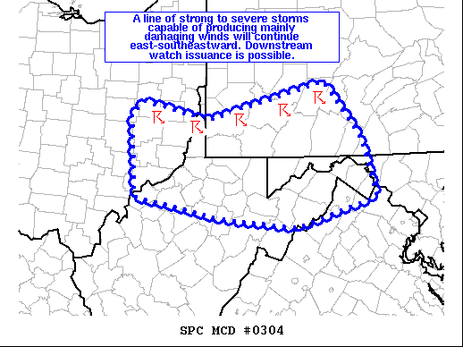
https://www.spc.noaa.gov/products/md/md0304.html Mesoscale Discussion 0304 NWS Storm Prediction Center Norman OK 1252 AM CDT Wed Apr 08 2020 Areas affected...Portions of southeastern OH...northern WV...southwestern PA...western MD...and far northern VA Concerning...Severe Thunderstorm Watch 85... Valid 080552Z - 080715Z The severe weather threat for Severe Thunderstorm Watch 85 continues. SUMMARY...A line of strong to severe storms capable of producing mainly damaging winds will continue east-southeastward. Downstream watch issuance is possible. DISCUSSION...Storms have grown upscale across parts of southeastern OH into western PA, with mainly severe/damaging winds being reported, including a gust to 75 mph at the Pittsburgh International Airport. The airmass downstream of this ongoing convection is not particularly unstable given cooler low-level temperatures and less low-level moisture. With MUCAPE generally 500-1000 J/kg, storms may have a tendency to become slightly elevated with time, particularly with eastward extent. Still, given the well-organized nature of the line and strong outbound velocities noted on KPBZ radar, there appears to be a continued strong to damaging wind threat that may extend to the south/southeast of ongoing Severe Thunderstorm Watch 85. Accordingly, another watch may be needed across parts of southwestern PA into western MD and the eastern WV Panhandle. ..Gleason/Thompson.. 04/08/2020 ...Please see www.spc.noaa.gov for graphic product... ATTN...WFO...CTP...LWX...PBZ...RLX...
-
Wow... impressive PRELIMINARY LOCAL STORM REPORT NATIONAL WEATHER SERVICE BALTIMORE MD/WASHINGTON DC 1140 PM EDT TUE APR 07 2020 ..TIME... ...EVENT... ...CITY LOCATION... ...LAT.LON... ..DATE... ....MAG.... ..COUNTY LOCATION..ST.. ...SOURCE.... ..REMARKS.. 1019 PM HAIL SPOTTSWOOD 37.95N 79.21W 04/07/2020 E1.00 INCH AUGUSTA VA 911 CALL CENTER HAIL ACCUMULATING 2 INCHES DEEP ON I-81 NEAR SPOTSWOOD CAUSED MULTIPLE ACCIDENTS AND PARTIALLY CLOSED THE HIGHWAY && EVENT NUMBER LWX2000890
-
LWX evening AFD update agrees with you
-
URGENT - IMMEDIATE BROADCAST REQUESTED Severe Thunderstorm Watch Number 84 NWS Storm Prediction Center Norman OK 905 PM EDT Tue Apr 7 2020 The NWS Storm Prediction Center has issued a * Severe Thunderstorm Watch for portions of Northern Indiana Far southern Lower Michigan Northern Ohio Northwest Pennsylvania Lake Erie Lake Michigan * Effective this Tuesday night and Wednesday morning from 905 PM until 300 AM EDT. * Primary threats include... Scattered damaging winds likely with isolated significant gusts to 75 mph possible Scattered large hail likely with isolated very large hail events to 2.5 inches in diameter possible A tornado or two possible SUMMARY...Multiple clusters of supercells will evolve east-southeast tonight with development into a broader MCS expected. A mix of large hail and damaging wind gusts appear probable. The severe thunderstorm watch area is approximately along and 60 statute miles north and south of a line from 20 miles south of Valparaiso IN to 35 miles north northeast of Youngstown OH. For a complete depiction of the watch see the associated watch outline update (WOUS64 KWNS WOU4). PRECAUTIONARY/PREPAREDNESS ACTIONS... REMEMBER...A Severe Thunderstorm Watch means conditions are favorable for severe thunderstorms in and close to the watch area. Persons in these areas should be on the lookout for threatening weather conditions and listen for later statements and possible warnings. Severe thunderstorms can and occasionally do produce tornadoes.
-
STWatch issued until 3AM for where the MCS is developing back in OH and MI - https://www.spc.noaa.gov/products/watch/ww0084.html
-
Its coming... just got issued... severe thunderstorm watch that is
-
0100 SPC OTLK mentions MCS complex rolling through overnight with large hail and damaging winds as a threat
-
LWX states spotter activation maybe needed overnight in their updated HWO Also zones have severe wording in them for overnight and tomorrow morning
-
Big hail core in the supercell in N WV right now
-
https://www.spc.noaa.gov/products/md/md0295.html
-
Mesoscale Discussion 0295 NWS Storm Prediction Center Norman OK 0306 PM CDT Tue Apr 07 2020 Areas affected...eastern WI...northern IL/IN and western MI Concerning...Severe potential...Watch likely Valid 072006Z - 072200Z Probability of Watch Issuance...80 percent SUMMARY...Isolated elevated thunderstorms may produce large hail across eastern WI near Green Bay over the next hour. Additional storms are expected to develop further south over the next couple of hours, posing a threat for damaging wind gusts, large hail and perhaps a couple of tornadoes, while spreading eastward across southern Lower Michigan/northern Indiana this evening. DISCUSSION...Isolated elevated thunderstorms have developed north of the warm front. Very steep midlevel lapse rates and strong shear will support large hail potential in this elevated convection. Further south, strong warm advection is resulting in modest increases in boundary layer moisture south of the warm front, with dewpoints mainly in the mid-50s to near 60 F south of the boundary. Very steep lapse rates atop a weakening capping inversion and strong vertical shear will favor semi-discrete cells capable of large hail initially. Strong heating into the low and mid 70s is aiding in rapid erosion of this cap. As a result, expect isolated to widely-scattered surface-based thunderstorm development over the next couple of hours across southeast WI. In addition to damaging wind and large hail, a couple of tornadoes are possible, especially in the vicinity of the warm front where low level shear is enhanced. With time and as frontal forcing increases this evening in conjunction with a low level jet, convection will likely grow upscale into one or more bowing segments as storms shift east over Lake Michigan and into southern Lower Michigan toward 00z. This will increase potential for damaging winds across parts of southern Lower Michigan into northern Indiana this evening. ..Leitman/Hart.. 04/07/2020 ...Please see www.spc.noaa.gov for graphic product... ATTN...WFO...DTX...APX...IWX...GRR...GRB...LOT...MKX...
-
2000 SPC OTLK states that threat for severe hail and wind should increase as diurnal heating continues and references the MCD Eskimo Joe posted above
-
Looks like the sun is trying hard to come back out here
-
LWX afternoon AFD seems to think 2 more rounds to go... one this evening and one overnight
-
-