


yoda
-
Posts
64,053 -
Joined
Content Type
Profiles
Blogs
Forums
American Weather
Media Demo
Store
Gallery
Everything posted by yoda
-
18z NAM sim reflectivity shows a pretty strong line of storms pushing through as an Ida finale at 00z Thursday
-
Pretty impressive soundings at KIAD and KDCA based off the image lol... 45 to 50 kts 0-6km shear and nice hodo along with impressive low level shear Same at KEZF and KBWI
-
Does slightly look like Isabel tbh at first glance lol
-
 Tropical Storm Kate Discussion Number 11 NWS National Hurricane Center Miami FL AL102021 500 PM AST Mon Aug 30 2021 The low-level center of Kate is exposed in visible satellite imagery this afternoon. Its deep convection collapsed late this morning, and the sheared tropical cyclone is now only producing a small area of convection over 60 n mi east of its center. A partial 1321 UTC ASCAT-B pass still showed numerous 30-kt wind vectors in the eastern semicircle, even with little to no active convection. The initial intensity is conservatively lowered to 35 kt for this advisory. The subtropical jet stream across the central Atlantic will continue to impart strong west-northwesterly vertical wind shear on Kate during the next day or so. If the struggling tropical cyclone can survive these hostile conditions, some modest strengthening could occur later this week over warm SSTs of 28 deg C or so. However, the lack of mid-level moisture in the surrounding environment may limit convective development even under these more favorable conditions, and there is no guarantee that Kate will survive that long. In fact, simulated satellite imagery from the GFS and ECMWF suggest that Kate may continue to only produce sporadic bursts of convection over the next couple of days, which jeopardizes its chances of surviving through the week. The official NHC intensity forecast has been adjusted downward based on the latest guidance trends and the uncertainties discussed above. Minor fluctuations in intensity could occur over the next 24-36 h as convective pulsing causes the cyclone's intensity to hover around tropical-storm-force strength. Kate is moving a little faster toward the north, or 355/9 kt, within a weakness in the subtropical ridge. A northward motion is expected to continue through early Tuesday. The subtropical ridge is expected to become reestablished over the central Atlantic Tuesday night into Wednesday, which should turn Kate toward the northwest through midweek. Thereafter, Kate is forecast to accelerate northward or north-northeastward ahead of an approaching deep-layer trough that will move across the western Atlantic late this week. Assuming Kate is still around by day 5, the cyclone is forecast to become absorbed by a larger extratropical low near Atlantic Canada. FORECAST POSITIONS AND MAX WINDS INIT 30/2100Z 22.7N 50.9W 35 KT 40 MPH 12H 31/0600Z 23.7N 50.7W 30 KT 35 MPH 24H 31/1800Z 24.7N 50.7W 30 KT 35 MPH 36H 01/0600Z 25.8N 51.1W 35 KT 40 MPH 48H 01/1800Z 27.0N 52.1W 35 KT 40 MPH 60H 02/0600Z 28.4N 53.5W 40 KT 45 MPH 72H 02/1800Z 30.1N 54.7W 40 KT 45 MPH 96H 03/1800Z 34.5N 55.0W 40 KT 45 MPH 120H 04/1800Z...DISSIPATED $$ Forecaster Reinhart
 -
Tropical Storm Kate Advisory Number 11 NWS National Hurricane Center Miami FL AL102021 500 PM AST Mon Aug 30 2021 ...KATE REMAINS A SHEARED TROPICAL CYCLONE OVER THE OPEN WATERS OF THE CENTRAL ATLANTIC... SUMMARY OF 500 PM AST...2100 UTC...INFORMATION ---------------------------------------------- LOCATION...22.7N 50.9W ABOUT 805 MI...1295 KM ENE OF THE LEEWARD ISLANDS MAXIMUM SUSTAINED WINDS...40 MPH...65 KM/H PRESENT MOVEMENT...N OR 355 DEGREES AT 10 MPH...17 KM/H MINIMUM CENTRAL PRESSURE...1006 MB...29.71 INCHES WATCHES AND WARNINGS -------------------- There are no coastal watches or warnings in effect. DISCUSSION AND OUTLOOK ---------------------- At 500 PM AST (2100 UTC), the center of Tropical Storm Kate was located near latitude 22.7 North, longitude 50.9 West. Kate is moving toward the north near 10 mph (17 km/h), and this motion with a slight decrease in forward speed is expected through early Tuesday. Then, a northwestward motion is forecast through midweek. Maximum sustained winds have decreased to near 40 mph (65 km/h) with higher gusts. Some fluctuations in intensity are forecast during the next couple of days. Some slow strengthening is possible by Thursday. Tropical-storm-force winds extend outward up to 45 miles (75 km) from the center in the eastern semicircle. The estimated minimum central pressure is 1006 mb (29.71 inches). HAZARDS AFFECTING LAND ---------------------- None. NEXT ADVISORY ------------- Next complete advisory at 1100 PM AST. $$ Forecaster Reinhart
-
@WxWatcher007 I assume that the Hurricane that the 12z Euro shows heading WNW at the end if its run is about to be kicked and recurve back out to sea due to the incoming trough, yes?
-
12z NAM soundings look nice as well
-
I'm intrigued for Tuesday night into early Wednesday... MRGL risk for isolated tornadoes and damaging wind gusts
-
That would mean better chance of severe weather
-
@psuhoffman is fringed... I think?
-
My job is done
-
@EastCoast NPZ Hmmm
-
National Weather Service Baltimore MD/Washington DC 454 AM EDT Mon Aug 30 2021 DCZ001-MDZ004>006-008-011-013-014-503>508-VAZ038>040-051>054-501-502- 505>507-301700- /O.NEW.KLWX.FF.A.0014.210901T1500Z-210902T1200Z/ /00000.0.ER.000000T0000Z.000000T0000Z.000000T0000Z.OO/ District of Columbia-Frederick MD-Carroll-Northern Baltimore-Cecil- Southern Baltimore-Prince Georges-Anne Arundel-Northwest Montgomery- Central and Southeast Montgomery-Northwest Howard-Central and Southeast Howard-Northwest Harford-Southeast Harford-Greene-Madison- Rappahannock-Culpeper-Prince William/Manassas/Manassas Park-Fairfax- Arlington/Falls Church/Alexandria-Northern Fauquier-Southern Fauquier-Western Loudoun-Eastern Loudoun-Northern Virginia Blue Ridge- Including the cities of Elkton, South Gate, Bowie, Arlington, Annapolis, Manassas, Odenton, Westminster, Damascus, Falls Church, Silver Spring, Purcellville, Bethesda, Chantilly, Culpeper, Ballenger Creek, Centreville, Sterling, College Park, Reisterstown, Columbia, Warrenton, Herndon, Alexandria, Severna Park, Greenbelt, Germantown, Leesburg, McLean, Camp Springs, Rockville, Jarrettsville, Frederick, Arnold, Dale City, Big Meadows, Suitland-Silver Hill, Lake Ridge, Gaithersburg, Severn, Reston, Montclair, Baltimore, Madison, Eldersburg, Clinton, Glen Burnie, Ashburn, Ellicott City, Woodbridge, Stanardsville, Washington, Annandale, Franconia, Cockeysville, Lisbon, Laurel, Turnbull, and Aberdeen 454 AM EDT Mon Aug 30 2021 ...FLASH FLOOD WATCH IN EFFECT FROM WEDNESDAY MORNING THROUGH THURSDAY MORNING... The National Weather Service in Sterling Virginia has issued a * Flash Flood Watch for portions of DC, Maryland and Virginia, including the following areas: in DC, District of Columbia. In Maryland, Anne Arundel, Carroll, Cecil, Central and Southeast Howard, Central and Southeast Montgomery, Frederick MD, Northern Baltimore, Northwest Harford, Northwest Howard, Northwest Montgomery, Prince Georges, Southeast Harford and Southern Baltimore. In Virginia, Arlington/Falls Church/Alexandria, Culpeper, Eastern Loudoun, Fairfax, Greene, Madison, Northern Fauquier, Northern Virginia Blue Ridge, Prince William/Manassas/Manassas Park, Rappahannock, Southern Fauquier and Western Loudoun. * From Wednesday morning through Thursday morning. * The remnants of Ida will interact with a stalled front, resulting in a prolonged period of heavy rainfall beginning Wednesday morning and continuing through Wednesday night. Rainfall amounts of 2 to 4 inches are expected, with localized amounts up to 6 inches possible. * This amount of heavy rainfall will not only result in the potential for considerable flash flooding of creeks, small streams, and urban areas, but also the potential for river flooding on the main stem rivers. PRECAUTIONARY/PREPAREDNESS ACTIONS... You should monitor later forecasts and be prepared to take action should Flash Flood Warnings be issued.
-
Flood Watch National Weather Service Baltimore MD/Washington DC 454 AM EDT Mon Aug 30 2021 MDZ001-003-501-502-VAZ026>031-WVZ050>053-055-501>506-301700- /O.NEW.KLWX.FF.A.0014.210901T0600Z-210902T0600Z/ /00000.0.ER.000000T0000Z.000000T0000Z.000000T0000Z.OO/ Garrett-Washington-Extreme Western Allegany-Central and Eastern Allegany-Rockingham-Shenandoah-Frederick VA-Page-Warren-Clarke- Hampshire-Morgan-Berkeley-Jefferson-Hardy-Western Grant-Eastern Grant-Western Mineral-Eastern Mineral-Western Pendleton-Eastern Pendleton- Including the cities of Shepherdstown, Mount Storm, Charles Town, Cumberland, Winchester, Ruddle, Martinsburg, Woodstock, Bayard, Keyser, Luray, Berryville, Harrisonburg, New Market, Shenandoah, Moorefield, Mount Jackson, Front Royal, Antioch, Russelldale, Grantsville, Riverton, Hagerstown, Mountain Lake Park, Frostburg, Franklin, Fort Ashby, Elk Garden, Oak Flat, New Creek, Paw Paw, Sugar Grove, Romney, Brandywine, Headsville, Strasburg, Stanley, Oakland, Ridgeville, and Petersburg 454 AM EDT Mon Aug 30 2021 ...FLASH FLOOD WATCH IN EFFECT FROM LATE TUESDAY NIGHT THROUGH LATE WEDNESDAY NIGHT... The National Weather Service in Sterling Virginia has issued a * Flash Flood Watch for portions of Maryland, Virginia and West Virginia, including the following areas: in Maryland, Central and Eastern Allegany, Extreme Western Allegany, Garrett and Washington. In Virginia, Clarke, Frederick VA, Page, Rockingham, Shenandoah and Warren. In West Virginia, Berkeley, Eastern Grant, Eastern Mineral, Eastern Pendleton, Hampshire, Hardy, Jefferson, Morgan, Western Grant, Western Mineral and Western Pendleton. * From late Tuesday night through late Wednesday night. * The remnants of Ida will interact with a stalled front, resulting in a prolonged period of heavy rainfall beginning late Tuesday night and continuing through Wednesday evening. Rainfall amounts of 2 to 4 inches are expected, with localized amounts up to 6 inches possible. * This amount of heavy rainfall will not only result in the potential for considerable flash flooding of creeks and small streams, but also the potential for river flooding on the main stem rivers. PRECAUTIONARY/PREPAREDNESS ACTIONS... You should monitor later forecasts and be prepared to take action should Flash Flood Warnings be issued.
-
Day 3 Convective Outlook NWS Storm Prediction Center Norman OK 0224 AM CDT Mon Aug 30 2021 Valid 011200Z - 021200Z ...THERE IS A MARGINAL RISK OF SEVERE THUNDERSTORMS ACROSS THE MID-ATLANTIC STATES AND PORTIONS OF THE NORTHERN PLAINS... ...SUMMARY... A few tornadoes could occur across the Mid-Atlantic States as the remnants of Ida move through the region on Wednesday. Isolated severe thunderstorms are also possible across the northern Plains Wednesday afternoon through Wednesday evening. ...Mid-Atlantic... The remnants of Hurricane Ida are forecast to be centered near the KY/WV/VA border intersection early Wednesday morning. Continued northeastward motion of the system is anticipated, taking it off the Mid-Atlantic Coast Wednesday night. Moist low-level southerly flow ahead of this system will likely bring mid 70s dewpoints into the Mid-Atlantic region, helping to increase instability. Additionally, a more banded storm structure is probable by this stage in its life cycle, result in the potential for modest diurnal heating between the bands. The resulting increase in instability suggests some tornado threat will persist throughout the eastern quadrant of the system.
-
5am NHC track has Ida basically right over DCA at 1am Thursday
-
-
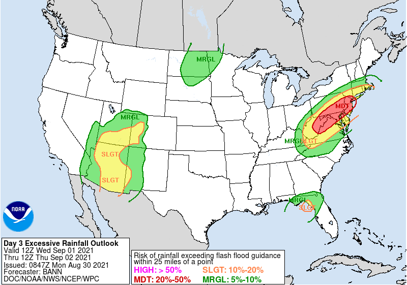
LWX morning AFD seems pretty Gung ho about Ida SHORT TERM /TUESDAY THROUGH THURSDAY/... NOTE: Please refer to the National Hurricane Center (NHC) at hurricanes.gov for latest information on Ida. On Tuesday the frontal boundary will remain stalled over the region. Meanwhile, the remnants of Ida will be moving up the Tennessee Valley later in the day. While the first half of the day will likely be dry, as moisture flow increase ahead of the remnants of Ida, showers and thunderstorms become increasingly likely. More widespread and potentially heavy rain increases markedly after midnight Tuesday night in our western zones. The bulk of the remnants moves through our region on Wednesday however. Heavy rainfall is expected to overspread the region Wednesday afternoon through Wednesday night as Ida interacts with the stalled frontal boundary overhead. The heaviest rainfall is expected over northern and western portions of the forecast area at this time, where the current forecast depicts 3-5 inches of rainfall (isolated amounts of 6"+ will be possible). Further south and east, rainfall amounts are no slouch either, with a general 2-4 inches expected (isolated higher amounts possible). For this reason, much of the area has been placed into a Moderate Risk for excessive rainfall by the Weather Prediction Center (WPC). Instances of flash flooding will be possible (if not likely) with this much rainfall. Additionally, with this much rainfall occurring, we will likely see flooding issues in the main stem rivers in the coming days afterwards (looks like Thursday at this time). See the hydrology section below for more details. As the remnants of Ida move over the region Wednesday, areas south of the track of the low will also have a severe threat as is often the case in tropical remnants. Banded precipitation is expected and will allow for some amount of destabilization during the day. This, paired with an impressive low-mid level shear profile will result in a risk for some isolated tornadoes. A Marginal Risk for severe weather has been issued by the Storm Prediction Center (SPC) as a result. Lastly, the remnants of Ida may still be packing some gusty sustained winds on Wednesday. The latest NHC forecast has 40 mph wind gusts possible. 850-925mb winds in some guidance is suggestive of 40-50 mph gusts perhaps in the higher terrain. So, will have to monitor the potential for a Wind Advisory needing to be issued should that trend continue. Will just have to see how much steam Ida has when it gets a little closer. For now, not going quite that high on winds gusts (will stick closer to 30 mph until things become a bit more certain).
-
Was 946 on the 5am CDT update...
-
@wdrag mentioned it in the NYC forum... but it does look like some of the models are showing a PRE... whether that affects our region or just north is still up in the air
-
00z NAM hitting on Tuesday afternoon for some good severe
-
Hurricane Ida Tropical Cyclone Update NWS National Hurricane Center Miami FL AL092021 500 AM CDT Sun Aug 29 2021 ...NOAA HURRICANE HUNTERS FIND IDA HAS CONTINUED TO STRENGTHEN... ...EXTREMELY DANGEROUS CATEGORY 4 HURRICANE IDA EXPECTED TO MAKE LANDFALL IN SOUTHEASTERN LOUISIANA LATER TODAY... Reports from a NOAA Hurricane Hunter aircraft indicate that maximum sustained winds have increased to 145 mph (230 km/h). A NOAA C-MAN station at Southwest Pass, Louisiana, recently reported a sustained wind of 60 mph (96 km/h) and a gust to 74 mph (118 km/h). SUMMARY OF 500 AM CDT...1000 UTC...INFORMATION ---------------------------------------------- LOCATION...28.2N 89.3W ABOUT 80 MI...130 KM SSE OF GRAND ISLE LOUISIANA ABOUT 65 MI...100 KM S OF THE MOUTH OF THE MISSISSIPPI RIVER MAXIMUM SUSTAINED WINDS...145 MPH...230 KM/H PRESENT MOVEMENT...NW OR 315 DEGREES AT 15 MPH...24 KM/H MINIMUM CENTRAL PRESSURE...946 MB...27.93 INCHES $$ Forecaster Stewart/Papin
-
Written by Stewart Hurricane Ida Discussion Number 12 NWS National Hurricane Center Miami FL AL092021 400 AM CDT Sun Aug 29 2021 Ida has undergone some dramatic inner-core structural changes since the previous advisory. The eye between 25,000-45,000 ft has become circular with a diameter of about 15 nmi now, and at least two eyewall mesocyclones have been noted rotating cyclonically around the eyewall in both radar and high-resolution 1-minute GOES-16 satellite imagery. The result has been rapid strengthening of at least 30 kt during the past 6 hours, along with a pressure drop of more than 15 mb during that same time, with a 6-mb decrease having occurred in the 1-hr period between about 0500-0600 UTC based on Air Force Reserve reconnaissance aircraft eye dropsonde data. The aircraft also measured a maximum 700-mb flight-level wind speed of 133 kt in the northeastern quadrant, along with a peak SFMR surface wind speed of 116 kt. Furthermore, NWS Doppler radar velocity data from Slidell, Louisiana, has recently been measuring velocities of 120-130 kt between 25,000-30,000 ft, which is quite rare, and indicates that Ida is a vertically deep and intense hurricane. Ida was initialized with 115 kt at 0600 UTC, but the 0900 UTC advisory intensity has been increased to 120 kt based on the 133-kt flight-level wind and the improved structure in both radar data and satellite imagery since the 0609 UTC time of that aircraft observation. The initial motion remains northwestward, or 315/13 kt. There is no significant change to the previous forecast track or synoptic reasoning. The subtropical ridge oriented east-west along 30N-31N across the southeastern U.S. is forecast to remain intact through the forecast period with only minor shifts in the location and strength of the ridge. As a result, Ida should continue to move northwestward toward the southeastern Louisiana coast today, followed by a gradual turn toward the north tonight after landfall. On Monday, the hurricane is expected to move northeastward across the Tennessee Valley when Ida moves north of the ridge axis. Impacts and hazards will arrive well before the eye of the hurricane makes landfall. Tropical-storm-force winds are likely to begin later this morning. Therefore, all preparations to protect life and property must be rushed to completion. The new track forecast is basically just an update of the previous advisory track. Ida will remain over waters with high oceanic heat content for another 6 hours or so. Thereafter, the heat content will drop sharply to less than half of the current value of more than 100 units. However, some additional strengthening is expected until landfall occurs. After Ida moves inland tonight, rapid weakening is forecast due to a combination of land interaction, entrainment of drier air, and some increase in westerly vertical wind shear. Users are again reminded to not focus on the exact details of the track forecast as storm surge, wind, and rainfall impacts will extend far from the center. Rainfall impacts will also spread inland across the Lower Mississippi and Tennessee Valleys through early next week. Key Messages: 1. There is a danger of life-threatening storm surge inundation Sunday along the coasts of Louisiana, Mississippi, and Alabama within the Storm Surge Warning area. Extremely life-threatening inundation of 9 feet or greater above ground level is possible somewhere within the area from Morgan City, Louisiana, to the coast of Mississippi. Overtopping of local levees outside of the Hurricane and Storm Damage Risk Reduction System is possible where local inundation values may be higher. Interests throughout the warning area should follow any advice given by local officials. 2. Ida is expected to be an extremely dangerous major hurricane when it reaches the coast of southeastern Louisiana. Hurricane-force winds are expected Sunday in portions of the Hurricane Warning area along the Louisiana coast, including metropolitan New Orleans, with potentially catastrophic wind damage possible where the core of Ida moves onshore. Actions to protect life and property should be rushed to completion in the warning area. 3. Damaging winds, especially in gusts, will spread inland near the track of the center of Ida across portions of southeastern Louisiana and southwestern Mississippi Sunday night and early Monday. These winds will likely lead to widespread tree damage and power outages. 4. Ida will produce heavy rainfall today through Monday across the central Gulf Coast from southeastern Louisiana, coastal Mississippi, to far southwestern Alabama resulting in considerable to life-threatening flash and urban flooding and significant riverine flooding impacts. As Ida moves inland, significant flooding impacts are possible across portions of the Lower Mississippi, Tennessee, and Ohio Valleys through Wednesday. FORECAST POSITIONS AND MAX WINDS INIT 29/0900Z 28.0N 89.1W 120 KT 140 MPH 12H 29/1800Z 29.1N 90.3W 125 KT 145 MPH...NEAR SERN LOUISIANA 24H 30/0600Z 30.6N 91.1W 70 KT 80 MPH...INLAND 36H 30/1800Z 32.2N 91.0W 45 KT 50 MPH...INLAND 48H 31/0600Z 33.8N 90.0W 30 KT 35 MPH...INLAND 60H 31/1800Z 35.4N 87.9W 25 KT 30 MPH...INLAND 72H 01/0600Z 36.7N 85.2W 20 KT 25 MPH...INLAND 96H 02/0600Z 38.9N 78.9W 20 KT 25 MPH...POST-TROP/INLAND 120H 03/0600Z...DISSIPATED $$ Forecaster Stewart
-
-
5am NHC track has Ida near MRB area at 1am THU

