

yoda
-
Posts
60,268 -
Joined
Content Type
Profiles
Blogs
Forums
American Weather
Media Demo
Store
Gallery
Everything posted by yoda
-
I consider low to mid 90s a hot air mass with DPs near 70
-
Will be interesting to see what the Day 3 SPC OTLK looks like
-
00z NAM showing ML Lapse Rates around 7.0 C/KM for Wednesday afternoon into the evening
-
Evening AFD update confirms what @WxUSAF posted above... guess maybe?
-
I would love for it to make it and see a quick storm... but I guess well see... SPC did leave us in SLGT in the 0100 OTLK and disco did mention region has 1500 to 2000 MLCAPE available
-
https://www.spc.noaa.gov/exper/archive/event.php?date=20000809 All the watches, MCDs, and text products issued during the day... plus storm reports as well
-
Should be in the SPC archives ETA: @George BM beat me to it
-
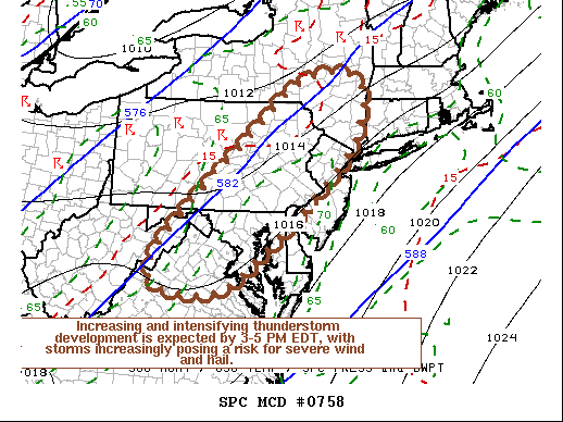
https://www.spc.noaa.gov/products/md/md0758.html Mesoscale Discussion 0758 NWS Storm Prediction Center Norman OK 1127 AM CDT Fri May 29 2020 Areas affected...Northern Mid Atlantic Coast region Concerning...Severe potential...Severe Thunderstorm Watch likely Valid 291627Z - 291730Z Probability of Watch Issuance...80 percent SUMMARY...Thunderstorms may develop across the Poconos and Catskills vicinity as early as the next hour or or so, with a more general increase and intensification of thunderstorm during the 3-5 PM EDT time frame. With strongest storms expected to pose at least a risk for severe wind and hail, one or more severe weather watches seems probable. DISCUSSION...Insolation within a seasonably moist boundary layer (surface dew points around/above 70F) is contributing to moderately large CAPE on the order of 1000-2000+ J/kg, within deepening surface troughing to the lee of the Appalachians. Mid-level flow remains broadly anticyclonic, however deepening convective development is underway aided by orography, particularly across the Poconos into Catskills vicinity. As a short wave trough accelerates northeast of the middle Ohio Valley/central Appalachians region, mid-level flow appears likely to trend increasingly cyclonic across northern Virginia through eastern New York state. This should contribute to an environment increasingly conducive to thunderstorm initiation and intensification. A coinciding strengthening of southwesterly mid-level flow (30-50 kt around 500 mb), will provide sufficient shear for organizing lines and clusters of storms, with isolated discrete supercells also possible. At least some of this activity will pose a risk for large hail, potentially damaging wind gusts, and perhaps a tornado or two. ..Kerr/Grams.. 05/29/2020 ...Please see www.spc.noaa.gov for graphic product... ATTN...WFO...OKX...ALY...PHI...BGM...AKQ...CTP...LWX..
-
Severe tstorm watch coming soon for C VA into C PA
-
From the SPC 4-8 day OTLK disco:
-
2/15/15 on the new Day 1 OTLK
-
Hopefully all went well and you are doing better
-
This looks fun
-
00z HRRR has some morning activity between 09z and 11z coming up from the south into DC metro... nothing severe... but might make for quite a soupy airmass in the morning as the sun appears... waiting for the rest of the run to see what happens in the afternoon around here ETA: Nothing really through 23z so far... kinda surprised tbh
-
BULLETIN - EAS ACTIVATION REQUESTED Tornado Warning National Weather Service Lincoln IL 720 PM CDT Thu May 28 2020 The National Weather Service in Lincoln has issued a * Tornado Warning for... Central Moultrie County in central Illinois... * Until 745 PM CDT. * At 717 PM CDT, a confirmed landspout tornado was located south of Dalton City, or about 3 miles northwest of Bethany, moving east at 30 mph. HAZARD...Very weak or landspout tornadoes. SOURCE...Weather spotters confirmed landspout tornado. IMPACT...Expect damage to mobile homes, roofs, and vehicles. * The tornado will be near... Bethany around 720 PM CDT. Sullivan and Lovington around 735 PM CDT.
-
This afternoons LWX severe threat disco for tomorrow... mentions cap for i95 corridor till evening... also mentions supercells possible
-
For Friday, day 2 morning SPC OTLK
-
Scherzer leading the way toward no baseball season https://www.espn.com/mlb/story/_/id/29232753/sources-mlbpa-counter-mlb-proposal-more-games-full-prorated-salaries
-
MRGL risk for Day 1... 2% TOR and 5% wind... for i95 corridor and west TOR risk is from N VA into C PA on day 1 OTLK No real disco for our area though besides few short sentences lol SLGT for day 2 for most of LWX CWA... 2% TOR and 15% wind... potential for greater tornado risk stated in disco on day 2 btw... all depends on low level flow and surface wind direction
-
Well that was a big waste of gas then lol
-
Good article on how it would all work https://www.espn.com/nhl/story/_/id/29225074/nhl-adopts-24-team-playoff-season-returns
-
I dunno reading this https://www.espn.com/mlb/story/_/id/29224973/sources-mlb-proposal-includes-pay-cuts-highest-paid-players
-
NHL regular season over... will resume with 24 team playoff... but not before July 1st per announcement from Bettman @Scraff @nj2va @nw baltimore wx
-
LWX in their afternoon AFD did mention this... but stated not many members showed a heavy rain threat for Wed-Thur... also maybe a severe threat on Friday


