

yoda
-
Posts
60,268 -
Joined
Content Type
Profiles
Blogs
Forums
American Weather
Media Demo
Store
Gallery
Everything posted by yoda
-
00z EURO shows nothing in the tropical department either tonight except for a small SLP north of the islands (Leeward) at 240
-
00z GFS tonight shows no hurricanes at all during its entire run... there is a tropical disturbance late in the run but it mills around the Yucatan peninsula and never really develops into much of anything due to land interaction... though it tries to develop as the run ends
-
Seeing flashes of lightning out my window every few seconds but with no thunder... so must be just missing the storm off to my NW where you are ETA: Speaking of: Short Term Forecast National Weather Service Baltimore MD/Washington DC 314 AM EDT Thu Aug 6 2020 MDZ004-503>505-VAZ053-506-060745- Central and Southeast Montgomery-Northwest Montgomery-Frederick-Northwest Howard-Fairfax-Eastern Loudoun- 314 AM EDT Thu Aug 6 2020 ...A STRONG THUNDERSTORM WILL AFFECT NORTHWESTERN HOWARD AND MONTGOMERY COUNTIES IN CENTRAL MARYLAND...SOUTHEASTERN FREDERICK COUNTY IN NORTH CENTRAL MARYLAND...SOUTHEASTERN LOUDOUN AND NORTHWESTERN FAIRFAX COUNTIES IN NORTHERN VIRGINIA... At 313 AM EDT, a strong thunderstorm was located over Herndon, moving northeast at 25 mph. Locations impacted include... Germantown, Rockville, Bethesda, Gaithersburg, Reston, Leesburg, Olney, Herndon, Vienna, Damascus, Broadlands, Lansdowne, Lowes Island, Brambleton, Pimmit Hills, Poolesville, American Legion Bridge, Aspen Hill, Potomac and North Bethesda. Torrential rainfall is occurring with this storm, and may reduce visibilities. Frequent cloud to ground lightning is occurring with this storm. Lightning can strike 10 miles away from a thunderstorm. Seek a safe shelter inside a building or vehicle.
-
Flood Watch National Weather Service Baltimore MD/Washington DC 246 AM EDT Thu Aug 6 2020 VAZ026-029-038>040-051-507-062145- /O.EXT.KLWX.FF.A.0018.000000T0000Z-200807T0400Z/ /00000.0.ER.000000T0000Z.000000T0000Z.000000T0000Z.OO/ Rockingham-Page-Greene-Madison-Rappahannock-Culpeper- Northern Virginia Blue Ridge- Including the cities of Harrisonburg, Luray, Shenandoah, Stanley, Stanardsville, Madison, Washington, Culpeper, and Big Meadows 246 AM EDT Thu Aug 6 2020 ...FLASH FLOOD WATCH NOW IN EFFECT THROUGH THIS EVENING... The Flash Flood Watch is now in effect for * Portions of central Virginia, northern Virginia, northwest Virginia, and western Virginia, including the following areas, in central Virginia, Greene. In northern Virginia, Culpeper. In northwest Virginia, Madison, Northern Virginia Blue Ridge, Page, and Rappahannock. In western Virginia, Rockingham. * Through this evening * Numerous slow moving showers and thunderstorms continue to develop across the region and should expand and redevelop with time. Locations which are repetitively affected could receive multiple-inch rainfall totals. This could lead to rapid rises on streams and flash flooding of low lying areas.
-
here come the FFWs Flood Watch National Weather Service Baltimore MD/Washington DC 246 AM EDT Thu Aug 6 2020 DCZ001-MDZ004>006-011-013-014-016>018-503>508-VAZ025-036-037-050- 052>057-501-502-505-506-508-062145- /O.EXB.KLWX.FF.A.0018.000000T0000Z-200807T0400Z/ /00000.0.ER.000000T0000Z.000000T0000Z.000000T0000Z.OO/ District of Columbia-Frederick MD-Carroll-Northern Baltimore- Southern Baltimore-Prince Georges-Anne Arundel-Charles-St. Marys- Calvert-Northwest Montgomery-Central and Southeast Montgomery- Northwest Howard-Central and Southeast Howard-Northwest Harford- Southeast Harford-Augusta-Nelson-Albemarle-Orange- Prince William/Manassas/Manassas Park-Fairfax- Arlington/Falls Church/Alexandria-Stafford-Spotsylvania- King George-Northern Fauquier-Southern Fauquier-Western Loudoun- Eastern Loudoun-Central Virginia Blue Ridge- Including the cities of Washington, Frederick, Ballenger Creek, Eldersburg, Westminster, Reisterstown, Cockeysville, Baltimore, Bowie, Suitland-Silver Hill, Clinton, College Park, Greenbelt, Laurel, Camp Springs, Glen Burnie, Annapolis, Severn, South Gate, Severna Park, Arnold, Odenton, St. Charles, Waldorf, Lexington Park, California, Chesapeake Beach, Huntingtown, Dunkirk, North Beach, Lusby, Prince Frederick, Germantown, Damascus, Bethesda, Rockville, Gaithersburg, Silver Spring, Lisbon, Columbia, Ellicott City, Jarrettsville, Aberdeen, Staunton, Waynesboro, Stuarts Draft, Lovingston, Charlottesville, Orange, Gordonsville, Dale City, Manassas, Woodbridge, Lake Ridge, Montclair, Reston, Herndon, Annandale, Centreville, Chantilly, McLean, Franconia, Arlington, Alexandria, Falls Church, Falmouth, Fredericksburg, Dahlgren, Warrenton, Turnbull, Purcellville, Leesburg, Ashburn, Sterling, and Wintergreen 246 AM EDT Thu Aug 6 2020 ...FLASH FLOOD WATCH IN EFFECT THROUGH THIS EVENING... The National Weather Service in Sterling Virginia has expanded the * Flash Flood Watch to include portions of Maryland, The District of Columbia, and Virginia, including the following areas, in Maryland, Anne Arundel, Calvert, Carroll, Central and Southeast Howard, Central and Southeast Montgomery, Charles, Frederick, Northern Baltimore, Northwest Harford, Northwest Howard, Northwest Montgomery, Prince Georges, Southeast Harford, Southern Baltimore, and St. Marys. The District of Columbia. In Virginia, Albemarle, Arlington/Falls Church/Alexandria, Augusta, Central Virginia Blue Ridge, Eastern Loudoun, Fairfax, King George, Nelson, Northern Fauquier, Orange, Prince William, Southern Fauquier, Spotsylvania, Stafford, and Western Loudoun. * Through this evening * Numerous slow moving showers and thunderstorms continue to develop across the region and should expand and redevelop with time. Locations which are repetitively affected could receive multiple-inch rainfall totals. This could lead to rapid rises on streams and flash flooding of low lying areas.
-
Looks like it... BTW, does radarscope overdo the rotation markers? Like there is one for the tiny storm by Boyce, VA right now
-
Day 2 MRGL risk (Thursday) for a few damaging wind gusts possible
-
So @Damage In Tolland did lose power then? For days and days? My bad for betting he wouldn't
-
I bet you keep your power
-
Read the disco I bolded lol... good luck up there with your damage
-
You're gonna have to travel to see a tornado
-
Day 1 Convective Outlook NWS Storm Prediction Center Norman OK 0704 AM CDT Tue Aug 04 2020 Valid 041300Z - 051200Z ...THERE IS AN ENHANCED RISK OF SEVERE THUNDERSTORMS PORTIONS OF THE NORTHEAST... ...THERE IS A SLIGHT RISK OF SEVERE THUNDERSTORMS CENTRAL HIGH PLAINS... ...SUMMARY... Tornadoes will be most likely through this afternoon from Delaware into southern New England, with a lingering threat for a couple tornadoes across northern New England this evening. Scattered large hail and severe wind gusts will be possible across the central High Plains from mid-afternoon to mid-evening. ...DE to New England... As T.C. Isaias rapidly shifts northeastward today, an accompanying very moist low-level environment will permit maintenance of weak buoyancy across the coastal plain of the Northeast into southern New England. Clusters and cells of shallow convection to the north and east of the circulation center will continue to pose a risk for tornadoes. The greatest risk will be where mid 70s surface dew points can become coincident with immense low-level hodograph curvature from DE to the NYC tri-state area. Most guidance is consistent in suggesting the very rich surface moisture will become pinched off across parts of southern New England later today. This suggests the overall tornado risk should decrease this evening as it spreads into northern New England
-
Wiz wont be pleased with the 1300 SPC OTLK disco lol
-
Tornado warning for PHL proper
-
https://www.spc.noaa.gov/products/md/md1393.html
-
 https://www.spc.noaa.gov/products/md/md1393.html
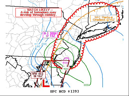
- 1,530 replies
-
- 2
-

-
- heavy rain
- rip current
- (and 1 more)
-
BULLETIN - EAS ACTIVATION REQUESTED Tornado Warning National Weather Service Mount Holly NJ 450 AM EDT Tue Aug 4 2020 The National Weather Service in Mount Holly NJ has issued a * Tornado Warning for... East central Sussex County in southern Delaware... * Until 515 AM EDT. * At 449 AM EDT, a severe thunderstorm capable of producing a tornado was located near Millville, or 15 miles east of Georgetown, moving north at 30 mph. HAZARD...Tornado. SOURCE...Radar indicated rotation. IMPACT...Flying debris will be dangerous to those caught without shelter. Mobile homes will be damaged or destroyed. Damage to roofs, windows, and vehicles will occur. Tree damage is likely. * Locations impacted include... Henlopen Acres and Long Neck.
-
And 94L is gone pretty much Tropical Weather Outlook NWS National Hurricane Center Miami FL 200 AM EDT Tue Aug 4 2020 For the North Atlantic...Caribbean Sea and the Gulf of Mexico: The National Hurricane Center is issuing advisories on Hurricane Isaias, located inland over southeastern North Carolina. 1. Showers and thunderstorms have mostly dissipated near a trough of low pressure located several hundred miles south-southwest of Bermuda. Although a weak area of low pressure is expected to form over the next day or so, abundant dry air surrounding the system is likely to limit significant development. This system is forecast to move northwestward at about 10 mph over the southwestern Atlantic today, stall several hundred miles southwest of Bermuda tonight, and then drift southwestward on Thursday. * Formation chance through 48 hours...low...30 percent. * Formation chance through 5 days...low...30 percent. Forecaster Berg
-
Surprised @weatherwiz isn't taking the 05z HRRR into the back room for some... fun...
-
Pero tengo malas noticias para ustedes, tipos.
-
The trolls have arrived and ready to storm cancel before it starts lol
-
Carlson not playing makes me wonder though... is he just taking the game off for "rest" since the games don't really count for much... or is the supposed injury more serious?
-
NHC disagreed on the 2AM TWO Tropical Weather Outlook NWS National Hurricane Center Miami FL 200 AM EDT Mon Aug 3 2020 For the North Atlantic...Caribbean Sea and the Gulf of Mexico: The National Hurricane Center is issuing advisories on Tropical Storm Isaias, located just offshore of east-central Florida. Recent satellite-derived wind data indicate that the area of disturbed weather located a few hundred miles north of the northern Leeward Islands does not have a surface circulation, and the associated shower activity is not well organized. However, environmental conditions could allow for some slow development of this system during the next several days, with a tropical depression possibly forming later this week. This system is forecast to move northwestward at about 15 mph over the southwestern Atlantic today and on Tuesday and then stall several hundred miles southwest of Bermuda by the middle to latter part of the week. * Formation chance through 48 hours...medium...40 percent. * Formation chance through 5 days...medium...60 percent. $$ Forecaster Berg
-
Let's see if Holtby can bring home the bacon again in the playoffs for you all... otherwise Copley in net
-
Sunday, August 2, 2020 Convective/Severe Potential
yoda replied to weatherwiz's topic in New England
so... @weatherwiz is headed to N NY?


