

yoda
-
Posts
60,268 -
Joined
Content Type
Profiles
Blogs
Forums
American Weather
Media Demo
Store
Gallery
Everything posted by yoda
-
BULLETIN - EAS ACTIVATION REQUESTED Tornado Warning National Weather Service Baltimore MD/Washington DC 443 PM EDT Thu Sep 3 2020 The National Weather Service in Sterling Virginia has issued a * Tornado Warning for... South central Howard County in central Maryland... Southeastern Montgomery County in central Maryland... North central Prince Georges County in central Maryland... * Until 515 PM EDT. * At 443 PM EDT, a severe thunderstorm capable of producing a tornado was located over North Potomac, or over Gaithersburg, moving east at 40 mph. HAZARD...Tornado. SOURCE...Radar indicated rotation. IMPACT...For those in the direct path of a tornado touchdown, flying debris will be dangerous to those caught without shelter. Damage to roofs, siding, and windows may occur. Mobile homes may be damaged or destroyed. Tree damage is likely. * This dangerous storm will be near... Redland around 450 PM EDT. Olney, North Bethesda, North Kensington, South Kensington and Rossmoor around 455 PM EDT. Aspen Hill, White Oak, Kemp Mill, Forest Glen and Wheaton-Glenmont around 500 PM EDT. Fairland, Adelphi, Colesville and Hillandale around 505 PM EDT. College Park, Greenbelt and Beltsville around 510 PM EDT. Laurel and Savage-guilford around 515 PM EDT. Other locations impacted by this tornadic thunderstorm include Fulton, Garrett Park, Derwood, Spencerville, Cloverly, Calverton, Washington Grove, Ednor, Ashton and Scaggsville. PRECAUTIONARY/PREPAREDNESS ACTIONS... TAKE COVER NOW! Move to a basement or an interior room on the lowest floor of a sturdy building. Avoid windows. If you are outdoors, in a mobile home, or in a vehicle, move to the closest substantial shelter and protect yourself from flying debris.
-
BULLETIN - EAS ACTIVATION REQUESTED Tornado Warning National Weather Service Baltimore MD/Washington DC 436 PM EDT Thu Sep 3 2020 The National Weather Service in Sterling Virginia has issued a * Tornado Warning for... Southeastern Carroll County in north central Maryland... Northwestern Baltimore City in northern Maryland... Northeastern Howard County in central Maryland... Southwestern Baltimore County in northern Maryland... * Until 500 PM EDT. * At 436 PM EDT, a severe thunderstorm capable of producing a tornado was located near Randallstown, or near Historic Ellicott City, moving east at 30 mph. HAZARD...Tornado. SOURCE...Radar indicated rotation. IMPACT...For those in the direct path of a tornado touchdown, flying debris will be dangerous to those caught without shelter. Damage to roofs, siding, and windows may occur. Mobile homes may be damaged or destroyed. Tree damage is likely. * This dangerous storm will be near... Ellicott City and Randallstown around 440 PM EDT. Catonsville, Owings Mills and Milford Mill around 450 PM EDT. Lochearn around 455 PM EDT. Pikesville, Towson and Woodlawn around 500 PM EDT. Other locations impacted by this tornadic thunderstorm include Garrison, Mcdonogh, Ruxton, Daniels, Marriottsville, Woodstock, Granite and Riderwood.
-
BULLETIN - IMMEDIATE BROADCAST REQUESTED Severe Thunderstorm Warning National Weather Service Baltimore MD/Washington DC 436 PM EDT Thu Sep 3 2020 The National Weather Service in Sterling Virginia has issued a * Severe Thunderstorm Warning for... The northern District of Columbia... South central Howard County in central Maryland... Montgomery County in central Maryland... Northwestern Prince Georges County in central Maryland... Southeastern Loudoun County in northern Virginia... Northeastern Fairfax County in northern Virginia... * Until 530 PM EDT. * At 436 PM EDT, a severe thunderstorm was located near Lowes Island, moving east at 25 mph. HAZARD...65 mph wind gusts. SOURCE...Radar indicated. IMPACT...Damaging winds will cause some trees and large branches to fall. This could injure those outdoors, as well as damage homes and vehicles. Roadways may become blocked by downed trees. Localized power outages are possible. Unsecured light objects may become projectiles. * Locations impacted include... Columbia, Germantown, Rockville, Bethesda, Gaithersburg, Reston, Olney, College Park, Greenbelt, Langley Park, Beltsville, Lowes Island, Bladensburg, Poolesville, American Legion Bridge, Fort Totten, University of Maryland, Howard University, Aspen Hill and Potomac. PRECAUTIONARY/PREPAREDNESS ACTIONS... A Tornado Watch remains in effect until 1000 PM EDT for District of Columbia...central Maryland...and northern Virginia. Remain alert for a possible tornado! Tornadoes can develop quickly from severe thunderstorms. If you spot a tornado go at once into the basement or small central room in a sturdy structure. && LAT...LON 3900 7743 3920 7738 3925 7691 3889 7690 TIME...MOT...LOC 2036Z 267DEG 24KT 3911 7733 TORNADO...POSSIBLE HAIL...<.75IN WIND...60MPH
-
Tornado warning Carroll/Howard/Frederick in MD till 415pm
-
60/20 tor probs 70/30 wind probs
-
Hail to 1 inch and isolated significant gusts to 75mph
-
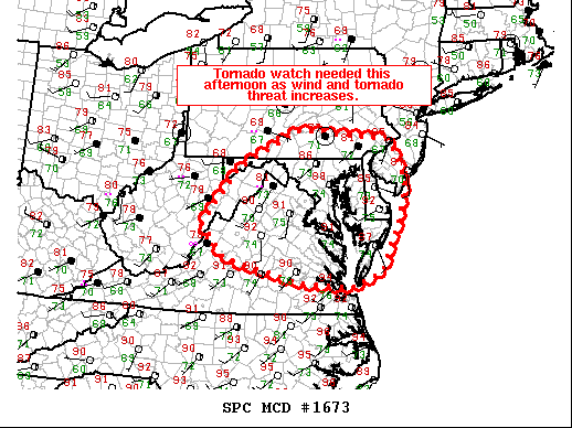
Mesoscale Discussion 1673 NWS Storm Prediction Center Norman OK 0206 PM CDT Thu Sep 03 2020 Areas affected...the Mid-Atlantic Concerning...Severe potential...Tornado Watch likely Valid 031906Z - 032100Z Probability of Watch Issuance...95 percent SUMMARY...A tornado watch will be needed this afternoon as a damaging wind and tornado threat increases. DISCUSSION...A broad area of shower activity extends from the Ohio Valley into Pennsylvania and New York amid a belt of strong mid-level flow. Areas south and east of this activity have slowly destabilized through the day with temperatures now in the upper 80s to low 90s in northern Virginia, eastern Maryland, and Delaware. In addition, the boundary layer is very moist with dewpoints in the mid to upper 70s. This has yielded moderate MLCAPE ranging from 1000 to 2000 J/kg across the region despite very weak mid-level lapse rates (5 C/km per 18Z IAD RAOB). Expect at least a few strong storms to develop in the eastern periphery of the cloud shield in the next 1-2 hours as destabilization continues and deep-layer ascent increases ahead of a shortwave moving out of West Virginia. Once storms develop, they will likely become supercellular, at least initially, given 40-45 kts of effective shear (per KLWX VWP and 18Z IAD RAOB). 18Z IAD RAOB showed relatively weak flow in the lowest 1.5 km, but upstream VWP from KRLX shows strong (40 kt) flow at 1km. Once this overspreads northern Virginia, Maryland, and Pennsylvania in a few hours, the damaging wind threat will increase and low-level shear will increase which should increase the tornado threat. The best tornado threat will likely be across northern Virginia, southern Maryland, and far southern Pennsylvania where there has been less mixing and surface winds remain southerly or south-southeasterly. A tornado watch will likely be needed in the next hour or two as storm coverage/intensity increases. ..Bentley/Grams.. 09/03/2020 ...Please see www.spc.noaa.gov for graphic product... ATTN...WFO...PHI...AKQ...CTP...LWX...RNK...PBZ...RLX...
-
MCD issued... tornado watch likely... 95 percent
-
Kind of surprised no MCD yet from SPC
-
Ugh it's hot and humid out... we better get some storms this afternoon
-
On your marks... Tropical Weather Outlook NWS National Hurricane Center Miami FL 200 AM EDT Thu Sep 3 2020 For the North Atlantic...Caribbean Sea and the Gulf of Mexico: The National Hurricane Center is issuing advisories on recently upgraded Hurricane Nana, approaching the coast of Belize, and on Tropical Depression Omar, located a few hundred miles north of Bermuda. 1. A broad area of low pressure located over the eastern tropical Atlantic several hundred miles west-southwest of the Cabo Verde Islands continues to produce a small area of showers and thunderstorms. This system is expected to interact with a tropical wave approaching from the east over the weekend, and it is unclear if the interaction will enhance or inhibit development of this system while it meanders over the eastern and central tropical Atlantic through early next week. * Formation chance through 48 hours...low...20 percent. * Formation chance through 5 days...low...30 percent. 2. A tropical wave located off the coast of west Africa is merging with another disturbance located a couple of hundred miles south of the Cabo Verde Islands, resulting in an extensive area of disorganized showers and thunderstorms. Development of this system is likely to be slow during the next couple of days while it moves west- northwestward at about 15 mph, and a tropical depression is more likely to form early next week over the central tropical Atlantic where environmental conditions are forecast to be more favorable for development. * Formation chance through 48 hours...low...20 percent. * Formation chance through 5 days...high...70 percent. 3. Another tropical wave is forecast to move off the west coast of Africa over the weekend. An area of low pressure is expected to form from the wave, and some development of this low will be possible early next week while it moves generally westward over the far eastern tropical Atlantic. * Formation chance through 48 hours...low...near 0 percent. * Formation chance through 5 days...low...20 percent. Forecaster Berg
-
I wouldn't say busted looking at the reports https://www.spc.noaa.gov/exper/archive/event.php?date=20120601
-
New day 1 is out.... 0600 OTLK is ENH risk with 10 TOR/5 HAIL/30 WIND
-
June 4th and June 10th and June 16th 2008 were MOD risks... but for wind down here
-
I believe this is the last event that had hatched tor probs in the LWX CWA https://www.spc.noaa.gov/exper/archive/event.php?date=20160224
-
Evening AFD LWX disco update for tomorrow
-
Those were at KIAD... KDCA and KEZF look a bit more nasty... along with KBWI too ETA: especially that sounding at KBWI at 00z Friday
-
Again with the no sprinkler
-
Those are some nasty soundings on the 00z NAM from 18z THURS to 03z FRI
-
Are we going to use this thread for both days? Or should we risk getting denied by posting a separate thread lol
-
Tornado watch coming shortly
-
Tropical Storm Nana Discussion Number 5 NWS National Hurricane Center Miami FL AL162020 500 AM EDT Wed Sep 02 2020 Nana's Central Dense Overcast has become a little better defined, with cloud tops to -80 deg C or colder. Upper-level outflow continues to be somewhat inhibited over the northern portion of the circulation. SFMR-observed surface winds and adjusted flight-level winds from an Air Force Hurricane Hunter aircraft indicated an intensity of 50 kt. Although northerly shear is likely to limit intensification, the environment is conducive enough for Nana to strengthen into a hurricane later today. The official intensity forecast is close to the Decay-SHIPS prediction based on the ECMWF global model forecast fields. Center fixes from the aircraft indicate that the motion continues to be generally westward, or 270/16 kt, to the south of a strong mid-level high pressure area. Over the next couple of days, the ridge is expected to be maintained or to build a little more to the west. This should keep Nana on a westward or slightly south-of-west track until it moves into Central America. The official track forecast is close to the previous one and also very close to the latest Florida State University Superensemble prediction. Observations from the aircraft and NOAA data buoy 42057 indicate that Nana is a rather small tropical cyclone, with tropical-storm-force winds extending 60 n mi or less from the center. KEY MESSAGES: 1. Tropical Storm Nana is forecast to be a hurricane as it approaches the coast, and interests in Honduras, Guatemala, Belize, and the Yucatan Peninsula should closely monitor the progress of this storm. Strong winds, dangerous storm surge and very heavy rainfall causing flash flooding are becoming more likely from Nana. FORECAST POSITIONS AND MAX WINDS INIT 02/0900Z 17.0N 82.7W 50 KT 60 MPH 12H 02/1800Z 16.9N 85.0W 60 KT 70 MPH 24H 03/0600Z 16.8N 87.6W 65 KT 75 MPH 36H 03/1800Z 16.5N 89.8W 50 KT 60 MPH...INLAND 48H 04/0600Z 16.4N 92.1W 30 KT 35 MPH...INLAND 60H 04/1800Z 16.1N 93.9W 20 KT 25 MPH...POST-TROP/REMNT LOW 72H 05/0600Z...DISSIPATED $$ Forecaster Pasch
-
BULLETIN Tropical Storm Nana Advisory Number 5 NWS National Hurricane Center Miami FL AL162020 500 AM EDT Wed Sep 02 2020 ...NANA CONTINUES WESTWARD... ...LIKELY TO BECOME A HURRICANE BY TONIGHT... SUMMARY OF 500 AM EDT...0900 UTC...INFORMATION ---------------------------------------------- LOCATION...17.0N 82.7W ABOUT 210 MI...335 KM ENE OF LIMON HONDURAS ABOUT 365 MI...585 KM E OF BELIZE CITY MAXIMUM SUSTAINED WINDS...60 MPH...95 KM/H PRESENT MOVEMENT...W OR 270 DEGREES AT 18 MPH...30 KM/H MINIMUM CENTRAL PRESSURE...997 MB...29.44 INCHES
-
LWX goes big for today and tomorrow in their morning AFD
-
BULLETIN Tropical Storm Nana Intermediate Advisory Number 4A NWS National Hurricane Center Miami FL AL162020 200 AM EDT Wed Sep 02 2020 ...NANA EXPECTED TO BECOME A HURRICANE BY TONIGHT... SUMMARY OF 200 AM EDT...0600 UTC...INFORMATION ---------------------------------------------- LOCATION...17.0N 81.8W ABOUT 265 MI...425 KM ENE OF LIMON HONDURAS ABOUT 425 MI...680 KM E OF BELIZE CITY MAXIMUM SUSTAINED WINDS...60 MPH...95 KM/H PRESENT MOVEMENT...W OR 270 DEGREES AT 18 MPH...30 KM/H MINIMUM CENTRAL PRESSURE...1000 MB...29.53 INCHES


