yoda
-
Posts
60,268 -
Joined
Content Type
Profiles
Blogs
Forums
American Weather
Media Demo
Store
Gallery
Everything posted by yoda
-
Seeing pics on Twitter of SC getting hit hard with snow https://mobile.twitter.com/ReedTimmerAccu/status/1358264562424958977 https://mobile.twitter.com/zachprelutsky/status/1358230687975931906
-

Feb Long Range Discussion (Day 3 and beyond) - MERGED
yoda replied to WinterWxLuvr's topic in Mid Atlantic
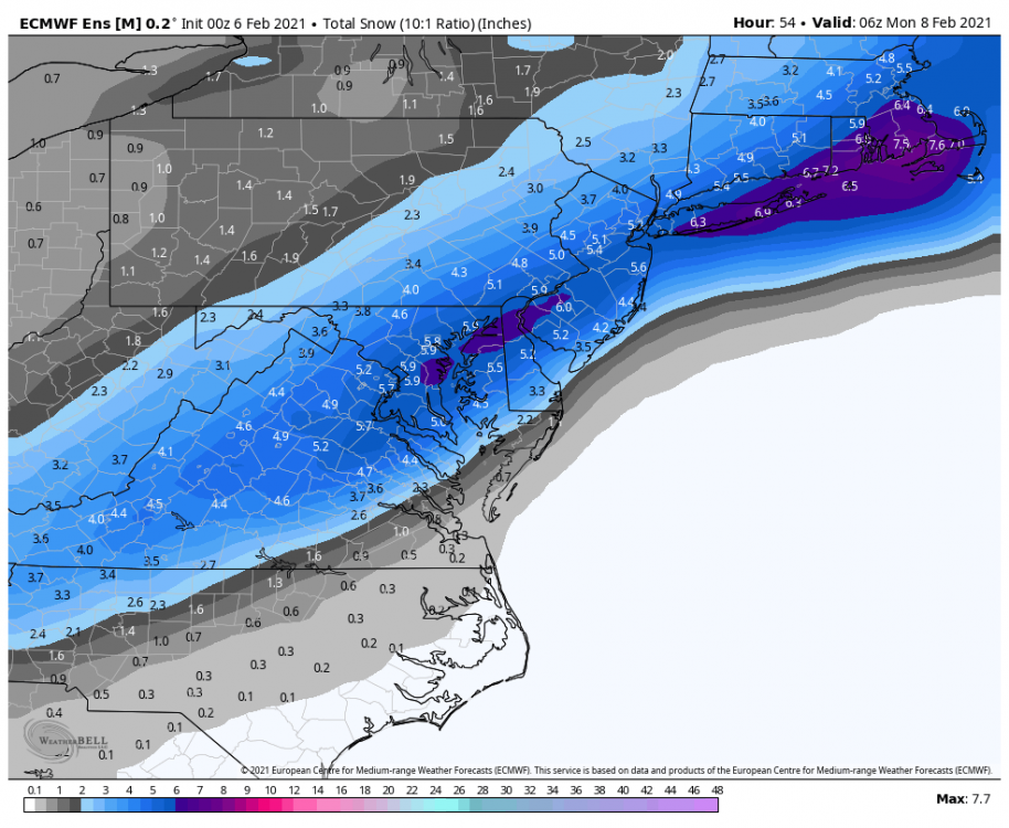
Both the 00z GFS and 00z CMC have intrigue for the 15th to 17th time period... 00z CMC just looks a little weird IMO Day 9 into Day 10 with its precip field/orientation -
FWIW, 06z HRDPS has a big NW shift from its 00z run
-
Feb Long Range Discussion (Day 3 and beyond) - MERGED
yoda replied to WinterWxLuvr's topic in Mid Atlantic
better have syrup on them -
Feb Long Range Discussion (Day 3 and beyond) - MERGED
yoda replied to WinterWxLuvr's topic in Mid Atlantic
Wind chills of -20 to -30 for majority of region? 30-40 below zero along i81 corridor? And up to 55 below zero in Garrett County? You want it next Saturday night into Sunday morning? Its yours my friend -
Feb Long Range Discussion (Day 3 and beyond) - MERGED
yoda replied to WinterWxLuvr's topic in Mid Atlantic
06z GFS says hi welcome to the icebox on Feb 13 where highs are below zero in the mountains and 0-10 elsewhere oh hai Saturday night... lows -10 near DC... -20 to -25 along Allegheny Front -
Feb Long Range Discussion (Day 3 and beyond) - MERGED
yoda replied to WinterWxLuvr's topic in Mid Atlantic
06z GFS signaling big ice threat mid to late week... then some heavy snow on top to finish it off And then sends us into the icebox right after -
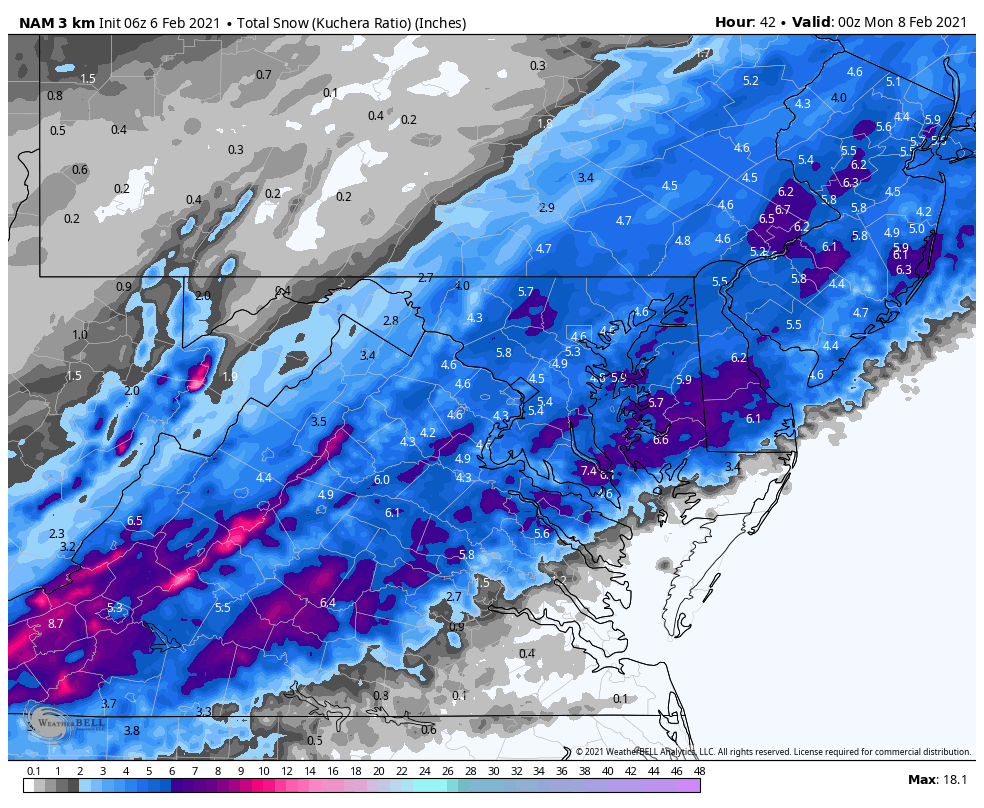
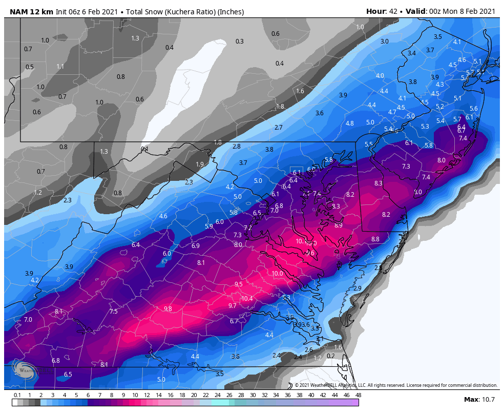
which results in below re snow accum changes on the 06z RGEM compared to the 00z RGEM
-
-
06z RGEM is a big nudge NW in portions of the QPF field compared to 00z
-
FWIW, 06z ICON still looks good for most
-
LWX morning AFD for the event
-
Feb Long Range Discussion (Day 3 and beyond) - MERGED
yoda replied to WinterWxLuvr's topic in Mid Atlantic
LWX morning AFD for Wed-Fri -

-
Still puts down 3 to 6/4 to 8 i95 and just east
-
URGENT - WINTER WEATHER MESSAGE National Weather Service Wakefield VA 335 AM EST Sat Feb 6 2021 VAZ512>516-061645- /O.UPG.KAKQ.WS.A.0002.210207T0000Z-210207T1700Z/ /O.NEW.KAKQ.WW.Y.0006.210207T0300Z-210207T1800Z/ Eastern Hanover-Western Chesterfield- Eastern Chesterfield (Including Col. Heights)- Western Henrico (Including the City of Richmond)-Eastern Henrico- Including the cities of Mechanicsville, Bon Air, Midlothian, Chesterfield, Chester, Colonial Heights, Richmond, and Sandston 335 AM EST Sat Feb 6 2021 ...WINTER WEATHER ADVISORY IN EFFECT FROM 10 PM THIS EVENING TO 1 PM EST SUNDAY... * WHAT...Snow expected. Total snow accumulations of 1 to 3 inches. * WHERE...Eastern Hanover, Western Chesterfield, Eastern Chesterfield (Including Col. Heights), Western Henrico (Including the City of Richmond) and Eastern Henrico Counties. * WHEN...From 10 PM this evening to 1 PM EST Sunday. * IMPACTS...Plan on slippery road conditions.
-
URGENT - WINTER WEATHER MESSAGE National Weather Service Wakefield VA 335 AM EST Sat Feb 6 2021 MDZ021-VAZ075>078-085-522-061645- /O.UPG.KAKQ.WS.A.0002.210207T0500Z-210207T1800Z/ /O.NEW.KAKQ.WW.Y.0006.210207T0500Z-210207T1800Z/ Dorchester-Westmoreland-Richmond-Northumberland-Lancaster- Middlesex-Eastern Essex- Including the cities of Cambridge, Sandy Point, Westmoreland, Colonial Beach, Leedstown, Oak Grove, Potomac Beach, Potomac Mills, Naylors Beach, Downing, Emmerton, Ethel, Farnham, Haynesville, Kennard, Lewisetta, Alfonso, Beanes Corner, Brook Vale, Kilmarnock, Lancaster, Lively, Regina, Grafton, Harmony Village, Church View, Cooper, Healys, Jamaica, Nesting, and Dunnsville 335 AM EST Sat Feb 6 2021 ...WINTER WEATHER ADVISORY IN EFFECT FROM MIDNIGHT TONIGHT TO 1 PM EST SUNDAY... * WHAT...Snow epxected. Total snow accumulations of 2 to 4 inches. * WHERE...Portions of southeast Maryland and east central and eastern Virginia. * WHEN...From midnight tonight to 1 PM EST Sunday. * IMPACTS...Plan on slippery road conditions.
-
URGENT - WINTER WEATHER MESSAGE National Weather Service Wakefield VA 335 AM EST Sat Feb 6 2021 VAZ083-518-520-061645- /O.UPG.KAKQ.WS.A.0002.210207T0500Z-210207T1800Z/ /O.NEW.KAKQ.WW.Y.0006.210207T0300Z-210207T1800Z/ New Kent-Eastern King William-Eastern King and Queen- Including the cities of Bottoms Bridge, Browns Corner, Mountcastle, New Kent Airport, Orapax Farms, Quinton, Talleysville, King William, West Point, and King And Queen Court House 335 AM EST Sat Feb 6 2021 ...WINTER WEATHER ADVISORY IN EFFECT FROM 10 PM THIS EVENING TO 1 PM EST SUNDAY... * WHAT...Snow epxected. Total snow accumulations of 1 to 3 inches. * WHERE...New Kent, Eastern King William and Eastern King and Queen Counties. * WHEN...From 10 PM this evening to 1 PM EST Sunday. * IMPACTS...Plan on slippery road conditions.
-
URGENT - WINTER WEATHER MESSAGE National Weather Service Wakefield VA 335 AM EST Sat Feb 6 2021 VAZ064-517-519-521-061645- /O.UPG.KAKQ.WS.A.0002.210207T0500Z-210207T1800Z/ /O.NEW.KAKQ.WS.W.0002.210207T0300Z-210207T1800Z/ Caroline-Western King William-Western King and Queen- Western Essex- Including the cities of Corbin, Burruss Corner, Cedar Fork, Dawn, Aylett, Beazley, Biscoe, Henley Fork, Indian Neck, Newtown, Owenton, Saint Stephens Church, and Tappahannock 335 AM EST Sat Feb 6 2021 ...WINTER STORM WARNING IN EFFECT FROM 10 PM THIS EVENING TO 1 PM EST SUNDAY... * WHAT...Heavy snow expected. Total snow accumulations of 4 to 6 inches. * WHERE...Caroline, Western King William, Western King and Queen and Western Essex Counties. * WHEN...From 10 PM this evening to 1 PM EST Sunday. * IMPACTS...Plan on slippery road conditions.
-
URGENT - WINTER WEATHER MESSAGE National Weather Service Wakefield VA 335 AM EST Sat Feb 6 2021 VAZ048-061-062-069-509>511-061645- /O.UPG.KAKQ.WS.A.0002.210207T0000Z-210207T1700Z/ /O.NEW.KAKQ.WS.W.0002.210207T0300Z-210207T1800Z/ Fluvanna-Cumberland-Goochland-Powhatan-Western Louisa- Eastern Louisa-Western Hanover- Including the cities of Bybee, Central Plains, Cunningham, Lake Monticello, Nahor, Palmyra, Troy, Angola, Guinea Mills, Hawk, Raines Tavern, Reeds, Stoddert, Goochland, Fine Creek Mills, Flat Rock, Goodwins Store, Subletts, Worshams, Clayville, Genito, Louisa, Mineral, and Ashland 335 AM EST Sat Feb 6 2021 ...WINTER STORM WARNING IN EFFECT FROM 10 PM THIS EVENING TO 1 PM EST SUNDAY... * WHAT...Heavy snow expected. Total snow accumulations of 4 to 6 inches. * WHERE...Portions of central Virginia. * WHEN...From 10 PM this evening to 1 PM EST Sunday.
-
WWA for Calvert/St. Mary's for 2-5 WSW 5-10 for BR mountains
-
Central PA - Winter 2020/2021 Part 2
yoda replied to MAG5035's topic in Upstate New York/Pennsylvania
URGENT - WINTER WEATHER MESSAGE National Weather Service State College PA 314 AM EST Sat Feb 6 2021 PAZ064>066-062015- /O.NEW.KCTP.WS.A.0004.210207T0600Z-210207T1800Z/ Adams-York-Lancaster- Including the cities of Gettysburg, York, and Lancaster 314 AM EST Sat Feb 6 2021 ...WINTER STORM WATCH IN EFFECT FROM LATE TONIGHT THROUGH SUNDAY AFTERNOON... * WHAT...Heavy snow possible. Total snow accumulations of 4 to 6 inches possible. * WHERE...Adams, York and Lancaster Counties. * WHEN...From late tonight through Sunday afternoon. * IMPACTS...Plan on slippery road conditions. * ADDITIONAL DETAILS...A period of heavy snow rates exceeding 1 inch per hour are possible early Sunday morning. -
Central PA - Winter 2020/2021 Part 2
yoda replied to MAG5035's topic in Upstate New York/Pennsylvania
URGENT - WINTER WEATHER MESSAGE National Weather Service State College PA 314 AM EST Sat Feb 6 2021 PAZ035-036-056>059-063-062015- /O.NEW.KCTP.WW.Y.0010.210207T0600Z-210207T1800Z/ Fulton-Franklin-Perry-Dauphin-Schuylkill-Lebanon-Cumberland- Including the cities of McConnellsburg, Chambersburg, Newport, Harrisburg, Hershey, Pottsville, Lebanon, and Carlisle 314 AM EST Sat Feb 6 2021 ...WINTER WEATHER ADVISORY IN EFFECT FROM 1 AM TO 1 PM EST SUNDAY... * WHAT...Snow expected. Total snow accumulations of 2 to 4 inches. * WHERE...Portions of central Pennsylvania. * WHEN...From 1 AM to 1 PM EST Sunday. * IMPACTS...Plan on slippery road conditions. * ADDITIONAL DETAILS...The heaviest snow amounts are expected along and southeast of the I-81 corridor. -
Clear move SE in the 06z parent NAM though unfortunately for those out west of the BR
-
FWIW... 00z EPS. It is an increase by an 1-1.5" and nudged NW compared to 18z