yoda
-
Posts
60,268 -
Joined
Content Type
Profiles
Blogs
Forums
American Weather
Media Demo
Store
Gallery
Everything posted by yoda
-
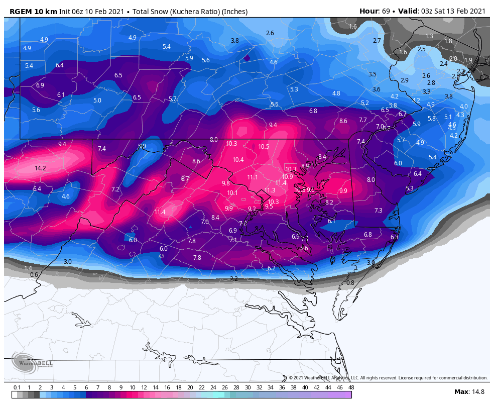
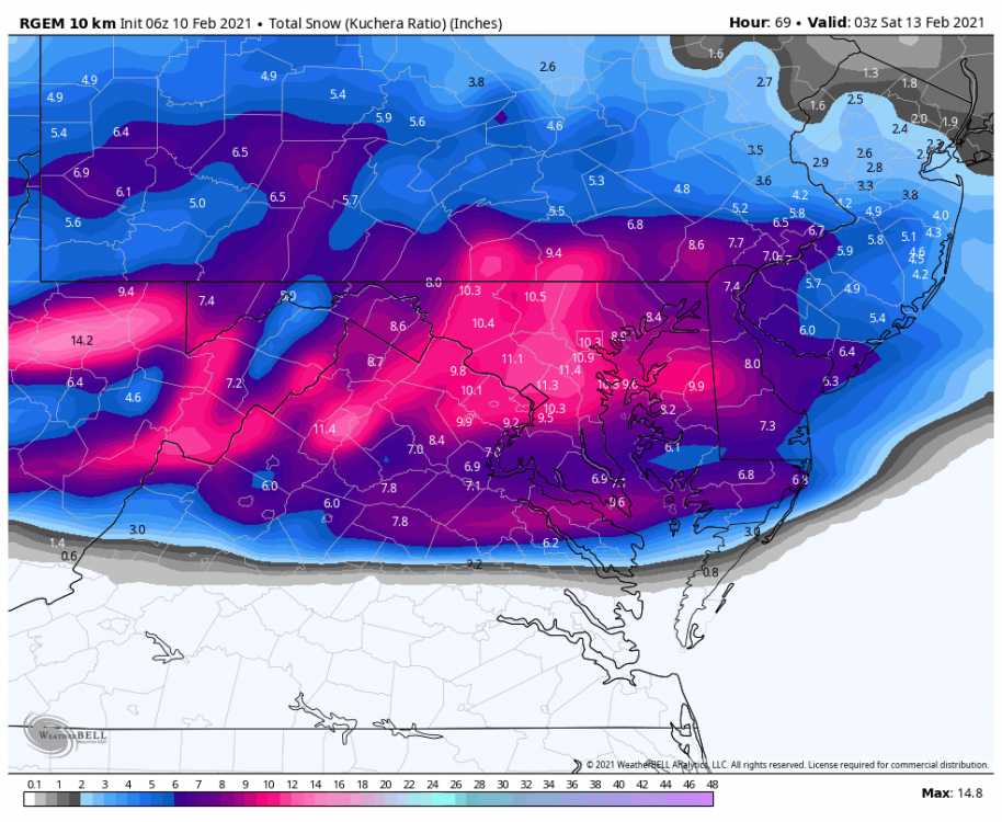
For the great RGEM! At 06z KUCHERA!
-
-
We win round 2? We win round 2? not really... MD wins overall into NW VA in the snow department
-
MD wins round 1 on 06z GFS
-
Snowing in DC at 21 on 06z GFS mix line approaches real quick at 24
-
But he hasn't posted maps yet to prove that
-

Feb Long Range Discussion (Day 3 and beyond) - MERGED
yoda replied to WinterWxLuvr's topic in Mid Atlantic
LWX morning disco... even they are tired lol (note sleep instead of sleet ) -
its like 6 hours of snow lol
-
750mb at KIAD says sorry bud
-
Even for wave 2? DCA goes 31/30/29/28/27 every 3 hours from 42 to 54 on 06z RGEM
-
750mb-850mb +1/+2 on soundings fwiw
-
upper 20s to 30
-
DCA -- 1.1" QPF or so through 57... should be all snow
-
Still snowing at 54
-
MUCH better 06z RGEM run for all on 2nd wave
-
def shift north... mod snow in DC at 45
-
06z RGEM has light snow around DC all day Thursday
-
It is... PW out to 36
-
06z RGEM nice hit for i66 corridor into MD including DC through 27
-
weird site just started on PW
-
Feb Long Range Discussion (Day 3 and beyond) - MERGED
yoda replied to WinterWxLuvr's topic in Mid Atlantic
this doesn't inspire confidence to me -
Feb Long Range Discussion (Day 3 and beyond) - MERGED
yoda replied to WinterWxLuvr's topic in Mid Atlantic
Ji said EPS was a coastal hugger for next week... that still suggests suckiness to me -
Feb Long Range Discussion (Day 3 and beyond) - MERGED
yoda replied to WinterWxLuvr's topic in Mid Atlantic
27/22 and ripping sleet at 84... how nice -
@Deck Pic isn't going to be happy lol
-
URGENT - WINTER WEATHER MESSAGE National Weather Service Baltimore MD/Washington DC 333 AM EST Wed Feb 10 2021 VAZ025-026-036>038-507-508-101645- /O.NEW.KLWX.WW.Y.0009.210211T0000Z-210211T1500Z/ /O.NEW.KLWX.WS.A.0005.210211T2100Z-210212T1500Z/ Augusta-Rockingham-Nelson-Albemarle-Greene- Northern Virginia Blue Ridge-Central Virginia Blue Ridge- 333 AM EST Wed Feb 10 2021 ...WINTER WEATHER ADVISORY IN EFFECT FROM 7 PM THIS EVENING TO 10 AM EST THURSDAY... ...WINTER STORM WATCH IN EFFECT FROM THURSDAY AFTERNOON THROUGH FRIDAY MORNING... * WHAT...For the Winter Weather Advisory, mixed precipitation expected. Total snow accumulations of up to two inches and ice accumulations of a light glaze. For the Winter Storm Watch, heavy snow possible. Total snow accumulations of more than 5 inches possible. * WHERE...Portions of central, northwest and western Virginia. * WHEN...For the Winter Weather Advisory, from 7 PM this evening to 10 AM EST Thursday. For the Winter Storm Watch, from Thursday afternoon through Friday morning. * IMPACTS...Travel could be very difficult. The hazardous conditions could impact the morning or evening commute.