yoda
-
Posts
60,268 -
Joined
Content Type
Profiles
Blogs
Forums
American Weather
Media Demo
Store
Gallery
Everything posted by yoda
-
LWX AFD afternoon update
-
If snow is included. If its just ice, ice storm warning is issued
-
AKQ just went WSWatch for their zones for around a quarter inch of ice... watch is from late Friday night into Saturday evening
-
Would be kind of funny if we get a WSWatch for ice and this time it verifies
-

Feb Long Range Discussion (Day 3 and beyond) - MERGED
yoda replied to WinterWxLuvr's topic in Mid Atlantic
True... but it's better then this snow pattern we were supposedly going into that has turned into a big lie... don't worry though... large cutter brings 50s to near 60 Day 9 -
Feb Long Range Discussion (Day 3 and beyond) - MERGED
yoda replied to WinterWxLuvr's topic in Mid Atlantic
Woof for ice and rain sure -
Feb Long Range Discussion (Day 3 and beyond) - MERGED
yoda replied to WinterWxLuvr's topic in Mid Atlantic
Hmmm... ISW for the weekend coming? -
No lol... total snow accums is what it reads... not additional
-
Feb Long Range Discussion (Day 3 and beyond) - MERGED
yoda replied to WinterWxLuvr's topic in Mid Atlantic
3" of ice in Harrisonburg through 204... closing in on 2 inches in DC -
I'm enjoying my 33 and rain
-
Feb Long Range Discussion (Day 3 and beyond) - MERGED
yoda replied to WinterWxLuvr's topic in Mid Atlantic
At 150 its tight... but its 23 and RIPPING snow at DCA -
Feb Long Range Discussion (Day 3 and beyond) - MERGED
yoda replied to WinterWxLuvr's topic in Mid Atlantic
its light as dry slot comes racing through... pretty much sleet bomb to freezing rain to drizzle -
Feb Long Range Discussion (Day 3 and beyond) - MERGED
yoda replied to WinterWxLuvr's topic in Mid Atlantic
I'll just take the PARA and call it a morning -
Feb Long Range Discussion (Day 3 and beyond) - MERGED
yoda replied to WinterWxLuvr's topic in Mid Atlantic
lol sleet bomb through 156 -
Feb Long Range Discussion (Day 3 and beyond) - MERGED
yoda replied to WinterWxLuvr's topic in Mid Atlantic
mmm... i like banana highs at 144 -
Does it wave 2 us? sort of... but better south
-
Feb Long Range Discussion (Day 3 and beyond) - MERGED
yoda replied to WinterWxLuvr's topic in Mid Atlantic
The cold press is better for us this run Monster sleet in N LA While its 14 degrees... wtf -
Feb Long Range Discussion (Day 3 and beyond) - MERGED
yoda replied to WinterWxLuvr's topic in Mid Atlantic
HP is 3mb stronger at 135 on 06z GFS compared to 141 00z along with being a tad further north -
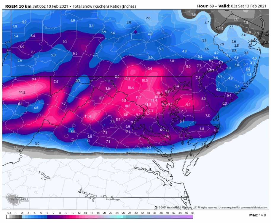
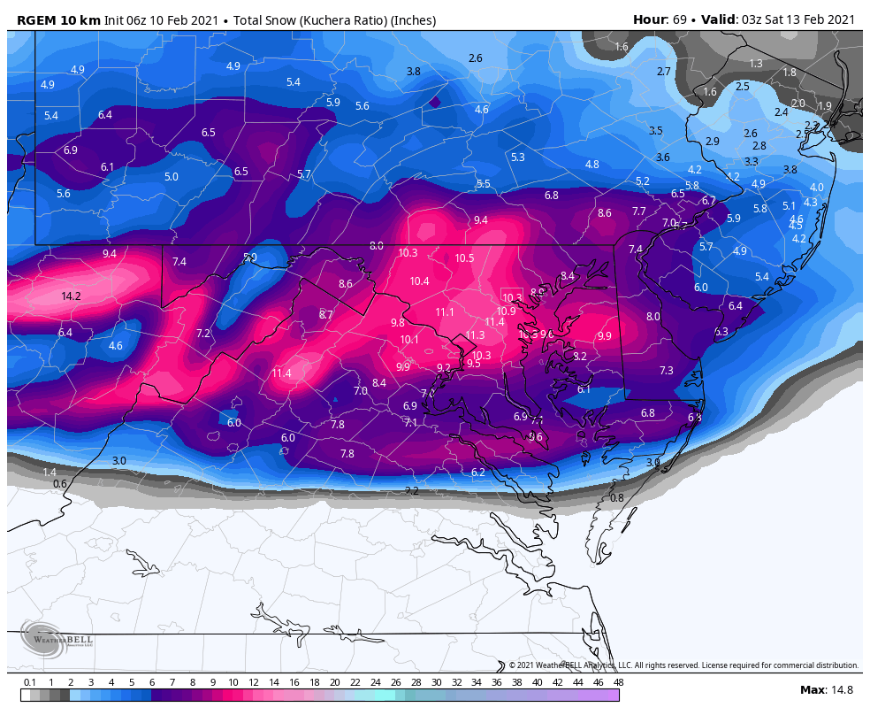
06z PARA is a lil further north with the total snow compared to 00z... but still very nice for the region through 60 -- 4 to 8 inches on Kuchera
-
Feb Long Range Discussion (Day 3 and beyond) - MERGED
yoda replied to WinterWxLuvr's topic in Mid Atlantic
oh ok PARA... I see you at 90 with that heavy snow at DCA -
Feb Long Range Discussion (Day 3 and beyond) - MERGED
yoda replied to WinterWxLuvr's topic in Mid Atlantic
06z PARA starts NW of i95 as snow on SAT at 84 -
Feb Long Range Discussion (Day 3 and beyond) - MERGED
yoda replied to WinterWxLuvr's topic in Mid Atlantic
mainly sleet... RNK/AKQ though get crushed with ice -
06z GFS is cold enough in the entire column... that there is some snow around in N VA into MD at 21z SAT (hour 87) But the majority of the "event" is mid 20s and sleet
-
Wwa 1-3 seems appropriate based on these 2 maps lol... but would rather have LWX go up this time instead of down