

yoda
-
Posts
60,268 -
Joined
Content Type
Profiles
Blogs
Forums
American Weather
Media Demo
Store
Gallery
Everything posted by yoda
-

Feb Long Range Discussion (Day 3 and beyond) - MERGED
yoda replied to WinterWxLuvr's topic in Mid Atlantic
33 and rain at 126 at DCA.... with a +11 850mb T -
Feb Long Range Discussion (Day 3 and beyond) - MERGED
yoda replied to WinterWxLuvr's topic in Mid Atlantic
Rain and 33 at DCA at 120 IAD about to change over -
Feb Long Range Discussion (Day 3 and beyond) - MERGED
yoda replied to WinterWxLuvr's topic in Mid Atlantic
Snow to sleet at 114 at DCA -
Feb Long Range Discussion (Day 3 and beyond) - MERGED
yoda replied to WinterWxLuvr's topic in Mid Atlantic
Probably starts more at 105 tbh -
Feb Long Range Discussion (Day 3 and beyond) - MERGED
yoda replied to WinterWxLuvr's topic in Mid Atlantic
It means you get raked at 108 with ripping heavy snow -
Feb Long Range Discussion (Day 3 and beyond) - MERGED
yoda replied to WinterWxLuvr's topic in Mid Atlantic
Monster ice storm on the 00z UKIE i95 and west... soundings suggest DCA finally goes above 32 at 126... precip starts at like 108 -
Feb Long Range Discussion (Day 3 and beyond) - MERGED
yoda replied to WinterWxLuvr's topic in Mid Atlantic
Boy was that awful lol. Stick to ukmet Here you go Lord Ji -
Feb Long Range Discussion (Day 3 and beyond) - MERGED
yoda replied to WinterWxLuvr's topic in Mid Atlantic
Watching some SW tonight... and I decided to take some weather liberties with some of the scenes... and I'mbored... so here goes Commander of the Weather Weenies: Lord Polar Vortex, this is an unexpected pleasure, we are honored by your presence Lord PV: You may dispense with the weather weenies Commander... I'm here to put your warmer air back on schedule Commander: I assure you Lord PV, my weather weenies are working as fast as they can Lord PV: Perhaps I can find new models to motivate them Commander: I tell you that this southerly jet streak station will be operational as planned Lord PV: The SLP Emperor does not share your optimistic appraisal of the weather situation Commander: But he asks the impossible... I need more weather weenies Lord PV: Then perhaps you can tell the Emperor SLP when he arrives Commander: The SLP is coming here? Lord PV: That is correct Commander, and he is most displeased with the apparent lack of warm air Commander: We shall redouble our efforts Lord PV: I hope so Commander, for your sake... the SLP is not as forgiving as I am -
Should probably tag @Eskimo Joe so that he can see that too... pretty awesome
-
We tried to tell them
-
We would have failed in some different way
-
-FZDZ already here
-
Feb Long Range Discussion (Day 3 and beyond) - MERGED
yoda replied to WinterWxLuvr's topic in Mid Atlantic
73 at ORF at 15z... mid 60s in Ocean City and the Delmarva... much wow -
Feb Long Range Discussion (Day 3 and beyond) - MERGED
yoda replied to WinterWxLuvr's topic in Mid Atlantic
06z GFS says maybe thunderstorms on Friday morning? 60 degrees at DCA at 09z FRI Squall line moves through 12z to 15z FRI across region -
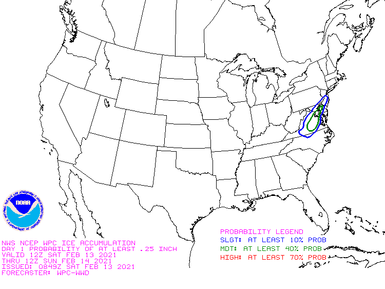
Increase from .1" on earlier advisory to .1-.2" in new one URGENT - WINTER WEATHER MESSAGE National Weather Service Baltimore MD/Washington DC 429 AM EST Sat Feb 13 2021 DCZ001-MDZ003>006-008-011-013-014-502>508-VAZ028-031-052>054-501- 505-506-WVZ051>053-131730- /O.CON.KLWX.WW.Y.0011.210213T1200Z-210214T1200Z/ District of Columbia-Washington-Frederick MD-Carroll- Northern Baltimore-Cecil-Southern Baltimore-Prince Georges- Anne Arundel-Central and Eastern Allegany-Northwest Montgomery- Central and Southeast Montgomery-Northwest Howard- Central and Southeast Howard-Northwest Harford-Southeast Harford- Frederick VA-Clarke-Prince William/Manassas/Manassas Park-Fairfax- Arlington/Falls Church/Alexandria-Northern Fauquier- Western Loudoun-Eastern Loudoun-Morgan-Berkeley-Jefferson- 429 AM EST Sat Feb 13 2021 ...WINTER WEATHER ADVISORY REMAINS IN EFFECT UNTIL 7 AM EST SUNDAY... * WHAT...Predominantly sleet and freezing rain, possibly mixed with snow in northern Maryland. Snow and sleet accumulation of less than one inch and ice accumulations of one tenth to two tenths of an inch. * WHERE...The District of Columbia, much of central and western Maryland, portions of northern and northwest Virginia and the eastern panhandle of West Virginia. * WHEN...Until 7 AM EST Sunday. * IMPACTS...Plan on slippery road conditions.
-
Calvert county added to ISW
-
-
Wouldn't be surprised if we see ISW appear in i95 corridor if 00z models look like 00z NAM
-
Feb Long Range Discussion (Day 3 and beyond) - MERGED
yoda replied to WinterWxLuvr's topic in Mid Atlantic
18z GFS looks pretty icy at 84-90 across much of the region -
Eexcept for the ISW in S MD and EZF area
-
Feb Long Range Discussion (Day 3 and beyond) - MERGED
yoda replied to WinterWxLuvr's topic in Mid Atlantic
well NAM twins brought it back for the most part... not severe... but still couple tenths -
Feb Long Range Discussion (Day 3 and beyond) - MERGED
yoda replied to WinterWxLuvr's topic in Mid Atlantic
i dunno... that para GFS/GFS/ICON combo is pretty mean -
Feb Long Range Discussion (Day 3 and beyond) - MERGED
yoda replied to WinterWxLuvr's topic in Mid Atlantic
06z GFS also has an ice to dryslot event all day Thursday which later turns into "rains to Maine" Friday with 51 at DCA and heavy rain -
Feb Long Range Discussion (Day 3 and beyond) - MERGED
yoda replied to WinterWxLuvr's topic in Mid Atlantic
06z Para GFS agrees with 06z GFS and kicks out the wave in full swoop... late Monday night into Tuesday morning major ice storm... slams i81 to i95 corridor with 0.4-0.8" ice as well -
Feb Long Range Discussion (Day 3 and beyond) - MERGED
yoda replied to WinterWxLuvr's topic in Mid Atlantic
0.4"-0.8" ice... nice lol... mainly centered along i95 corridor as well


