yoda
-
Posts
63,195 -
Joined
Content Type
Profiles
Blogs
Forums
American Weather
Media Demo
Store
Gallery
Everything posted by yoda
-

2022 Mid-Atlantic Severe Wx Thread (General Discussion Etc)
yoda replied to Kmlwx's topic in Mid Atlantic
Thought it a bit odd as well, guess they could mention it on the 2000z OTLK if the threat manifests itself? -
2022 Mid-Atlantic Severe Wx Thread (General Discussion Etc)
yoda replied to Kmlwx's topic in Mid Atlantic
I hope he has collision insurance on that -
2022 Mid-Atlantic Severe Wx Thread (General Discussion Etc)
yoda replied to Kmlwx's topic in Mid Atlantic
Severe Weather Statement National Weather Service Baltimore MD/Washington DC 1231 PM EDT Fri May 27 2022 MDC027-031-271640- /O.CAN.KLWX.TO.W.0013.000000T0000Z-220527T1645Z/ Howard MD-Montgomery MD- 1231 PM EDT Fri May 27 2022 ...THE TORNADO WARNING FOR SOUTHEASTERN HOWARD AND EAST CENTRAL MONTGOMERY COUNTIES IS CANCELLED... The storm which prompted the warning has moved out of the area. Therefore, the warning has been cancelled. A Tornado Watch remains in effect until 200 PM EDT for central Maryland. A Tornado Warning still remains in effect for portions of Montgomery and Howard Counties as the circulation observed on radar moved west of the orginal Tornado Warning. -
2022 Mid-Atlantic Severe Wx Thread (General Discussion Etc)
yoda replied to Kmlwx's topic in Mid Atlantic
Interesting... LWX had to reissue the Tornado Warning for Montgomery and Howard because the circulation went outside their original warning polygon by moving westward -
2022 Mid-Atlantic Severe Wx Thread (General Discussion Etc)
yoda replied to Kmlwx's topic in Mid Atlantic
short term for supercells -
2022 Mid-Atlantic Severe Wx Thread (General Discussion Etc)
yoda replied to Kmlwx's topic in Mid Atlantic
1630z OTLK should be an interesting read in a few -
2022 Mid-Atlantic Severe Wx Thread (General Discussion Etc)
yoda replied to Kmlwx's topic in Mid Atlantic
Tornado Warning for North Central Carroll County -
2022 Mid-Atlantic Severe Wx Thread (General Discussion Etc)
yoda replied to Kmlwx's topic in Mid Atlantic
-
2022 Mid-Atlantic Severe Wx Thread (General Discussion Etc)
yoda replied to Kmlwx's topic in Mid Atlantic
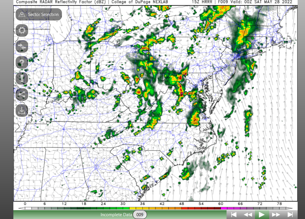
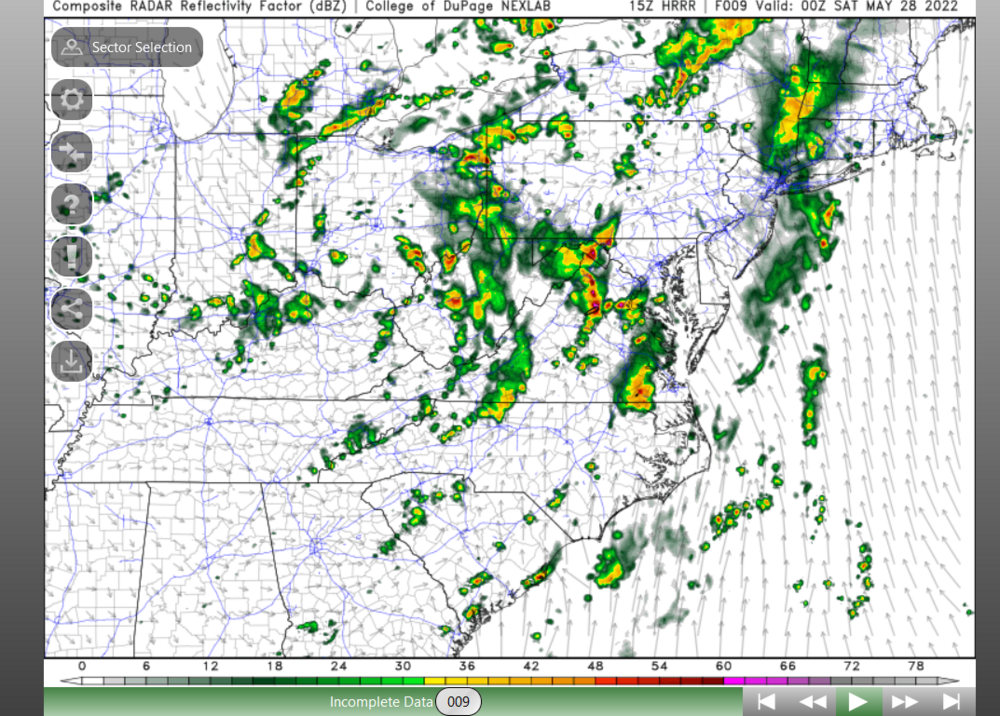
Um yeah... that looks like sups on the 15z HRRR arriving in DC metro at 00z/01z, no? -
2022 Mid-Atlantic Severe Wx Thread (General Discussion Etc)
yoda replied to Kmlwx's topic in Mid Atlantic
Tornado Warning for Howard and Montgomery counties -
2022 Mid-Atlantic Severe Wx Thread (General Discussion Etc)
yoda replied to Kmlwx's topic in Mid Atlantic
So far, 15z HRRR is looking really intriguing on the sim radar at 22z... -
2022 Mid-Atlantic Severe Wx Thread (General Discussion Etc)
yoda replied to Kmlwx's topic in Mid Atlantic
see @MN Transplant post above of the TDR from DCA -
2022 Mid-Atlantic Severe Wx Thread (General Discussion Etc)
yoda replied to Kmlwx's topic in Mid Atlantic
Yup, SWS says circulation has weakened -
2022 Mid-Atlantic Severe Wx Thread (General Discussion Etc)
yoda replied to Kmlwx's topic in Mid Atlantic
BULLETIN - IMMEDIATE BROADCAST REQUESTED Severe Thunderstorm Warning National Weather Service Baltimore MD/Washington DC 1159 AM EDT Fri May 27 2022 The National Weather Service in Sterling Virginia has issued a * Severe Thunderstorm Warning for... Central Carroll County in north central Maryland... Northwestern Howard County in central Maryland... Northwestern Montgomery County in central Maryland... Frederick County in north central Maryland... * Until 1245 PM EDT. * At 1159 AM EDT, severe thunderstorms were located along a line extending from near Walkersville to near Ballenger Creek to near Poolesville, moving east at 30 mph. HAZARD...60 mph wind gusts. SOURCE...Radar indicated. IMPACT...Damaging winds will cause some trees and large branches to fall. This could injure those outdoors, as well as damage homes and vehicles. Roadways may become blocked by downed trees. Localized power outages are possible. Unsecured light objects may become projectiles. * Locations impacted include... Germantown, Frederick, Westminster, Damascus, Thurmont, Poolesville, Harry Grove Stadium, Montgomery Village, Eldersburg, Ballenger Creek, Mount Airy, Taneytown, Walkersville, Braddock Heights, New Market, Green Valley, Clover Hill, Discovery-Spring Garden, Boyds and Linganore-Bartonsville. -
2022 Mid-Atlantic Severe Wx Thread (General Discussion Etc)
yoda replied to Kmlwx's topic in Mid Atlantic
Nice catch... tornado warned now -
2022 Mid-Atlantic Severe Wx Thread (General Discussion Etc)
yoda replied to Kmlwx's topic in Mid Atlantic
Covers east and SE of us... no counties from LWX in that new watchbox -
2022 Mid-Atlantic Severe Wx Thread (General Discussion Etc)
yoda replied to Kmlwx's topic in Mid Atlantic
BULLETIN - IMMEDIATE BROADCAST REQUESTED Severe Thunderstorm Warning National Weather Service Baltimore MD/Washington DC 1143 AM EDT Fri May 27 2022 The National Weather Service in Sterling Virginia has issued a * Severe Thunderstorm Warning for... Southwestern Prince Georges County in central Maryland... Northwestern Charles County in southern Maryland... Central Stafford County in northern Virginia... Southeastern Fairfax County in northern Virginia... Southeastern Prince William County in northern Virginia... * Until 1230 PM EDT. * At 1142 AM EDT, severe thunderstorms were located along a line extending from near Montclair to near Stafford to near Fredericksburg, moving east at 35 mph. HAZARD...60 mph wind gusts. SOURCE...Radar indicated. IMPACT...Damaging winds will cause some trees and large branches to fall. This could injure those outdoors, as well as damage homes and vehicles. Roadways may become blocked by downed trees. Localized power outages are possible. Unsecured light objects may become projectiles. * Locations impacted include... Stafford, Waldorf, Dale City, Clinton, Fort Washington, Fort Hunt, La Plata, Fort Belvoir, Woodbridge, Quantico, Aquia Creek, Port Tobacco River, Lake Ridge, Montclair, Lorton, Hybla Valley, Newington, Friendly, Triangle and Dumfries. -
2022 Mid-Atlantic Severe Wx Thread (General Discussion Etc)
yoda replied to Kmlwx's topic in Mid Atlantic
Don't know if I am using it right, but some of the higher tilts (like Tilt 3) on Radarscope look like they have some decent rotation down in EZF and in Prince William County using SRV (Storm Relative Velocity) -
2022 Mid-Atlantic Severe Wx Thread (General Discussion Etc)
yoda replied to Kmlwx's topic in Mid Atlantic
11am LWX HRR says partly sunny skies too -
2022 Mid-Atlantic Severe Wx Thread (General Discussion Etc)
yoda replied to Kmlwx's topic in Mid Atlantic
If it continues NE path... could brush eastern DC metro in about an hour -
2022 Mid-Atlantic Severe Wx Thread (General Discussion Etc)
yoda replied to Kmlwx's topic in Mid Atlantic
Updated morning AFD from LWX (as of 1025am) says that the afternoon/evening threat for severe is "still in play" .NEAR TERM /THROUGH TONIGHT/... Initial line associated with low level jet continues to slowly move eastward across the area. Tornado Watch remains in place through 2 PM. Some stabilization has been occurring with northward extent as storms interact with weaker instability and more CIN across our forecast area. Appears an effective warm front is lurking between DC and Fredericksburg, and theta-e advection along with some diurnal heating will result in higher instability spreading northward ahead of the line as it reaches the I-95 corridor during the midday hours. Therefore damaging winds and a brief tornado remain threats as low level shear values remain high. While the overall line will progress to the east, there is potential for brief training and we have seen rain amounts of 1-2 inches in an hour where this occurs. The second round late this afternoon and into this evening is still somewhat uncertain, but additional severe storms and localized flooding issues are still within play. -
2022 Mid-Atlantic Severe Wx Thread (General Discussion Etc)
yoda replied to Kmlwx's topic in Mid Atlantic
BULLETIN - IMMEDIATE BROADCAST REQUESTED Severe Thunderstorm Warning National Weather Service Baltimore MD/Washington DC 1107 AM EDT Fri May 27 2022 The National Weather Service in Sterling Virginia has issued a * Severe Thunderstorm Warning for... Western Loudoun County in northern Virginia... Northeastern Warren County in northwestern Virginia... Clarke County in northwestern Virginia... Northwestern Fauquier County in northern Virginia... Southeastern Jefferson County in the Panhandle of West Virginia... * Until 1145 AM EDT. * At 1107 AM EDT, severe thunderstorms were located along a line extending from near Millwood Pike to 7 miles south of Berryville to Hume, moving northeast at 40 mph. HAZARD...60 mph wind gusts. SOURCE...Radar indicated. IMPACT...Damaging winds will cause some trees and large branches to fall. This could injure those outdoors, as well as damage homes and vehicles. Roadways may become blocked by downed trees. Localized power outages are possible. Unsecured light objects may become projectiles. * Locations impacted include... Purcellville, Berryville, Middleburg, Round Hill, Delaplane, Linden, Oatlands, Bluemont, Lovettsville, Boyce, Hamilton, Hillsboro, White Post, Gaylord, Aldie, Blue Mountain, Philomont, Bethel, Lincoln and Saint Louis. PRECAUTIONARY/PREPAREDNESS ACTIONS... A Tornado Watch remains in effect until 200 PM EDT for north central Maryland...northern and northwestern Virginia...and the Panhandle of West Virginia. For your protection move to an interior room on the lowest floor of a building. -
2022 Mid-Atlantic Severe Wx Thread (General Discussion Etc)
yoda replied to Kmlwx's topic in Mid Atlantic
I'm sorry, as an aside, I love the city name Bumpass. -
2022 Mid-Atlantic Severe Wx Thread (General Discussion Etc)
yoda replied to Kmlwx's topic in Mid Atlantic
AKQ canceled the TW -
2022 Mid-Atlantic Severe Wx Thread (General Discussion Etc)
yoda replied to Kmlwx's topic in Mid Atlantic
Latest RWR as of 10am shows 70 degree DPs reaching just south of DC