yoda
-
Posts
60,268 -
Joined
Content Type
Profiles
Blogs
Forums
American Weather
Media Demo
Store
Gallery
Everything posted by yoda
-
Trained spotter reported funnel cloud 4 SSE EZF per LSR
-
Confirmed TOG in N WV with the storms out there
-
Hail core in PG County showed up quickly
-
Probably... but radar is lighting up out there with STW and TWs... so something to watch for later I guess. Front is still way out west
-
Severe Weather Statement National Weather Service Baltimore MD/Washington DC 537 PM EDT Thu Jul 29 2021 DCC001-MDC003-009-033-292230- /O.CON.KLWX.SV.W.0316.000000T0000Z-210729T2230Z/ District of Columbia DC-Anne Arundel MD-Calvert MD-Prince Georges MD- 537 PM EDT Thu Jul 29 2021 ...A SEVERE THUNDERSTORM WARNING REMAINS IN EFFECT UNTIL 630 PM EDT FOR THE EAST CENTRAL DISTRICT OF COLUMBIA...SOUTH CENTRAL ANNE ARUNDEL...NORTHWESTERN CALVERT AND EAST CENTRAL PRINCE GEORGES COUNTIES... At 537 PM EDT, a severe thunderstorm was located over Carmody Hills-Pepper Mill Village, or over Fedex Field, moving southeast at 20 mph. HAZARD...Ping pong ball size hail and 60 mph wind gusts. SOURCE...Radar indicated. IMPACT...Damaging winds will cause some trees and large branches to fall. This could injure those outdoors, as well as damage homes and vehicles. Roadways may become blocked by downed trees. Localized power outages are possible. Unsecured light objects may become projectiles. Locations impacted include... Bowie, Clinton, Forestville, Largo, Coral Hills, Shady Side, Chesapeake Beach, Deale, Upper Marlboro, Breezy Point, Fedex Field, RFK Stadium, Andrews Air Force Base, Landover, Camp Springs, Kettering, New Carrollton, Walker Mill, Mitchellville and Rosaryville.
-
What do we think of the stuff back in OH and PA?
-
Tornado warning for AA County canceled due to weaker rotation
-
Severe Weather Statement National Weather Service Baltimore MD/Washington DC 517 PM EDT Thu Jul 29 2021 MDC017-VAC061-099-153-179-292200- /O.CON.KLWX.SV.W.0313.000000T0000Z-210729T2200Z/ Charles MD-Stafford VA-King George VA-Fauquier VA-Prince William VA- 517 PM EDT Thu Jul 29 2021 ...A SEVERE THUNDERSTORM WARNING REMAINS IN EFFECT UNTIL 600 PM EDT FOR WESTERN CHARLES...STAFFORD...NORTHWESTERN KING GEORGE... SOUTHEASTERN FAUQUIER AND SOUTHEASTERN PRINCE WILLIAM COUNTIES... At 517 PM EDT, a severe thunderstorm was located 9 miles northwest of Stafford, moving east at 25 mph. This is a very dangerous storm. HAZARD...80 mph wind gusts and tennis ball size hail. SOURCE...Radar indicated. IMPACT...Expect considerable damage to trees and power lines. Your life is at significant risk if outdoors. In addition to some trees falling into homes, wind damage is possible to roofs, sheds, open garages, and mobile homes. Locations impacted include... Stafford, Quantico, Potomac Creek, Aquia Creek, Triangle, Dumfries, Cherry Hill, Widewater, Roseville, Garrisonville, Arkendale, Brooke, Ramoth, Heflin, Aquia, Storck, Glendie, Hartwood, Ruby and Somerville. PRECAUTIONARY/PREPAREDNESS ACTIONS... For your protection move to an interior room on the lowest floor of a building. This is an EXTREMELY DANGEROUS SITUATION with tornado like wind speeds possible. Mobile homes and high profile vehicles are especially susceptible to winds of this magnitude and may be overturned. For your protection move to an interior room on the lowest floor of a building. This storm has the potential to cause serious injury and significant property damage. && LAT...LON 3839 7763 3841 7764 3858 7762 3856 7726 3848 7727 3850 7728 3848 7728 3833 7729 TIME...MOT...LOC 2117Z 284DEG 23KT 3850 7753 HAIL...2.50IN WIND...80MPH
-
ULLETIN - EAS ACTIVATION REQUESTED Severe Thunderstorm Warning National Weather Service Baltimore MD/Washington DC 521 PM EDT Thu Jul 29 2021 The National Weather Service in Sterling Virginia has issued a * Severe Thunderstorm Warning for... Southern Stafford County in northern Virginia... Central King George County in central Virginia... The City of Fredericksburg in central Virginia... Northeastern Spotsylvania County in central Virginia... * Until 600 PM EDT. * At 520 PM EDT, a potentially destructive severe thunderstorm was located near Fredericksburg, moving southeast at 35 mph. This is a very dangerous storm. HAZARD...Two inch hail and 75 mph wind gusts. SOURCE...Radar indicated. IMPACT...Expect considerable damage to trees and power lines. Your life is at significant risk if outdoors. In addition to some trees falling into homes, wind damage is possible to roofs, sheds, open garages, and mobile homes. * Locations impacted include... Stafford, Fredericksburg, King George, Fairview Beach, Massaponax, Spotsylvania, Falmouth, Passapatanzy, Stones Corner, Roseville, Ramoth, Thornburg, White Oak, Sealston, Jersey, Dogue, Leeland, Rollins Fork, Spring Valley and Brooke. PRECAUTIONARY/PREPAREDNESS ACTIONS... For your protection move to an interior room on the lowest floor of a building. This is a potentially DANGEROUS SITUATION with tornado like wind speeds possible. Mobile homes and high profile vehicles are especially susceptible to winds of this magnitude and may be overturned. For your protection move to an interior room on the lowest floor of a building. This storm has the potential to cause serious injury and significant property damage. && LAT...LON 3836 7766 3838 7764 3836 7764 3837 7762 3839 7763 3850 7752 3820 7704 3816 7707 3815 7707 3816 7709 3816 7717 3820 7722 3819 7725 3823 7725 3825 7723 3825 7727 3822 7729 3824 7729 3825 7735 3809 7754 TIME...MOT...LOC 2120Z 309DEG 29KT 3839 7752 HAIL...2.00IN WIND...70MPH
-
Never seen LWX use the "potentially destructive severe thunderstorm" wording before
-
Strongest SWS I've seen LWX issue since the derecho
-
Looks hooky down by Goldvien
-
Um... no thanks Severe Weather Statement National Weather Service Baltimore MD/Washington DC 506 PM EDT Thu Jul 29 2021 MDC017-VAC061-099-153-179-292200- /O.CON.KLWX.SV.W.0313.000000T0000Z-210729T2200Z/ Charles MD-Stafford VA-King George VA-Fauquier VA-Prince William VA- 506 PM EDT Thu Jul 29 2021 ...A SEVERE THUNDERSTORM WARNING REMAINS IN EFFECT UNTIL 600 PM EDT FOR WESTERN CHARLES...STAFFORD...NORTHWESTERN KING GEORGE... SOUTHEASTERN FAUQUIER AND SOUTHEASTERN PRINCE WILLIAM COUNTIES... At 505 PM EDT, a potentially destructive severe thunderstorm was located 9 miles southeast of Bealeton, or 14 miles northwest of Stafford, moving east at 25 mph. This is a very dangerous storm. HAZARD...80 mph wind gusts and tennis ball size hail. SOURCE...Radar indicated. IMPACT...Expect considerable damage to trees and power lines. Your life is at significant risk if outdoors. In addition to some trees falling into homes, wind damage is possible to roofs, sheds, open garages, and mobile homes. Locations impacted include... Stafford, Quantico, Potomac Creek, Aquia Creek, Triangle, Dumfries, Cherry Hill, Midland, Roseville, Garrisonville, Ramoth, Heflin, Morrisville, Ruby, Somerville, Goldvein, Widewater, Lois, Arkendale and Brooke. PRECAUTIONARY/PREPAREDNESS ACTIONS... This is an EXTREMELY DANGEROUS SITUATION with tornado like wind speeds possible. Mobile homes and high profile vehicles are especially susceptible to winds of this magnitude and may be overturned. For your protection move to an interior room on the lowest floor of a building. This storm has the potential to cause serious injury and significant property damage. This storm is producing destructive winds and large damaging hail. SEEK SHELTER NOW inside a sturdy structure and stay away from windows. && LAT...LON 3839 7763 3841 7764 3846 7776 3858 7771 3856 7726 3848 7727 3850 7728 3848 7728 3833 7729 TIME...MOT...LOC 2105Z 284DEG 23KT 3852 7763 HAIL...2.50IN WIND...80MPH
-
Severe Thunderstorm Warning MDC017-VAC061-099-153-179-292200- /O.NEW.KLWX.SV.W.0313.210729T2059Z-210729T2200Z/ BULLETIN - IMMEDIATE BROADCAST REQUESTED Severe Thunderstorm Warning National Weather Service Baltimore MD/Washington DC 459 PM EDT Thu Jul 29 2021 The National Weather Service in Sterling Virginia has issued a * Severe Thunderstorm Warning for... Western Charles County in southern Maryland... Stafford County in northern Virginia... Northwestern King George County in central Virginia... Southeastern Fauquier County in northern Virginia... Southeastern Prince William County in northern Virginia... * Until 600 PM EDT. * At 458 PM EDT, a severe thunderstorm was located near Bealeton, or 14 miles southeast of Warrenton, moving east at 25 mph. HAZARD...Golf ball size hail and 75 mph wind gusts. SOURCE...Radar indicated. IMPACT...Expect wind damage to trees and power lines. Hail is large enough to dent and damage vehicles. Some hail damage to roofs, siding, and windows is possible. * Locations impacted include... Stafford, Quantico, Potomac Creek, Aquia Creek, Triangle, Dumfries, Bealeton, Cherry Hill, Roseville, Garrisonville, Ramoth, Heflin, Morrisville, Ruby, Somerville, Goldvein, Widewater, Lois, Arkendale and Brooke. PRECAUTIONARY/PREPAREDNESS ACTIONS... This storm is producing destructive winds and large damaging hail. SEEK SHELTER NOW inside a sturdy structure and stay away from windows!
-
Huge hail core in S Fauquier
-
That warning for the other N VA storm... yikes
-
Pouring here in Fairfax
-
Now I want crab cakes for dinner
-
Wouldn't be surprised if something was on the ground...
-
@Mrs.J is up there no? Or is that @psuhoffman?
-
Just got warned
-
SWS for Carroll County cell in MD talking it up about being extremely dangerous
-
Wonder if on the 1300z SPC OTLK they nudge the ENH risk SW some to include a bit more of N VA into C VA
-
06z NAM sounding at BWI at 00z tonight is
-
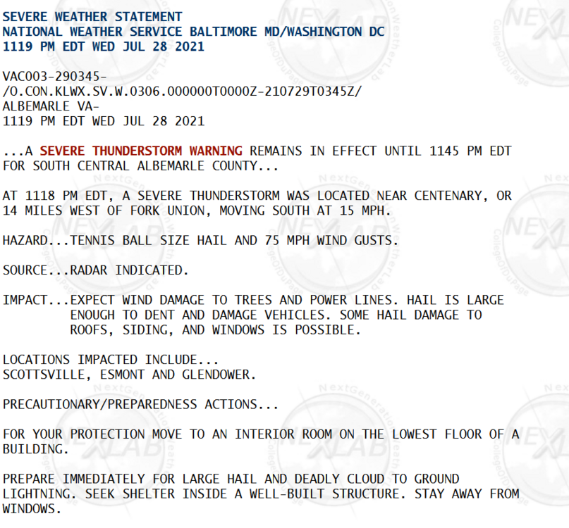
Don't see these from LWX too often... from last night... SWS for Albermarle County