yoda
-
Posts
60,268 -
Joined
Content Type
Profiles
Blogs
Forums
American Weather
Media Demo
Store
Gallery
Everything posted by yoda
-
With showers too
-
Saw this on FB and yeah... @WxWatcher007
-
Tropical Storm Victor Discussion Number 4 NWS National Hurricane Center Miami FL AL202021 800 AM CVT Thu Sep 30 2021 Victor is gradually getting better organized. AMSR2 microwave data from 0300 UTC showed that the low-level circulation has become more defined, with most convective banding features located west and southwest of the center. Victor's intensity is now estimated to be 40 kt based on Dvorak estimates of T3.0 and T2.5 from TAFB and SAB, respectively, and objective numbers from UW-CIMSS around 40 kt. Victor's vector is toward the west-northwest (290 degrees) at 11 kt, and this heading should continue for the next 36 hours while the storm is located to the south a deep-layer ridge located over the subtropical eastern and central Atlantic. In about 2 days, a mid- to upper-level low is forecast to develop over the central Atlantic, causing Victor to curve around the western periphery of the ridge, which gets shunted eastward between the Azores and the Canary Islands. The track models are in generally good agreement on this scenario, and most of them are clustered tightly among each other. Two notable exceptions, which are discounted at this time, are the HWRF and ECMWF models. The HWRF, which is stronger than the other models, is way off to the east, while the ECMWF lies off to the south and west, a tendency that we've observed recently with other storms in the deep tropics. The NHC track forecast is not changed much from the previous iteration and lies close to the GFS, HCCA, Florida State Superensemble, and TVCA solutions. If the low-level circulation is in fact becoming better defined as shown by microwave imagery, Victor should be able to continue strengthening for the next couple of days in an environment of low vertical shear and over warm waters of roughly 28 degrees Celsius. The NHC intensity forecast is near the upper end of the guidance during this period and continues to show Victor reaching hurricane strength in about 36 hours. Once the aforementioned mid- to upper-level low forms, strong southerly to southwesterly deep-layer shear is expected to develop over Victor and induce a weakening trend in about 3 days. The intensity forecast has been lowered a bit during the latter part of the forecast period given the trends in the intensity models, but it is not as low as the HCCA and IVCN aids. Interestingly, many of the global models suggest that the shear could be so strong that Victor might weaken to a depression or even degenerate into a remnant low by day 5. FORECAST POSITIONS AND MAX WINDS INIT 30/0900Z 8.7N 27.3W 40 KT 45 MPH 12H 30/1800Z 9.4N 28.8W 50 KT 60 MPH 24H 01/0600Z 10.2N 30.6W 60 KT 70 MPH 36H 01/1800Z 11.2N 32.3W 65 KT 75 MPH 48H 02/0600Z 12.6N 33.8W 65 KT 75 MPH 60H 02/1800Z 14.4N 35.3W 60 KT 70 MPH 72H 03/0600Z 16.6N 37.0W 55 KT 65 MPH 96H 04/0600Z 22.0N 40.2W 40 KT 45 MPH 120H 05/0600Z 27.3N 41.9W 35 KT 40 MPH $$ Forecaster Berg
-
BULLETIN Tropical Storm Victor Advisory Number 4 NWS National Hurricane Center Miami FL AL202021 800 AM CVT Thu Sep 30 2021 ...VICTOR A LITTLE STRONGER... SUMMARY OF 800 AM CVT...0900 UTC...INFORMATION ---------------------------------------------- LOCATION...8.7N 27.3W ABOUT 550 MI...885 KM SSW OF THE CABO VERDE ISLANDS MAXIMUM SUSTAINED WINDS...45 MPH...75 KM/H PRESENT MOVEMENT...WNW OR 290 DEGREES AT 13 MPH...20 KM/H MINIMUM CENTRAL PRESSURE...1004 MB...29.65 INCHES WATCHES AND WARNINGS -------------------- There are no coastal watches or warnings in effect. DISCUSSION AND OUTLOOK ---------------------- At 800 AM CVT (0900 UTC), the center of Tropical Storm Victor was located near latitude 8.7 North, longitude 27.3 West. Victor is moving toward the west-northwest near 13 mph (20 km/h). A west-northwest to northwest motion over the eastern tropical Atlantic is expected through the weekend. Maximum sustained winds have increased to near 45 mph (75 km/h) with higher gusts. Additional strengthening is forecast, and Victor could become a hurricane on Friday. A weakening trend is expected to begin over the weekend. Tropical-storm-force winds extend outward up to 60 miles (95 km) from the center. The estimated minimum central pressure is 1004 mb (29.65 inches). HAZARDS AFFECTING LAND ---------------------- None NEXT ADVISORY ------------- Next complete advisory at 200 PM CVT. $$ Forecaster Berg
-
Hurricane Sam Discussion Number 31 NWS National Hurricane Center Miami FL AL182021 500 AM AST Thu Sep 30 2021 Sam is a very impressive hurricane in infrared satellite imagery this morning. The 25-nm-wide eye remains very distinct and is surrounded by a ring of convection with cloud tops around -65C. The outflow is also well established in all quadrants. An Air Force Reserve Hurricane Hunter aircraft that performed three eyewall penetrations overnight has reported peak 700-mb flight-level winds of 139 kt in the northeastern, southeastern, and eastern eyewall, and peak SFMR surface winds of 119 kt. These data still support an initial wind speed of 125 kt. Sam's minimum pressure has fallen a few millibars since the NOAA aircraft mission last evening. The latest estimated pressure from dropsonde data gathered by the Air Force is 937 mb. NOAA buoy 41044 has recently reported a peak one-minute wind of 68 kt with a gust to 86 kt in the northeastern eyewall of Sam. The buoy has also reported peak seas of 40 ft. Sam could still strengthen a little today as it continues to move over a warm ocean eddy and remains in low vertical wind shear conditions. After that time, difficult-to-predict eyewall cycles however, could cause some fluctuations in intensity. After 48 hours, gradually decreasing SSTs and ocean heat content are likely to cause a more definitive weakening trend, with a faster rate of weakening likely after day 3. Sam is forecast to complete its extratropical transition by day 5, and it is predicted by the global model guidance to become a large and powerful extratropical low over the north Atlantic. Sam is moving northwestward or 320/10 kt. The track forecast reasoning is again unchanged from the previous advisory. Sam will move northwestward, and then northward around the western portion of a subtropical ridge during the next 48 hours. After that time, Sam is predicted to turn northeastward between the ridge and a large mid-latitude trough over the northeastern United States. As that trough lifts northeastward by day 3, Sam is forecast to continue on a northeastward heading, but it is not likely to accelerate as much as a typical recurving tropical cyclone over the north-central Atlantic. The dynamical model guidance remains in excellent agreement through 72 hours, but there is increasing spread after that time. The latest runs of the GFS and ECMWF models have come into somewhat better agreement at days 3 through 5, and the NHC track forecast is near the consensus of those typically reliable models. Although the core of Sam is forecast to pass east of Bermuda early Saturday, the tropical-storm-force wind field is forecast to expand and could pass very close to the island beginning late Friday night or early Saturday. Therefore, the Bermuda Weather Service has issued a Tropical Storm Watch for Bermuda. Key Messages: 1. Swells generated by Sam will impact the Northern Leeward Islands and the Greater Antilles, including Puerto Rico, during the next few days. Swells are expected to reach Bermuda and the Bahamas by Friday, and then spread to the United States east coast by this weekend. These swells could cause life-threatening surf and rip current conditions. Please consult products from your local weather office. 2. Tropical storm conditions are possible on Bermuda beginning Friday night or early Saturday, and a Tropical Storm Watch has been issued for that island. FORECAST POSITIONS AND MAX WINDS INIT 30/0900Z 21.5N 59.1W 125 KT 145 MPH 12H 30/1800Z 23.0N 60.2W 130 KT 150 MPH 24H 01/0600Z 25.6N 61.4W 125 KT 145 MPH 36H 01/1800Z 28.4N 61.8W 120 KT 140 MPH 48H 02/0600Z 31.1N 61.3W 115 KT 130 MPH 60H 02/1800Z 33.5N 59.9W 105 KT 120 MPH 72H 03/0600Z 35.5N 58.0W 95 KT 110 MPH 96H 04/0600Z 38.7N 52.6W 80 KT 90 MPH 120H 05/0600Z 44.3N 45.0W 65 KT 75 MPH...POST-TROP/EXTRATROP $$ Forecaster Brown
-
BULLETIN Hurricane Sam Advisory Number 31 NWS National Hurricane Center Miami FL AL182021 500 AM AST Thu Sep 30 2021 ...POWERFUL HURRICANE SAM CONTINUES NORTHWESTWARD... ...TROPICAL STORM WATCH ISSUED FOR BERMUDA... SUMMARY OF 500 AM AST...0900 UTC...INFORMATION ---------------------------------------------- LOCATION...21.5N 59.1W ABOUT 345 MI...555 KM NE OF THE NORTHERN LEEWARD ISLANDS ABOUT 825 MI...1325 KM SSE OF BERMUDA MAXIMUM SUSTAINED WINDS...145 MPH...230 KM/H PRESENT MOVEMENT...NW OR 320 DEGREES AT 12 MPH...19 KM/H MINIMUM CENTRAL PRESSURE...937 MB...27.67 INCHES WATCHES AND WARNINGS -------------------- CHANGES WITH THIS ADVISORY: The Bermuda Weather Service has issued a Tropical Storm Watch for Bermuda. SUMMARY OF WATCHES AND WARNINGS IN EFFECT: A Tropical Storm Watch is in effect for... * Bermuda A Tropical Storm Watch means that tropical storm conditions are possible within the watch area, generally within 48 hours. For storm information specific to your area, please monitor products issued by your national meteorological service. DISCUSSION AND OUTLOOK ---------------------- At 500 AM AST (0900 UTC), the eye of Hurricane Sam was located near latitude 21.5 North, longitude 59.1 West. Sam is moving toward the northwest near 12 mph (19 km/h), and this general motion with an increase in forward speed is expected through tonight. A turn toward the north is anticipated by late Friday, and a northeastward motion is forecast to begin on Saturday. On the forecast track, the core of Sam will continue to pass well to the northeast of the northern Leeward Islands this morning, and pass to the east of Bermuda early Saturday. Data from an Air Force Reserve Hurricane Hunter aircraft indicate that the maximum sustained winds are near 145 mph (230 km/h) with higher gusts. Sam is a category 4 hurricane on the Saffir-Simpson Hurricane Wind Scale. Some fluctuations in intensity are expected during the next couple of days, but Sam is forecast to remain a major hurricane through Saturday, with more significant weakening anticipated later in the weekend. Hurricane-force winds extend outward up to 60 miles (95 km) from the center and tropical-storm-force winds extend outward up to 150 miles (240 km). NOAA buoy 41044 has recently measured a peak one-minute sustained wind of 78 mph (126 km/h) and a gust to 98 mph (158 km/h). The latest minimum central pressure estimated from Air Force Reserve reconnaissance data is 937 mb (27.67 inches). HAZARDS AFFECTING LAND ---------------------- Key messages for Sam can be found in the Tropical Cyclone Discussion under AWIPS header MIATCDAT3 and WMO header WTNT43 KNHC, and on the web at hurricanes.gov/graphics_at3.shtml?key_messages. WIND: Tropical storm conditions are possible on Bermuda beginning Friday night or early Saturday. SURF: Swells generated by Sam will impact the Northern Leeward Islands and the Greater Antilles, including Puerto Rico, during the next few days. Swells are expected to reach Bermuda and the Bahamas by Friday, and then spread to the United States east coast by this weekend. These swells could cause life-threatening surf and rip current conditions. Please consult products from your local weather office.
-
Tropical Depression Twenty Discussion Number 1 NWS National Hurricane Center Miami FL AL202021 200 PM CVT Wed Sep 29 2021 The area of low pressure located over the far eastern tropical Atlantic that NHC has been monitoring has now become a tropical depression, the twentieth tropical cyclone of the 2021 Atlantic hurricane season. Satellite images indicate that the system is producing a large area of showers and thunderstorms that have become fairly well organized around the center. An ASCAT-A pass from a few hours ago indicated that the system now has a well-defined circulation and that the radius of maximum wind is 30-40 n mi north of the center. The initial intensity is set at 30 kt based on the ASCAT data and the T2.0/30 kt Dvorak classifications from TAFB and SAB. The minimum pressure of 1007 mb is partially based on data from a ship report that passed near the depression. Based on satellite fixes, the depression appears to be moving west-northwestward at about 12 kt. The system is currently located on the south side of a deep-layer ridge, and that feature should keep the cyclone on a west-northwest track during the next couple of days. After that time, the models show a mid- to upper-level low developing over the central tropical Atlantic, which erodes the western portion of the ridge. This change in the steering flow should cause the system to turn northwestward on Friday and then northward toward the end of the forecast period. Although the models generally agree on the evolution of the large-scale pattern, there are notable differences in the details, which leads to a fair amount of spread concerning when and where the turn to the north occurs. The GFS is farthest east while the ECMWF shows the westernmost solution. The NHC track forecast lies between those models and is near the TVCA multi-model consensus. The depression is expected to remain in conducive environmental conditions for strengthening during the next 2 or 3 days. During that time period, the storm is forecast to move over 28-29 deg C waters while embedded within an airmass of high mid-level moisture and very low wind shear (less than 10 kt). Therefore, steady strengthening seems likely, and the NHC forecast brings the system to a tropical storm by tonight and a hurricane in a couple of days. Beyond a few days, however, the models show a pronounced increase in southwesterly shear and a notably drier atmosphere. These unfavorable conditions should end the opportunity for strengthening and promote a weakening trend. The NHC intensity forecast is a near a blend of the HCCA, IVCN, and IVDR consensus models. FORECAST POSITIONS AND MAX WINDS INIT 29/1500Z 8.3N 24.6W 30 KT 35 MPH 12H 30/0000Z 8.8N 25.8W 35 KT 40 MPH 24H 30/1200Z 9.5N 27.6W 45 KT 50 MPH 36H 01/0000Z 10.3N 29.9W 55 KT 65 MPH 48H 01/1200Z 11.2N 31.9W 65 KT 75 MPH 60H 02/0000Z 12.4N 33.7W 70 KT 80 MPH 72H 02/1200Z 14.0N 35.4W 70 KT 80 MPH 96H 03/1200Z 18.4N 38.8W 55 KT 65 MPH 120H 04/1200Z 24.3N 40.9W 45 KT 50 MPH $$ Forecaster Cangialosi
-
Tropical Depression Twenty Advisory Number 1 NWS National Hurricane Center Miami FL AL202021 200 PM CVT Wed Sep 29 2021 ...TROPICAL DEPRESSION FORMS OVER THE FAR EASTERN TROPICAL ATLANTIC... SUMMARY OF 200 PM CVT...1500 UTC...INFORMATION ---------------------------------------------- LOCATION...8.3N 24.6W ABOUT 535 MI...860 KM S OF THE CABO VERDE ISLANDS MAXIMUM SUSTAINED WINDS...35 MPH...55 KM/H PRESENT MOVEMENT...WNW OR 290 DEGREES AT 14 MPH...22 KM/H MINIMUM CENTRAL PRESSURE...1007 MB...29.74 INCHES WATCHES AND WARNINGS -------------------- There are no coastal watches or warnings in effect. DISCUSSION AND OUTLOOK ---------------------- At 200 PM CVT (1500 UTC), the center of Tropical Depression Twenty was located near latitude 8.3 North, longitude 24.6 West. The depression is moving toward the west-northwest near 14 mph (22 km/h), and this motion is expected to continue during the next couple of days, followed by a turn to the northwest. Maximum sustained winds are near 35 mph (55 km/h) with higher gusts. Steady strengthening is forecast, and the depression is expected to become a tropical storm tonight and a hurricane in a couple of days. The estimated minimum central pressure is 1007 mb (29.74 inches). HAZARDS AFFECTING LAND ---------------------- None NEXT ADVISORY ------------- Next complete advisory at 800 PM CVT. $$ Forecaster Cangialosi
-
Very intense and distinct hail cores on radar as well
-
Severe Weather Statement National Weather Service Baltimore MD/Washington DC 549 PM EDT Tue Sep 28 2021 VAC047-137-282215- /O.CON.KLWX.SV.W.0532.000000T0000Z-210928T2215Z/ Orange VA-Culpeper VA- 549 PM EDT Tue Sep 28 2021 ...A SEVERE THUNDERSTORM WARNING REMAINS IN EFFECT UNTIL 615 PM EDT FOR NORTHEASTERN ORANGE AND SOUTHEASTERN CULPEPER COUNTIES... At 549 PM EDT, a severe thunderstorm was located 11 miles southeast of Culpeper, moving southeast at 15 mph. HAZARD...Two inch hail. SOURCE...Radar indicated. IMPACT...Hail is large enough to dent and damage vehicles. Some damage to roofs, siding, and windows is possible. Locations impacted include... Gold Dale, Raccoon Ford, Mine Run, Lake Of The Woods, Burr Hill, Locust Grove and Flat Run. PRECAUTIONARY/PREPAREDNESS ACTIONS... For your protection move to an interior room on the lowest floor of a building. && LAT...LON 3837 7809 3838 7798 3840 7787 3838 7768 3824 7782 TIME...MOT...LOC 2149Z 301DEG 15KT 3832 7791 THUNDERSTORM DAMAGE THREAT...CONSIDERABLE HAIL THREAT...RADAR INDICATED MAX HAIL SIZE...2.00 IN WIND THREAT...RADAR INDICATED MAX WIND GUST...<50 MPH
-
Severe Weather Statement National Weather Service Baltimore MD/Washington DC 548 PM EDT Tue Sep 28 2021 VAC003-079-137-282215- /O.CON.KLWX.SV.W.0531.000000T0000Z-210928T2215Z/ Orange VA-Albemarle VA-Greene VA- 548 PM EDT Tue Sep 28 2021 ...A SEVERE THUNDERSTORM WARNING REMAINS IN EFFECT UNTIL 615 PM EDT FOR SOUTHWESTERN ORANGE...NORTHEASTERN ALBEMARLE AND SOUTHERN GREENE COUNTIES... At 547 PM EDT, a severe thunderstorm with a history of producing large hail covering the ground was located near Free Union, or 11 miles north of Charlottesville, moving southeast at 20 mph. HAZARD...Golf ball size hail. SOURCE...Trained weather spotters. IMPACT...Hail is large enough to dent and damage vehicles. Some damage to roofs, siding, and windows is possible. Hail accumulating on roadways may result in very slippery travel conditions. Locations impacted include... Hollymead, Ruckersville, Boonesville, Eheart, Barboursville, Stony Point, Advance Mills, Saint George, Earlysville, Amicus and Shady Grove. PRECAUTIONARY/PREPAREDNESS ACTIONS... For your protection move to an interior room on the lowest floor of a building. && LAT...LON 3825 7863 3827 7855 3820 7822 3809 7835 3815 7851 TIME...MOT...LOC 2147Z 293DEG 16KT 3820 7846 THUNDERSTORM DAMAGE THREAT...CONSIDERABLE HAIL THREAT...RADAR INDICATED MAX HAIL SIZE...1.75 IN WIND THREAT...RADAR INDICATED MAX WIND GUST...<50 MPH
-
Doesn't usually happen around here Short Term Forecast National Weather Service Baltimore MD/Washington DC 529 PM EDT Tue Sep 28 2021 VAZ038-039-050-282200- Greene-Madison-Orange- 529 PM EDT Tue Sep 28 2021 .NOW... At 529 PM EDT, Doppler radar indicated a strong thunderstorm near Stanardsville, or 7 miles southwest of Madison, moving southeast at 15 mph. Gusty winds of 40 to 50 mph and small hail are possible with this storm. These storms have a history of producing hail that covers the ground. Be alert for slippery travel conditions. Locations impacted include... Orange, Stanardsville, Montpelier Station, Madison Run, Pratts, Rochelle, Newtown, Aroda, Madison Mills, Montford, Old Somerset, Shelby, Dawsonville, Twymans Mill, Wolftown, Somerset, Hood, Locust Dale, Burtonville and Rapidan.
-
Hmmm... related?
-
Severe Weather Statement National Weather Service Baltimore MD/Washington DC 451 PM EDT Tue Sep 28 2021 VAC079-165-282130- /O.CON.KLWX.SV.W.0530.000000T0000Z-210928T2130Z/ Rockingham VA-Greene VA- 451 PM EDT Tue Sep 28 2021 ...A SEVERE THUNDERSTORM WARNING REMAINS IN EFFECT UNTIL 530 PM EDT FOR SOUTHEASTERN ROCKINGHAM AND GREENE COUNTIES... At 451 PM EDT, a severe thunderstorm was located near Massanutten, or 11 miles southeast of Harrisonburg, moving southeast at 25 mph. HAZARD...Golf ball size hail and 60 mph wind gusts. SOURCE...Radar indicated. IMPACT...Expect wind damage to trees and power lines. Hail is large enough to dent and damage vehicles. Some hail damage to roofs, siding, and windows is possible. Locations impacted include... Massanutten, Stanardsville, Elkton, Ruckersville, Mcmullen, Rocky Bar, Quinque, Lydia, Haneytown, Mission Home, Swift Run, Amicus, Mcgaheysville, Saint George and Shady Grove. PRECAUTIONARY/PREPAREDNESS ACTIONS... For your protection move to an interior room on the lowest floor of a building. && LAT...LON 3825 7859 3827 7865 3827 7866 3837 7876 3844 7872 3837 7843 3832 7838 3832 7837 3831 7836 3820 7841 TIME...MOT...LOC 2051Z 297DEG 21KT 3837 7868 THUNDERSTORM DAMAGE THREAT...CONSIDERABLE HAIL THREAT...RADAR INDICATED MAX HAIL SIZE...1.75 IN WIND THREAT...RADAR INDICATED MAX WIND GUST...60 MPH
-
Hurricane Sam Discussion Number 21 NWS National Hurricane Center Miami FL AL182021 500 PM AST Mon Sep 27 2021 Sam's weakening trend ended earlier today, with the intensity likely bottoming out between the issuance of the previous advisory and now. Over the past few hours, microwave data and satellite imagery indicate that the inner core and eyewall of the hurricane are making a comeback. There is now a clear eye in visible imagery, convective cloud tops colder than -65 degrees C wrap completely around the center, and the convective mass is becoming more circular once again. An Air Force Reserve Hurricane Hunter aircraft currently investigating Sam indicates the central pressure has dropped to 957 mb, with peak 700-mb flight-level winds of 106 kt, SFMR values of 100 kt, and dropsonde surface winds of 102 kt. Given possible minor undersampling and the recent dropping of the hurricane's pressure, the initial advisory intensity is set at 105 kt. Sam continues to move northwest, or 315/8 kt. The hurricane is expected to continue this northwestward motion around a subtropical ridge over the next few days. By late Thursday or early Friday a turn toward the north is anticipated as Sam rounds the western periphery of the ridge. The cyclone should begin to gradually accelerate during that time in the increasing flow ahead of a mid- to upper-level trough emerging off the U.S. east coast later this week. Model guidance remains in very good agreement on this scenario and the latest NHC forecast track is little changed from the previous one, and lies near tightly clustered consensus track guidance. The southwesterly winds that brought in some dry air and disrupted Sam's impressive satellite appearance last night appear to have abated. As long as environmental winds surrounding the hurricane remain light, then the dry air surrounding the cyclone should not have as much of an impact on the hurricane's strength over the next few days. Based on the improving inner-core structure appearance of Sam, re-strengthening is forecast over the next 12 h. Thereafter, mainly minor fluctuations in intensity are indicated through 72 h. Beyond that time, increasing vertical wind shear and decreasing sea-surface temperatures should cause Sam to weaken. The latest NHC intensity forecast was nudged slightly upward through 36 h and is on the high end of the guidance. Thereafter, no changes were made, and that portion of the forecast is close to the various multimodel consensus solutions. Key Messages: 1. Large swells generated by Sam are affecting the Leeward Islands and will spread to portions of the Virgin Islands, Puerto Rico, Hispaniola, the Bahamas, and Bermuda by Thursday or Friday. Significant swells will likely reach the east coast of the United States and Atlantic Canada by the weekend. These swells will likely cause life-threatening surf and rip current conditions, and beachgoers and other interests along these coasts are urged to follow the advice of lifeguards and local officials through the upcoming weekend. FORECAST POSITIONS AND MAX WINDS INIT 27/2100Z 16.3N 52.7W 105 KT 120 MPH 12H 28/0600Z 17.0N 53.5W 115 KT 130 MPH 24H 28/1800Z 17.8N 54.6W 115 KT 130 MPH 36H 29/0600Z 18.8N 55.8W 115 KT 130 MPH 48H 29/1800Z 19.8N 57.3W 110 KT 125 MPH 60H 30/0600Z 21.2N 59.0W 110 KT 125 MPH 72H 30/1800Z 22.9N 60.5W 110 KT 125 MPH 96H 01/1800Z 27.8N 62.0W 105 KT 120 MPH 120H 02/1800Z 34.7N 59.6W 100 KT 115 MPH $$ Forecaster Latto
-
Hurricane Sam Advisory Number 21 NWS National Hurricane Center Miami FL AL182021 500 PM AST Mon Sep 27 2021 ...SAM BEGINNING TO REGROUP AFTER WEAKENING... ...SOME REINTENSIFICATION EXPECTED THROUGH TONIGHT... SUMMARY OF 500 PM AST...2100 UTC...INFORMATION ---------------------------------------------- LOCATION...16.3N 52.7W ABOUT 700 MI...1125 KM E OF THE NORTHERN LEEWARD ISLANDS MAXIMUM SUSTAINED WINDS...120 MPH...195 KM/H PRESENT MOVEMENT...NW OR 315 DEGREES AT 9 MPH...15 KM/H MINIMUM CENTRAL PRESSURE...957 MB...28.26 INCHES WATCHES AND WARNINGS -------------------- There are no coastal watches or warnings in effect. DISCUSSION AND OUTLOOK ---------------------- At 500 PM AST (2100 UTC), the center of Hurricane Sam was located near latitude 16.3 North, longitude 52.7 West. Sam is moving toward the northwest near 9 mph (15 km/h), and this motion is expected to continue for the next few days, with an increase in forward speed beginning on Thursday. A turn to the north is expected by Friday. On the forecast track, Sam will pass well to the northeast of the northern Leeward Islands Wednesday and Thursday. An Air Force Reserve Hurricane Hunter aircraft indicates that the maximum sustained winds are near 120 mph (195 km/h) with higher gusts. Sam is a category 3 hurricane on the Saffir-Simpson Hurricane Wind Scale. Some strengthening is expected through tonight. Thereafter, fluctuations in intensity are possible through Thursday. Hurricane-force winds extend outward up to 30 miles (45 km) from the center and tropical-storm-force winds extend outward up to 105 miles (165 km). The minimum central pressure measured by the aircraft is 957 mb (28.26 inches).
-
LWX seems a bit interested in tomorrow's severe risk with its afternoon AFD As the shortwave pulls out by early afternoon, a cold front associated with a deep upper level trough will start to migrate through the area. With peak daytime heating in place, this disturbance may become a bit more organized in nature. MUCAPE values continue to look fairly strong with 2000+ j/kg possible east of I-81 during the afternoon and evening hours. Bulk shear values continue to moderately impress with 30 to 35 knots. Guidance continues to favor the strongest storms along and east of I-95 by the evening hours. Some strong to severe storms are possible east of I-81 but especially along and east of the I-95 corridor. Main threats for these storms will be for damaging winds and large hail. Peak strength looks to be anywhere from 6 to 10 pm before peak heating diminishes. With a lack of strong upper level forcing, coverage looks to remain scattered in nature but will continue to monitor the latest guidance.
-
No one has done the tiebreaker lol ETA: @nw baltimore wx just did
-
Still MRGL at 1730z... interesting
-
-
Wouldn't be surprised to see SLGT risk appear on 1730z OTLK from SPC
-
I know it was only one pass... but 943mb to 966mb in 12 hours... wow Dry air really did a number on Sam until recently
-
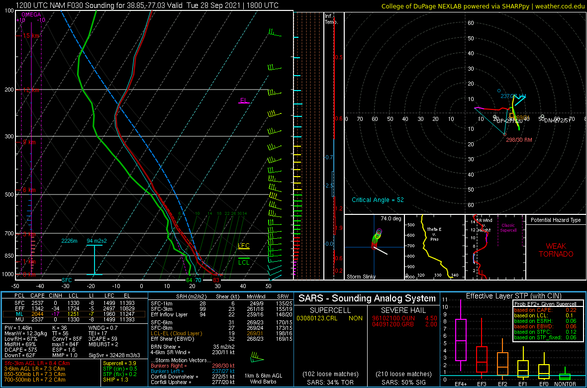
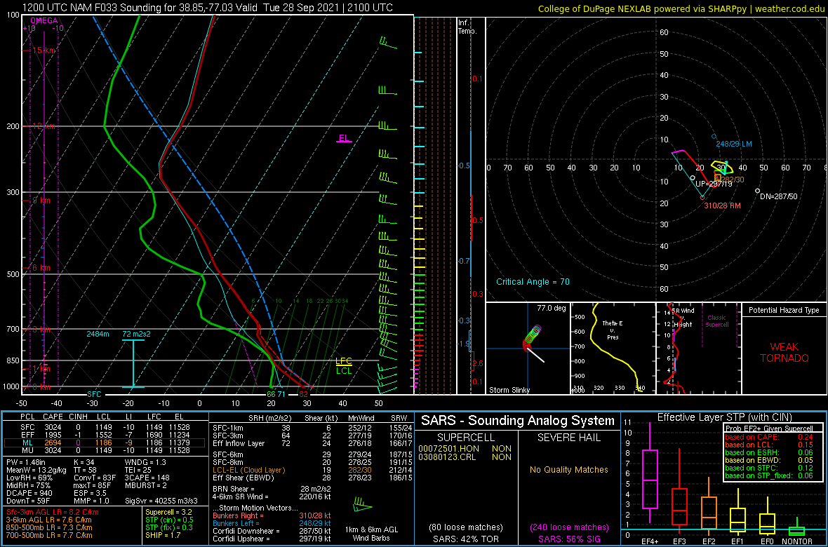
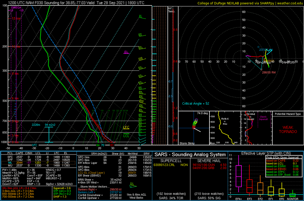
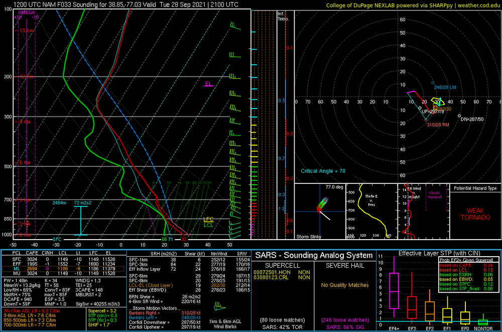
12z NAM at KDCA for both 18z and 21z TUES shows quite a large amount of SARS loose matches for severe hail... and even supercells
-
Looking at the 12z NAM soundings... I'd think 2500 SBCAPE with LI in the -7 to -9 range is a bit overdone... but hmmm ConvT is in the low 80s... should breach that in the afternoon
-
AFD was discussing 1000 CAPE with potential of over 2000