yoda
-
Posts
60,268 -
Joined
Content Type
Profiles
Blogs
Forums
American Weather
Media Demo
Store
Gallery
Everything posted by yoda
-
Its crap snow. Next Better than the Euro
-
00z gfs has snow in DC at 99 and 102 and 105 (Friday storm)
-
We fine... they lost a few inches
-
00z gfs nudged south just a tad... but big changes for the MRB to FDK crew if you believe this run
-
NEAR TERM /THROUGH MONDAY/... -- Changed Discussion -- 9:30 PM UPDATE: Latest surface analysis depicts that the cold front has pushed through the entire forecast area at this point, with cooler temps and drier air pushing in behind it. Low pressure is developing over the GA/AL border and moving in our direction tonight. In the wake of the cold front pushing through, the low pressure will begin to spread precipitation northeastward across the region starting late this evening and continuing into the early morning. Latest HRRR and NAM have continued a slight northwest shift. For this reason, updates are forthcoming to the forecast. Have decided to add eastern Loudoun County, VA into the Winter Storm Warning given this trend. QPF amounts have continued to trend upwards even into southern Baltimore, southern Harford, and Cecil counties in MD. However, uncertainty is still too high, so won`t be changing anything there for now headline wise
-
Eastern Loudoun upgraded to WSW from WWA
-
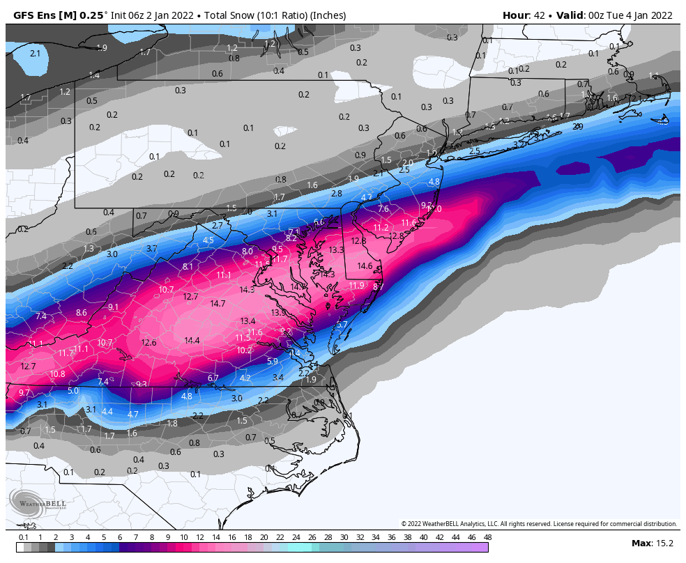
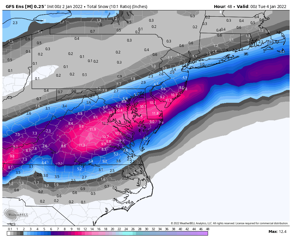
Big 18z GFS run here
-
National Weather Service Baltimore MD/Washington DC 339 PM EST Sun Jan 2 2022 .SYNOPSIS... A cold front will cross the region this evening, with low pressure then moving northeastward along the front late tonight into Monday. High pressure will return Tuesday before a weak system passes east Tuesday night. High pressure will return Wednesday before another system threatens for Thursday night and Friday. && .NEAR TERM /THROUGH MONDAY/... Latest analysis shows cold front across western Maryland and eastern West Virginia, sliding southeast across the region. To the south, low pressure is organizing over Alabama and Georgia and will be riding northeast across the Carolinas tonight and off the coast Monday. A few showers will cross the region this evening as the cold front crosses the area. Temps will fall rapidly behind the front. Quick on its heals, the low pressure will begin to spread precipitation northeastward across the region starting late this evening and continuing into the early morning. Guidance has come into better agreement and has trended significantly further northwest, so have increased snowfall totals and expanded warnings and advisories. Will be continually reviewing latest guidance this evening given still significantly discrepancies between model guidance, as well as great potential for a very sharp northwestern cut-off with some models showing a range from nothing to 6 inches within just a dozen miles or so. Great concern exists regarding potential for an intense FGEN band developing close to the metro early Monday which could drop 1-3 inch snowfall rates across the region. At this time, best odds favor locales just southeast, but potential does exist for upwards of a foot somewhere in our CWA. Nailing that location down is the hard part. Storm system looks a little slower so did extend some warnings into the mid-afternoon, with snow probably out of here by evening rush hour. There may be enough sun late in the day to warm temps back above freezing for most, which presents a re- freeze potential.
-
Sigh
-
18z RGEM nudged south slightly... but now shows a larger ribbon of 12"+ from around CHO to EZF into S MD that wasn't there at 12z
-
You know when Bob Chill and Zwyts (Deck Pic) are back posting... it's on lol
-
EPS mid month was quite tasty at h5
-
Not saying it's the same... but didn't we have a somewhat similar kind of storm in March a few years back? 50s/60s a few days or day before and I think with wet ground... ended up starting as snow and we got like 8"?
-
06z Euro looks really nice
-
Can't get it to show the NW TREND from the 00z to 06z... but there was no green on 00z lol
-
FWIW, 06z HRDPS moved NW too
-
06z GEFS mean 00z GEFS mean

-
Looks like 06z GEFS 12 hr QPF has nudged higher and moved slightly NW
-
06z GFS Kuchera 06z GFS snow depth change
-
QPF cut back slightly
-
29 and ripping fatties on 06z GFS at DCA at 30
-
URGENT - WINTER WEATHER MESSAGE National Weather Service Baltimore MD/Washington DC 428 AM EST Sun Jan 2 2022 VAZ036-508-021730- /O.NEW.KLWX.WS.W.0001.220103T0600Z-220103T1800Z/ Nelson-Central Virginia Blue Ridge- 428 AM EST Sun Jan 2 2022 ...WINTER STORM WARNING IN EFFECT FROM 1 AM TO 1 PM EST MONDAY... * WHAT...Heavy snow with snow accumulations of 4 to 6 inches. * WHERE...Nelson County, and Central Virginia Blue Ridge. * WHEN...From 1 AM to 1 PM EST Monday. * IMPACTS...Travel could be very difficult. The hazardous conditions could impact the morning commute.
-
URGENT - WINTER WEATHER MESSAGE National Weather Service Baltimore MD/Washington DC 428 AM EST Sun Jan 2 2022 VAZ025>027-029-030-037>040-050-051-501>504-507-WVZ505-506-021730- /O.NEW.KLWX.WW.Y.0001.220103T0600Z-220103T1800Z/ Augusta-Rockingham-Shenandoah-Page-Warren-Albemarle-Greene- Madison-Rappahannock-Orange-Culpeper-Northern Fauquier- Southern Fauquier-Western Highland-Eastern Highland- Northern Virginia Blue Ridge-Western Pendleton-Eastern Pendleton- 428 AM EST Sun Jan 2 2022 ...WINTER WEATHER ADVISORY IN EFFECT FROM 1 AM TO 1 PM EST MONDAY... * WHAT...Snow. Additional snow accumulations of 2 to 4 inches. * WHERE...Portions of central, northern, northwest and western Virginia and eastern West Virginia. * WHEN...From 1 AM to 1 PM EST Monday. * IMPACTS...Plan on slippery road conditions. The hazardous conditions could impact the morning commute.
-
URGENT - WINTER WEATHER MESSAGE National Weather Service Baltimore MD/Washington DC 428 AM EST Sun Jan 2 2022 DCZ001-MDZ013-014-016>018-VAZ052>057-021730- /O.NEW.KLWX.WS.A.0001.220103T0600Z-220103T1800Z/ District of Columbia-Prince Georges-Anne Arundel-Charles- St. Marys-Calvert-Prince William/Manassas/Manassas Park-Fairfax- Arlington/Falls Church/Alexandria-Stafford-Spotsylvania- King George- 428 AM EST Sun Jan 2 2022 ...WINTER STORM WATCH IN EFFECT FROM LATE TONIGHT THROUGH MONDAY AFTERNOON... * WHAT...Heavy snow possible. Total snow accumulations of 3 to 6 inches possible. * WHERE...Portions of The District of Columbia, central and southern Maryland and central and northern Virginia. * WHEN...From late tonight through Monday afternoon. * IMPACTS...Plan on slippery road conditions. The hazardous conditions could impact the morning commute.
-
Damn... from morning LWX AFD "The most likely snowfall forecast should be used with caution, with probabilities of higher amounts, towards the 90th percentile, should strongly be considered for planning purposes. Please continue to check back as we modify this forecast in the coming hours."