yoda
-
Posts
60,268 -
Joined
Content Type
Profiles
Blogs
Forums
American Weather
Media Demo
Store
Gallery
Everything posted by yoda
-
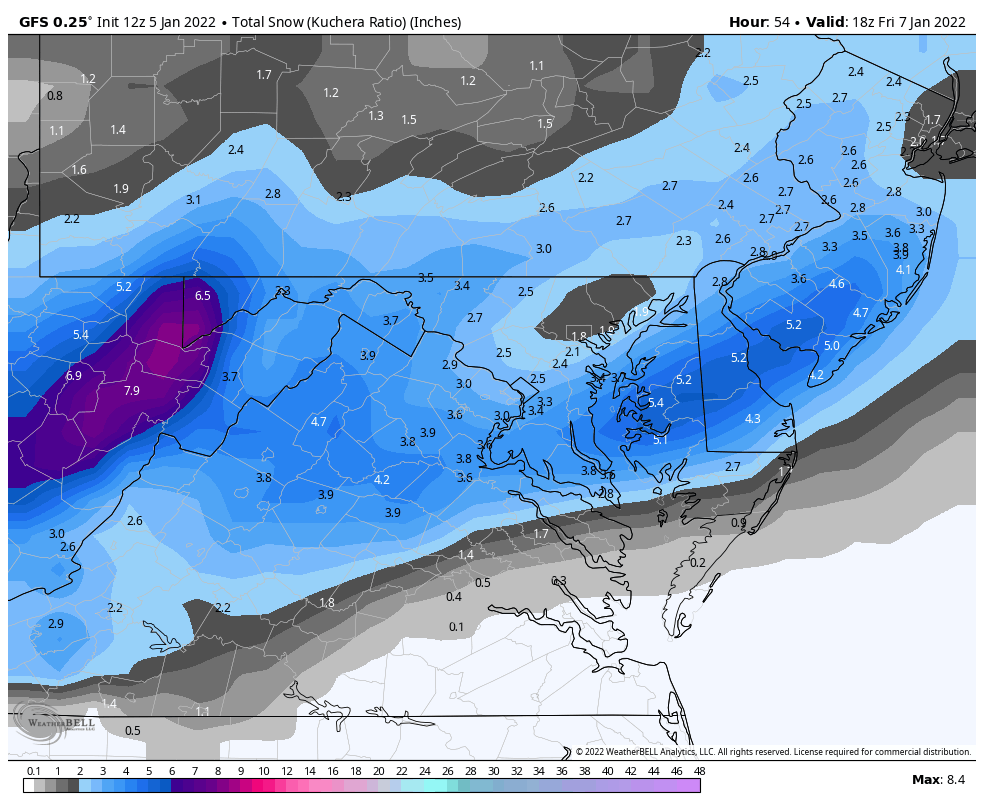
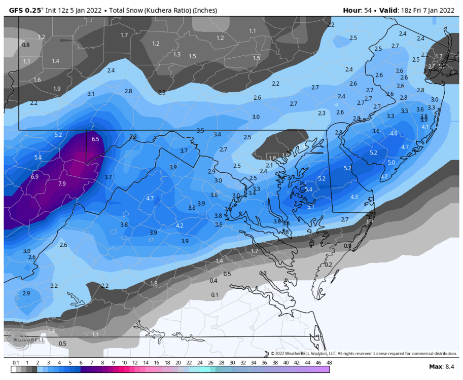
Basically 5-7 inches for everyone except extreme S MD on that map
-
I made the bad choice of looking at the 850mb temps
-
Yes please h/t @ORH_wxman
-
Bolded sounds tasty and fun URGENT - WINTER WEATHER MESSAGE National Weather Service Baltimore MD/Washington DC 233 PM EST Wed Jan 5 2022 DCZ001-MDZ005-006-008-011-013-014-016-018-503>508-VAZ052>054-502- 506-060345- /O.NEW.KLWX.WW.Y.0003.220107T0200Z-220107T1000Z/ District of Columbia-Carroll-Northern Baltimore-Cecil- Southern Baltimore-Prince Georges-Anne Arundel-Charles-Calvert- Northwest Montgomery-Central and Southeast Montgomery- Northwest Howard-Central and Southeast Howard-Northwest Harford- Southeast Harford-Prince William/Manassas/Manassas Park-Fairfax- Arlington/Falls Church/Alexandria-Southern Fauquier- Eastern Loudoun- 233 PM EST Wed Jan 5 2022 ...WINTER WEATHER ADVISORY IN EFFECT FROM 9 PM THURSDAY TO 5 AM EST FRIDAY... * WHAT...Snow. Total snow accumulations 2 to 4 inches. Isolated high amounts of around 5 inches are possible. * WHERE...The District of Columbia, portions of northern and central Maryland, and northern Virginia. * WHEN...From 9 PM Thursday to 5 AM EST Friday. * IMPACTS...Plan on slippery road conditions. The hazardous conditions could impact the Friday morning commute. * ADDITIONAL DETAILS...The heaviest snow is expected between 10 PM and 2 AM when snowfall rates of 1 inch per hour are possible.
-
Not official till I C and P all warnings and advisories in this thread lol
-
-
-
I know its unlikely, but would LWX go WSWatch for even for 3-5" considering the recent heavy snowfall in the SE zones (aka I95 corridor into EZF/S MD)? Even if LSR's are 12:1? 0.3" QPF (let's just say for DCA) would suggest near 4" (which is below the 5" WSWatch criteria)... but with powdery snow on top of wet cement snow/ice... wouldn't that create more hazards? Just a thought. I figure LWX takes that into account clearly... but wondering what others thought
-
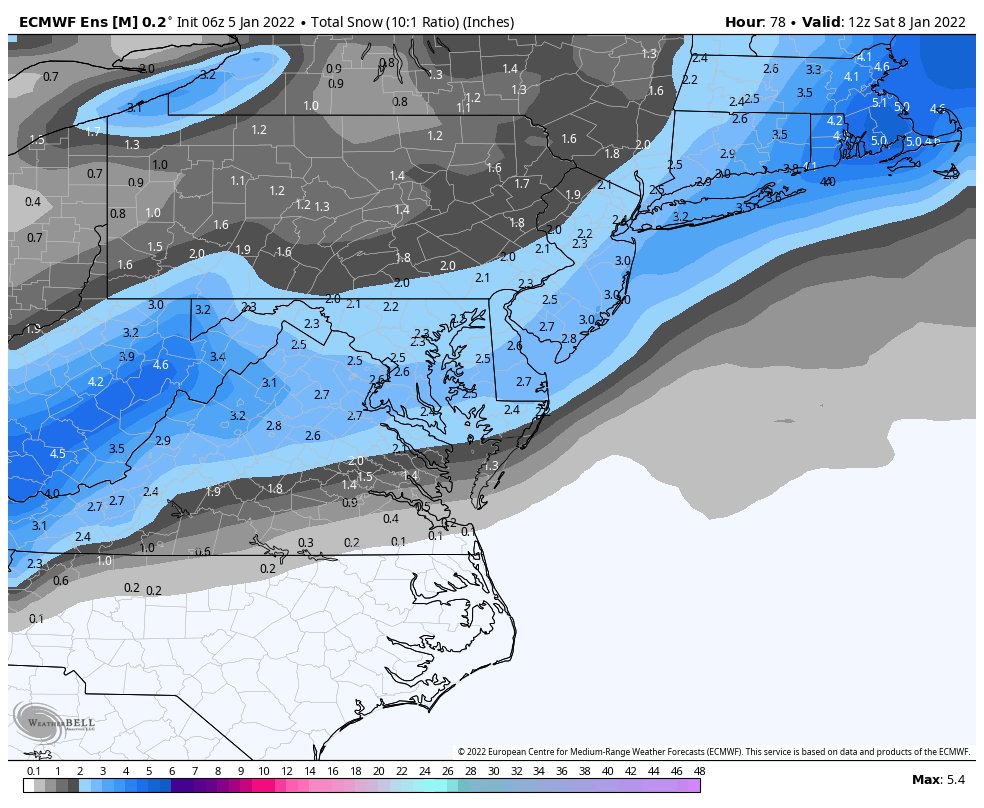
I think 06z EURO was near 0.3" near DCA?
-
Sorry @mappy
-
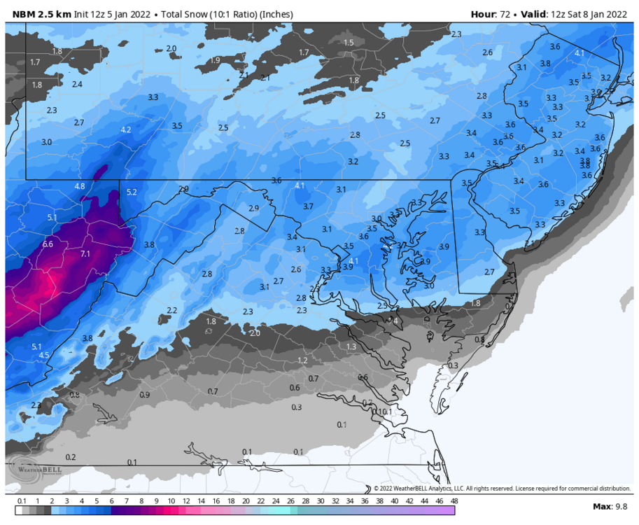
Lol NBM is National Blend of Models... so I assume that this would be an excellent resource
-
12z NBM increases an inch or so over 06z run for most of the CWA
-
12z WRF-ARW2 has some definite banding as the snow arrives
-
12z 3k NAM is 2 to 4 for most looking at Kuchera
-
Looks like 12z NAM is moving the s/w over New England north a bit, rising heights a tad through 26 Can see a slightly south movement of the QPF field and SLP placement comparing 12z 30 to 06z 24
-
Talking about SRs... wasn't there a website that showed that? Or forecasted? I remember seeing it before
-
Only if you accept being in a drought zone forever lol
-
43 of the 50 06z EPS individual members give KOKV 2"+
-
Per the latest zones... DCA is forecasted to reach highs around 30 on Tuesday. That would be the first time in a while of a subfreezing high at DCA, yes?
-
Re 6z EPS About 35 of the 50 individual members give DCA 2"+... around 13 or so give DCA warning criteria (around 5" or so)
-
Sorry had to clear space for the attachment... added now
-
6z EPS was a good increase for all

-
Super LR 06z GFS - about Day 12 on - sends us to the freezer... highs in the 20s for the rest of the run with lows single digits for most with some teens in metros... looks like some below zero nights Day 14 to Day 16 in the region as well
-
06z GFS says most of us are below freezing for highs on Monday... may stay in the 10s in the mountains and mid 20s for most on Tuesday