Chrisrotary12
-
Posts
6,163 -
Joined
-
Last visited
Content Type
Profiles
Blogs
Forums
American Weather
Media Demo
Store
Gallery
Everything posted by Chrisrotary12
-
I think this is more what I was thinking when I made my statement. And to help keep us on topic. I don't hate the ensemble look either. At least this time we're not rooting for it to stay underneath us. Much prefer wishing for a NW trend than praying for it to trend southeast.
-
Can that northern stud just scoop up all of the others ones?
-
Do people (especially those here on the board) still watch the news for weather forecasts?
-
I mean, good luck trying to figure this out.
.png.9e6aa029c8ca87241fb6067e6d30c9fd.png)
-
We're on to spring?
-
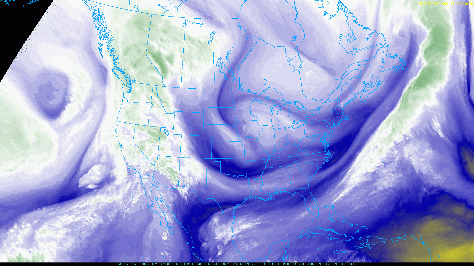
I don't know diddly about the data assimilation mechanics of the individual modeling systems, but when the system was over the eastern Pacific and really only being sampled by satellite, we had pretty good agreement. (look at 00z Tue runs for example). But as soon as the system came onshore of the west coast and presumably was sampled by the radiosonde network, the goal posts between the individual modeling systems seem to be widening. Definitely from an OP perspective and a bit from an ensemble perspective. The GEPS is way west compared to EPS and GEFS (00z suite).
-
It's impressive to me how the level of model agreement (at least in the OPs) is decreasing with time.
-
EPS definitely ticked north with the ULL.
-
Is it too early to talk about the D10 system from last nights 00z GFS?
-
Storm may be 6 days out and there are a dozen things to figure out, but it's actually on approach to the west coast now.

-
I wonder if we can go a whole winter with the primary storm track being NM -> MN -> through NE. Brick wall at the Canadian border.
-
The Canadian Op is wild for next week. Massive ocean storm spinning just offshore followed by what looks like could be biggie setting up for the following weekend.
-
Easy come. Easy go. Nice & white this morning. Probably somewhere between 1-2". Will melt by suppertime with the way it is falling off trees.
-
I just want to wake up tomorrow to snow on the ground. That'd be cool.
-
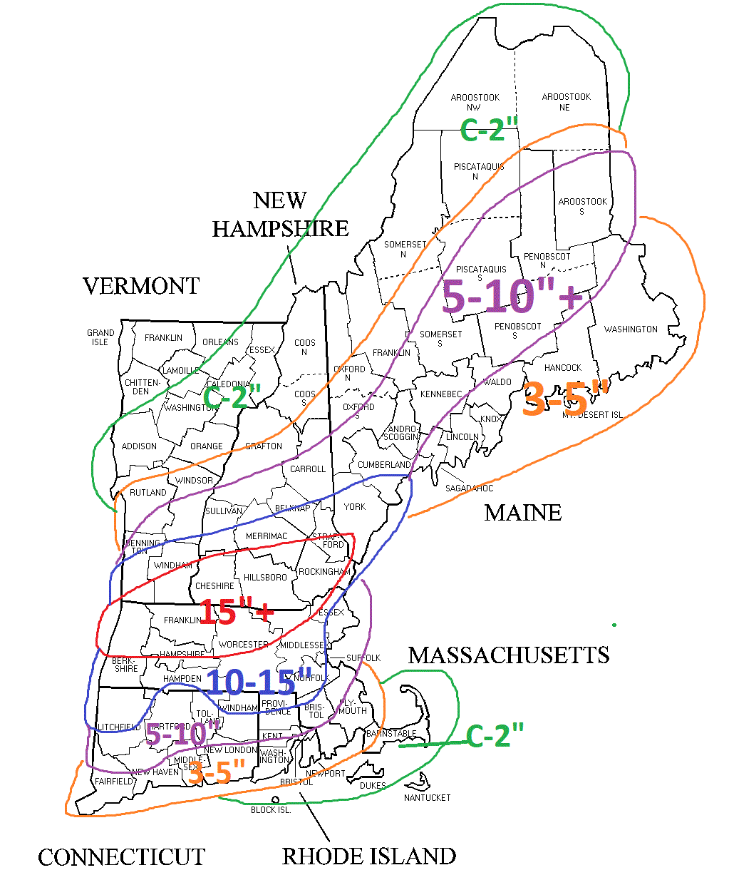
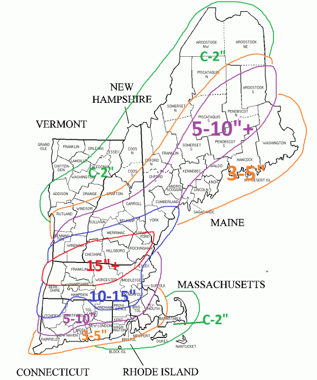
You know what would be helpful? If someone who is good at computer graphics could create a composite snowfall map from the last 10 SWFEs. Then when one shows up in the models, we would all know what we are getting....plus/minus X% based on anticipated storm characteristics. I'll gladly take the standard 6" from a SWFE right now. At least cover up the dead.
-
Some of you need to lay off the sauce this early in the morning. Yikes. Starting to think we should all be 5 ppd. Would immediately improve the readability of this place.
-
Even in winter time convection, CT is the place to be.
-
What's the definition of significant icing? Pretty quick analysis of 12z GFS & GGEM puts most locals at ~0.25" qpf of potential freezing rain.
-
Half decent model agreement for the Day 7/8 system. Definitely something to watch in between rain storms.
-
Just means prices go up.
-
It'd be sweet if that meso-low east of the main low could back it up and force it southwest just a touch.
-
Assuming I counted correctly, KASH has recorded snow for 45 straight hours.
-
Started shoveling around 630. Each time I finished a chunk of the driveway it had another 1/2-1 inch on it. Puked beautiful dendrites while I was out there.
-
My final call. One of the lower confidence forecasts I've made. High bust potential in either direction I feel. I couldn't talk myself into what the upper range might be.
-
As long as it has the same general theme as the GFS. At this point, that's all I'm looking for.