

weatherbear5
-
Posts
289 -
Joined
-
Last visited
Content Type
Profiles
Blogs
Forums
American Weather
Media Demo
Store
Gallery
Everything posted by weatherbear5
-
It ain’t lack of precip. 1.5-2.0+ inches liquid from Tappan Zee East. Some kinda sneaky warm layer
-
That’s the UKmet, correct? I have a very hard time believing there’s a lot of P-type issues at the coast with that kind of track...
-
According to the map posted in the NE forum, LI gets less than 10 inches of snow on 2.0 inches of liquid. Clearly there’s some kinda precip issues there
-
Temp profiles will be interesting... high looks to be in a good spot there
-
Active mid December with multiple event potential
weatherbear5 replied to Typhoon Tip's topic in New England
I’m technically on Long Island, so not my subforum, but still haha -
Active mid December with multiple event potential
weatherbear5 replied to Typhoon Tip's topic in New England
That, and it would limit the intrusion of warm air in the mid levels -
One thing I think we will continue to see for sure is a tightening of the gradient on the northern end of wherever the northern extent does set up. it wouldn’t surprise me if the widespread heavy snow on the far northern end more banded in nature... models might not have the resolution to pick up on that so instead of picking up on where the band will set up and putting QPF there, they end up vomiting QPF over a larger area
- 3,762 replies
-
- 1
-

-
- heavy snow
- heavy rain
- (and 3 more)
-
GFS isn’t even really north. It just consolidates into a stronger low and tucks it into the coast. The N/S differences between the 0, 6, and 12Z are very small.
-
Only out to 48 on the collaboration RGEM site, and only see the surface. The low over the NW Atlantic is closer to 50-50, so that’s an improvement. Maybe it helps lock that high in better. TBD
-
People who post on here more or less LOVE interesting weather. Don’t go to a weather forum if you don’t want to see people hope for interesting weather If you don’t like snow so much, move to Florida where it never snows. It will make you happy all winter long
-
Honestly, in that look, it looks more like a front-end dump which would be mostly snow and then changing over. Would still be good accumulations even for the coast A good move from 6z for sure. Hopefully that trend continues for the rest of the 12z suite
-
The NAM SHOULD be at least a little south of 6z, based on the 500mb setup. Haven’t looked at the surface, and I don’t until I get through the 500mb stuff
-
12z NAM 500mb through 45 hours- definitely more confluence over the NE this run, heights are noticeably lower in the NE quadrant of the country vs 6z Interestingly enough, the ridge moving onshore to the west coast is coming in significantly stronger as well. I wonder if this will help the shortwave to dig a bit more. With any luck the 500mb feature would end up passing south of LI we shall see
-
12z NAM 500mb. Through 21z the shortwave is in virtually the same position as the 6z, maybe a hair weaker. In addition, heights over the NE seem to be more compressed, a sign which could mean confluence is stronger
- 3,762 replies
-
- 1
-
-
- heavy snow
- heavy rain
- (and 3 more)
-
Yup. Coastal people should not celebrate a more amped wave out west. We’ve pretty much run out of runway with the confluence getting ready to exit stage right. Any delay in that S/W and we more than likely turn to rain at the coast for at least a time. Inland folks do want the stronger, slower s/w I guess though
-
In other news, the wave we need to monitor out west will be well onshore by 12z today, so we should have very, very good sampling for the 12z runs
- 3,762 replies
-
- 1
-
-
- heavy snow
- heavy rain
- (and 3 more)
-
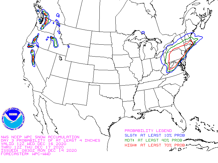
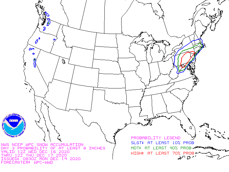
WPC snowfall probs for 4 and 8 inches of snow if you’re going to use their forecast to play “riddle me this” and support your idea that there won’t be 6 inches of snow, at least use their full forecast and don’t cherry pick what you think makes you look right it could still bust in NYC, but not as of what they’re forecasting now
- 3,762 replies
-
- 1
-
-
- heavy snow
- heavy rain
- (and 3 more)
-
The 6z run is what I was alluding to. Too amped isn’t a good thing At this point we’d rather a flatter wave that moves faster, even if it means it gets squashed somewhat. A slower, more amplified wave allows time for the confluence to slacken thus allowing it to run further north which is a warmer solution
-
With the NAM, I reviewed the Skew-T's for some sneaky warm-layers. We need to keep an eye on the 725-775 MB levels near the coast, as that is where it will go above freezing, if at all. I pulled a point over LI for reference, and while the 18z briefly got that layer above freezing, the 00z never did, so it was definitively colder with no (or very, very minimal) sleet on Central LI. I saw the RGEM is a monster hit as well. Models always underdo CAD at the surface... though they also tend to underdo mid-level warming, so that's definitely something to keep a close eye on
-
Careful what you wish for. Trough axis is definitely further west than 18z so far
- 3,762 replies
-
- 1
-

-
- heavy snow
- heavy rain
- (and 3 more)
