msuwx
-
Posts
673 -
Joined
-
Last visited
Content Type
Profiles
Blogs
Forums
American Weather
Media Demo
Store
Gallery
Everything posted by msuwx
-
Yep. Day 6-7
-
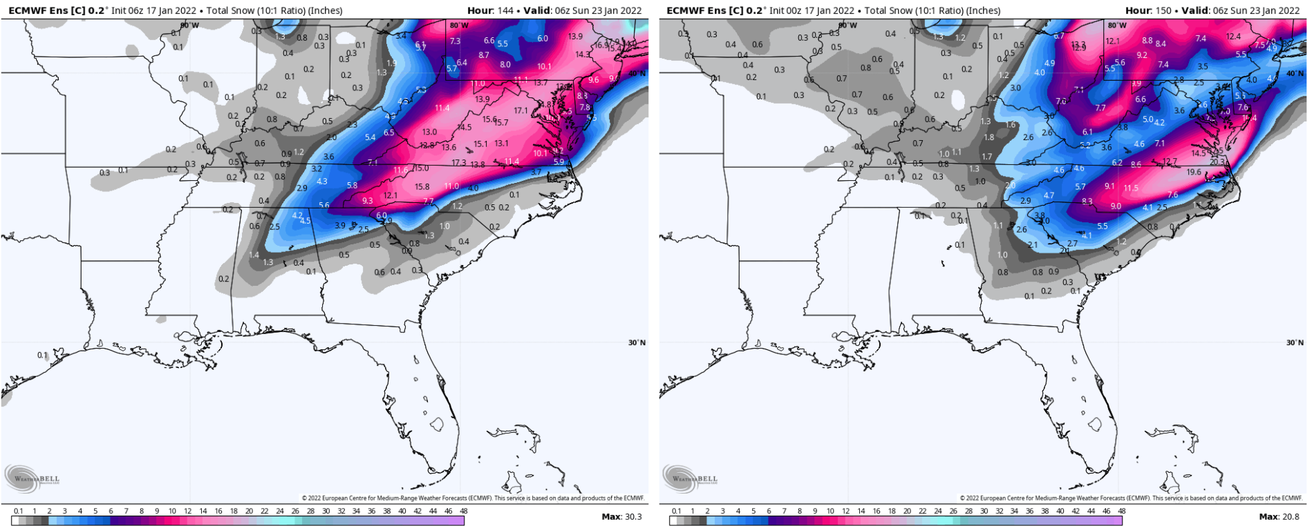
This one is pretty straightforward. It is simply a matter of timing the phase. Some modeling has been phasing too late to really bring any appreciable precipitation. A couple of runs have phases at the perfect time to bring a significant snowstorm. All about the 500mb vorts.
-
While the Euro may continue to be scoring higher when looking at the scoring of upper air height anomaly verifications and what not, there is no doubt that the GFS has sniffed out and had more accurate ideas with individual storms in the day 5-10 range compared to the Euro around here. And that dates back to hurricane season too.
-

January 20-22 “bring the mojo” winter storm threat
msuwx replied to lilj4425's topic in Southeastern States
I missed this yesterday..... Yes! I think they will! haha -
January 20-22 “bring the mojo” winter storm threat
msuwx replied to lilj4425's topic in Southeastern States
A westward expansion of the WSW is imminent. -
January 20-22 “bring the mojo” winter storm threat
msuwx replied to lilj4425's topic in Southeastern States
If the models were always right, there would be little fun in meteorology (at least the forecasting aspect of it). We could all just look at what our weather apps printed out and go about our day. The learning, the chasing, the gut instincts, and the insight from years of studying this awesome, dynamic, always-changing atmosphere....that's what makes forecasting fun. Forecasting winter weather is hands-down the most difficult and complex forecasting I do. But those are the same reasons it is my favorite type of forecasting. I welcome the challenge and always try to come away a little wiser from each system. Enjoy the ride. Learn. Be fascinated by the atmosphere. ....We now return you to your regularly-scheduled programming... -
January 20-22 “bring the mojo” winter storm threat
msuwx replied to lilj4425's topic in Southeastern States
I'm afraid it's now a trend over the last couple of cycles. 6z RGEM, 6z NAM, and 12z NAM all went in that direction. -
January 20-22 “bring the mojo” winter storm threat
msuwx replied to lilj4425's topic in Southeastern States
-
January 20-22 “bring the mojo” winter storm threat
msuwx replied to lilj4425's topic in Southeastern States
Yeah northern branch might be well out ahead this time on the 12z NAM. Let's see where it goes. -
January 20-22 “bring the mojo” winter storm threat
msuwx replied to lilj4425's topic in Southeastern States
I haven't put out numbers yet, but here is what I drew up for a probability of 2" of snow as of early this morning.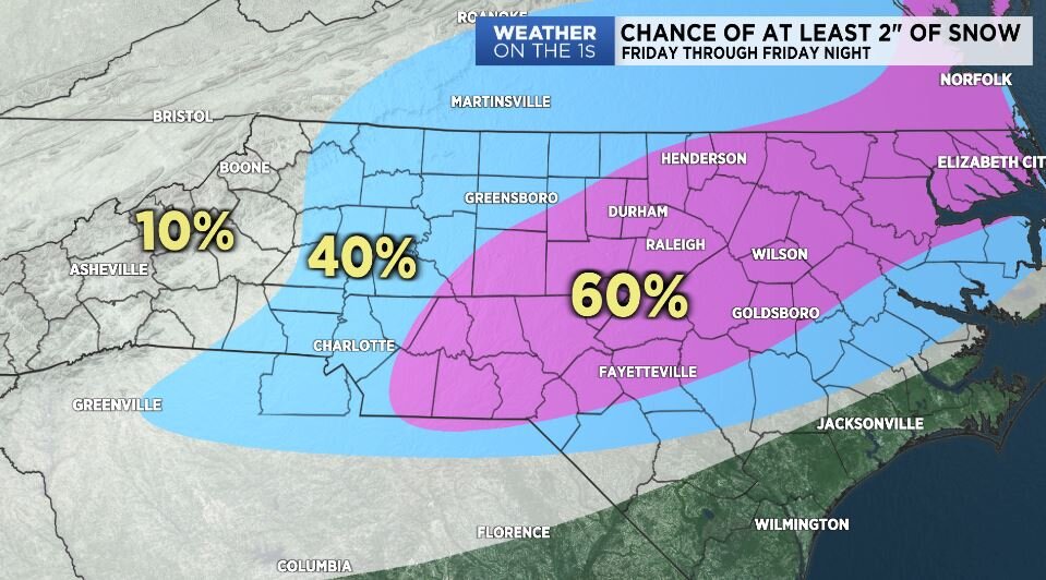
-
January 20-22 “bring the mojo” winter storm threat
msuwx replied to lilj4425's topic in Southeastern States
The Charlotte metro and surrounding area is an incredibly difficult call as it all hinges on a very subtle (in the overall scheme of the atmosphere) NW expansion of the back edge of the snow shield. I mean these are very small differences when looking at the atmosphere as a whole, but the result has been very wild swings in possible snow totals in that part of the region, even just over the course of the 0z and 6z runs. 6z vs. 0z Euro:.thumb.png.82193007c48d05120838625b8d61a769.png)
-
January 20-22 “bring the mojo” winter storm threat
msuwx replied to lilj4425's topic in Southeastern States
Yeah it was interesting. This is in its traditional wheelhouse, so it might be worth noting. -
January 20-22 “bring the mojo” winter storm threat
msuwx replied to lilj4425's topic in Southeastern States
Indeed: -
January 20-22 “bring the mojo” winter storm threat
msuwx replied to lilj4425's topic in Southeastern States
I wouldn't sound too many alarms just yet, but the ice signal looks a little stronger on this one from afar to me. -
January 20-22 “bring the mojo” winter storm threat
msuwx replied to lilj4425's topic in Southeastern States
That is a stronger ice signal on the NBM than I ever remember seeing leading up to our last storm. -
January 20-22 “bring the mojo” winter storm threat
msuwx replied to lilj4425's topic in Southeastern States
I am not seeing a big difference between the 0z EPS and the 6z EPS as far as Carolina interests are concerned. Nothing that isn't within the 'noise' range. It's definitely a little colder, but the resulting snow is largely unchanged.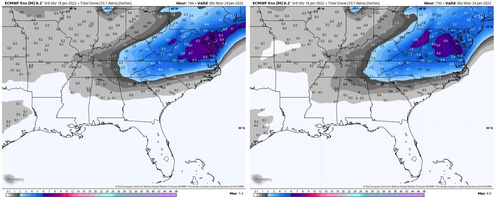
-
January 20-22 “bring the mojo” winter storm threat
msuwx replied to lilj4425's topic in Southeastern States
When you ae dealing with stream interaction/ phasing, the UKMET is usually one of the best. We shall see. -
January 20-22 “bring the mojo” winter storm threat
msuwx replied to lilj4425's topic in Southeastern States
Nah the warm nose aloft was pretty well modeled. It was always a fine line between sleet and ZR. Asheville transition to sleet by midday. The reason sleet prevailed in many spots (instead of ZR) is because of the very impressive surface cold layer….in terms of actual temps and depth up to at least 925mb. -
January 20-22 “bring the mojo” winter storm threat
msuwx replied to lilj4425's topic in Southeastern States
Yeah, the control did jump NW. But remember that's really just one member of the ensemble package. Any changes in the ensemble mean from 0z to 6z were quite negligible..thumb.png.9ed8aeade94ac061aa1bdc1a260d1561.png)
-
January 20-22 “bring the mojo” winter storm threat
msuwx replied to lilj4425's topic in Southeastern States
6z vs. 0z control for anyone wondering.
-
It’s weird to me how this board can be lit up like a Christmas tree analyzing the Day 8 NAVGEM, but now that a major storm is about to hit many, many people in the region, the post frequency tails off. Is it because the storm isn’t producing pure snow for many? Eastern NC getting the short end of the stick? To me, this is pretty easily the most significant winter storm, per capita, in a few years.
-
That is a big reason why you never achieve the maximum freezing rain depictions on modeling in reality. Much is lost to runoff and other factors. Freezing rain just simply cannot physically accrue at 100% of the QPF rate unless it is extremely light in general and temperatures are very cold.
-
Ha ha ha. I put some thoughts earlier today on Twitter and Facebook. My daughter had surgery today, so hopefully I will be more active tomorrow. good trends!
-
I’m such a nerd with CADs. I find them fascinating, and this is a textbook example being modeled right now. It’s fun to watch the atmospheric physics in motion. As things are currently depicted, it’s a case study setup for a western and central ( some portions) NC, western SC, and even northeast GA CAD winter storm For those that are unhappy with the trends, let the timing or intensity of the Northeast high get out of whack….then you get wailing and gnashing of teeth as many wind up with a 42° driving rainstorm.
-
No….70° + in winter is the worst.


.png.d144092c116918385d343abeecaec46e.png)

.png.922977f04f5a91df9b7e75ac13647a26.png)