Dunkman
-
Posts
2,099 -
Joined
-
Last visited
Content Type
Profiles
Blogs
Forums
American Weather
Media Demo
Store
Gallery
Everything posted by Dunkman
-
I've heard a lot of people (mets) say that over the years. And then we mix.
-
I'm not going to pretend to have a better feel for this than RAH does but I did find it kind of interesting that they opened saying it looked like a significant winter storm and then proceeded to forecast conditions that are very much not significant for the region.
-
If we were ever gonna stop living and dying with every model run it would have happened by now.
-
Yeah I need to get new sleds for my kids tomorrow so if she (and the other local mets) could be conservative until tomorrow evening that would be perfect.
-
There isn't even an eyewall left at this point so I'd say definitely not.
-
Upper level wind shear sending dry air into the southern half of the system.
-
We spent days thinking this wouldn't be the usual east coast half a cane on approach and, umm, oops?
-
What do you think about the coastline perhaps providing some friction to help Florence tighten up a bit? Seems like we've seen that happen in the past.
-
You may see one at 11 if this is all recon finds.
-
On the last recon pass they measured category 2 surface winds 50 miles north from the center. I think pretty much every model has the storm getting that close or closer to Jacksonville at some point.
-
The surge is going to be held in place by relentless onshore winds for days it seems in certain places.
-
I mean right now you have 111mph flight level winds 110 miles north of the center. And the hurricane force wind radii seem to only be expanding. I certainly think they're trying to be proactive but I wouldn't call it ridiculous with a storm this size. Strong rain bands can absolutely mix those winds down to the surface at times.
-
I didn't expect this storm to get the classic east coast comma shape with weaker/drier west and south sides but it certainly looks to be taking on that appearance. Maybe it's just temporary but it could be tough to maintain cat 4 with that structure.
-
Well highest SFMR on the first pass was 101 kts. FL was a little better at 126 but Florence may have trouble maintaining cat 4 now with the expanded wind field.
-
I know it's a fairly new product but that's still really freaking ominous.
-
12z UK went well north of Wilmington.
-
It doesn't look like any models really want to strengthen the storm much from here on in which would certainly be a blessing. That said, satellite is looking better all the time.
-
GFS and getting a clue 3 days late. Name a more iconic duo.
-
950mb/130mph at 11am. I'm a little surprised they didn't bump the winds back up to 140 given what recon found but it hardly matters.
-
Looking at the Euro ensemble tracks from 00z it's almost as if they smoothed out the tracks that many of the other models are seeing. Like instead of going NW until off of ILM and then due west the EPS just goes WNW the entire time and ends up in more or less the same spot after 120-144h.
-
Yeah it could have been COAMPS instead of HMON. Those are the models they used last year. For some reason I thought they had tweaked it this year but I've been trying to find where I saw it and can't so there's a good chance I just imagined it.
-
Just to add, I believe for 2018 the TVCN is equally weighted GFS, ECMWF, UKMET, HWRF and HMON. (I actually can't find where I saw that but I think that's what I remember reading)
-
I posted this in the main thread as well but recon just found 165 mph flight level winds in the NE quad. Was definitely hoping the ewrc had dropped the winds more than this.
-
I don't trust the NAM, or really anything outside of the operational EC, UK and GFS, to have any chance to resolve this complicated steering pattern. Even if the NAM does stumble into an ultimately correct solution it's probably more of a broken clock being right twice a day scenario.
-
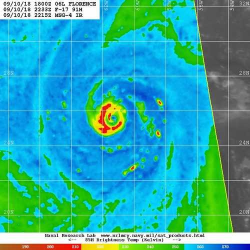
I posted this in the main thread as well but from the mw pass a couple hours ago it does look like some definitely core reorganization going on. I don't know if I'd call it a full eyewall replacement but there's a secondary maxima on at least half of the storm.