Dunkman
-
Posts
2,099 -
Joined
-
Last visited
Content Type
Profiles
Blogs
Forums
American Weather
Media Demo
Store
Gallery
Everything posted by Dunkman
-
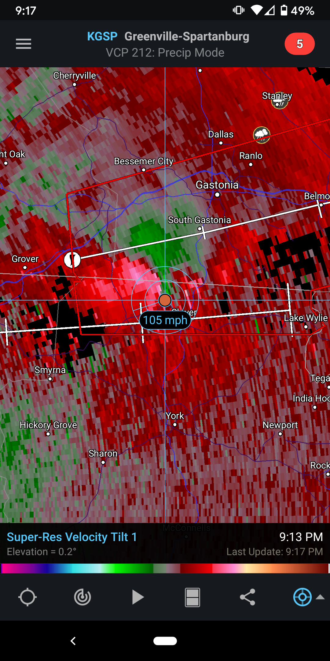
Well got a new scan from GSP so it seems the radar is ok. Storm heading into Charlotte is struggling.
-
They both have pretty good rotation right now.

-
I'm surprised the 1st storm isn't warned. There's good rotation on the higher beam tilts and they're still only a couple thousand feet up.
-
Yeah it's rough beam is at 13k feet.
-
Is 20% EF2+ kinda high for a thunderstorm watch?
-
I really hope that's hail the cc out of CLX is picking up.
-
Kinda odd here in central NC. Went from nothing to 10% hatched and back to nothing in less than a day. I certainly don't mind, hope it's a quieter day for everyone in the south.
-
Yeah I'd be a little surprised if we didn't end up with a 15% area at some point given how large the 10% is right now.
-
Whatever that is in eastern AL is really close to the KEOX radar site and they haven't updated in over 20 minutes. edit: That's not totally accurate, I just got a 9 minute old L3 image on GR3, but it's certainly coming out slow.
-
You're in a hatched 10% tornado prob. Wouldn't put all my stock in a run of the NAM.
-
Good tornado shield there AJF. Whoever is in charge of drawing the polygons at MHX needs some assistance.
-
They did a great job of getting that warning up ahead of time in Georgia.
-
Of course the polygon is pointed right at Tuscaloosa.
-
At GSO they received 2.0" with 0.26" QPF which ended up being right in line with the Kuchera estimate of 7-8:1 for the area in the HRRR.
-
Still some light snow falling here in the Triad but I'd guess accumulations are over. Measured 1.5" on the back deck which is certainly more than I expected this morning. Nice to have something to track and see some snow fall.
-
Officially 0.7" at GSO as of 4:24. Glad to have the streak gone!
-
So is it really actually going to snow in southern Wake this time? Are we sure? Oh and nice SN here in High Point, sticking to the deck and some in the grass.
-
Is that the coastal kicking precip all the way back to GSO and CLT on the HRRR or is it from the first batch? Sorry in the middle of something and can't look for myself.
-
I just can't believe that it's a lack of moisture that's going to do us in. What a slap in the face after suffering through the wettest start of the year ever.
-
NAM continues to be drier W and SW of Raleigh with every run. If you're not in the NE quadrant of NC or the mountains anything that sticks to the ground should be considered a victory.
-
Interestingly the UK has the jackpot set up in the Kinston area much like the GFS did.
-
Magnificent March! It's the new Fab Feb!
-
If anything there was more snow on the 3k NAM at 00z than at 18z. That's reassuring for me and makes me think it's just the 12k coming back to earth rather than the start of some dramatic warming or drying up in the models.
-
The 3k NAM is actually drier west of Raleigh but wetter in Wake and to the E and NE.
-
You know if it ends up too warm and we get a lot of white rain I can live with that. It's what you'd expect from this pattern. If the precip fizzles out after every storm for months has over performed that's going to be really annoying.