

Dunkman
-
Posts
2,099 -
Joined
-
Last visited
Content Type
Profiles
Blogs
Forums
American Weather
Media Demo
Store
Gallery
Everything posted by Dunkman
-
Anyone have a link to the Cancun radar that’s not the crappy accuweather (or equivalent) version? Thanks.
-
...FLASH FLOOD EMERGENCY FOR CITIES OF CANTON AND CLYDE AND PIGEON RIVER VALLEY TO LAKE WATERVILLE... The National Weather Service in Greenville-Spartanburg has issued a * Flash Flood Warning for... Central Haywood County in western North Carolina... * Until 215 AM EDT. * At 830 PM EDT, Significant rainfall totaling 4-7 inches has been observed across Haywood County, especially in the Pigeon River headwaters south of Canton. This is producing a significant and life-threatening flood wave moving down the Pigeon River through Canton, Clyde, and into Lake Waterville. Haywood County Emergency Management is requesting residents near the Pigeon River, including in the cities of Canton and Clyde, to evacuate to higher ground immediately. Evacuees are being asked to shelter at Tuscola High School. This is a FLASH FLOOD EMERGENCY for Cities of Canton and Clyde and Pigeon River Valley to Lake Waterville. This is a PARTICULARLY DANGEROUS SITUATION. SEEK HIGHER GROUND NOW!
- 310 replies
-
- 1
-

-
- late freeze
- warm
- (and 3 more)
-
I didn’t see it posted but there’s a high risk from the WPC for today ...THERE IS A HIGH RISK OF EXCESSIVE RAINFALL IN AND NEAR WESTERN NORTH CAROLINA... ...East/Southern and Central Appalachians... For the Southern Appalachians, Fred is expected to track very near to west of the area, initially bringing upslope flow of ~40 kts and ML CAPE up to 2000 J/kg into the region. Just to the west, Fred's comma head rain pattern is expected to lead to heavy rainfall west of the chain, which some feeder bands in its wake possibly impacting western slopes as well. While model guidance showed disperson, it did not where it mattered most in the western Carolinas. The border of Transylvania/Jackson County NC was hit with heavy rainfall Monday morning, with 4-9" reported. This is also where the guidance projects another 7"+ of rainfall on Tuesday and Tuesday night. With an additional 10" possible locally, and the 00z HREF indicating a 90% chance of exceeding the 100 year recurrence interval, coordinated with the GSP/Greer SC forecast office to issue a High Risk area covering from the vicinity of Asheville NC southwestward to near the SC/NC/GA border junction. This degree of rainfall could lead to landslides/slope failures. The risk of land slips as well as scattered to numerous flash flood events extends across the Moderate Risk area encompassing terrain of northeast GA, northwest SC, and the remainder of western NC. A broad area of 4-8" is expected. A broader Slight Risk encompasses where rain bands could set up across the FL Big Bend early and SC during the morning/afternoon as well as areas which have received 200-400% of their two week average rainfall near the Fall Line in VA and MD, and includes the D.C. area. Impacts across PA and NY should be mitigated by below average rainfall over the past couple of weeks.
- 310 replies
-
- 3
-

-
-
- late freeze
- warm
- (and 3 more)
-
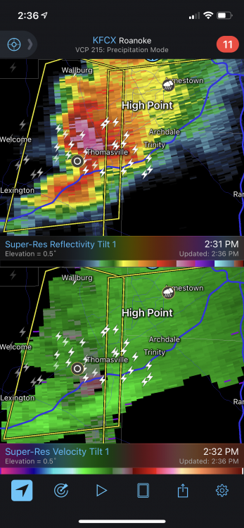
Looks like a pretty stout hail core and some rotation heading towards jburns.
-
I’m not an expert but when there’s a severe thunderstorm warning from Lenoir to Bluefield it might be time for a watch.
-
38 and 0.26" so far. 0 days since last 30 degree rain.
-
Playing the is it pollen or Covid game wasn't super fun. Hopefully my pandemic anxiety is a little better by now.
-
At least we’re going to have a mix of temperatures for our rain coming up instead of just 30s. Should be some 40 degree rain, some 50 degree rain and maybe even some 60 degree rain!
-
Hey it’s up to 41 now! Heat wave!
-
Oh yeah Raleigh gets 60 degrees and a severe thunderstorm with the QLCS but just more 30s and rain for me
-
Yeah that’s good let’s get that base up out west for my spring break ski trip.
-
It’s not out on Pivotal yet. Maybe it is on a paid site? It’s been awhile since the weather tempted me to subscribe somewhere.
-
You can’t really expect a storm with that much cold in our climate this late in the season. It really can only happen in places like the frozen tundra of San Antonio.
-
Same here. It was 12” but still...
-
That sounds good to me 3” would like quadruple my winter total
-

February 18-19 MAJOR Ice Storm Threat
Dunkman replied to NorthHillsWx's topic in Southeastern States
RAH downgraded everyone except the VA border counties to an advisory. -
February 18-19 MAJOR Ice Storm Threat
Dunkman replied to NorthHillsWx's topic in Southeastern States
I don’t know how things are everywhere but here in west central Guilford it’s melting at the point that there will be very little left by sunset. That would almost certainly make the overnight icing inconsequential. -
I mean the GEFS does have a CAD signal...
-
February 18-19 MAJOR Ice Storm Threat
Dunkman replied to NorthHillsWx's topic in Southeastern States
The melting has already started here. I’ll be surprised if there’s anything left by late this afternoon. -
February 18-19 MAJOR Ice Storm Threat
Dunkman replied to NorthHillsWx's topic in Southeastern States
Unfortunately this heavier band is all ZR so far in N High Point. I was really hoping for some sleet. -
February 18-19 MAJOR Ice Storm Threat
Dunkman replied to NorthHillsWx's topic in Southeastern States
It's important to note that this isn't an in situ event. It doesn't really matter whether clouds roll in at the right (or wrong) time to lock in warmth or let it escape. This will ultimately be controlled by air that the high pressure funnels into the region. Considering my winds are out of the SE right now I'm not really sure what impacts the current dewpoints are going to ultimately have. -
February 18-19 MAJOR Ice Storm Threat
Dunkman replied to NorthHillsWx's topic in Southeastern States
All of the above. But I wouldn’t rule out warning criteria ice either. It looks like I may be living in front of the fireplace for a few days. -
February 18-19 MAJOR Ice Storm Threat
Dunkman replied to NorthHillsWx's topic in Southeastern States
It tries to. I still have real questions about accrual if it’s gonna be 50 degrees at 850mb. We’ve had numerous potential ZR events bust over the years due to heavy rates and stout warm noses. -
February 18-19 MAJOR Ice Storm Threat
Dunkman replied to NorthHillsWx's topic in Southeastern States
RAH is somewhat more aggressive with the totals into NC. -
Yeah the ICON shows ZR and sleet as rain. I’d imagine those bright returns near the snow line in VA are sleet and all the rest is ZR.


