southmdwatcher
-
Posts
987 -
Joined
-
Last visited
Content Type
Profiles
Blogs
Forums
American Weather
Media Demo
Store
Gallery
Everything posted by southmdwatcher
-
BWI: 11.4 DCA: 10.2 IAD: 11.9 RIC: 13.0 Tiebreaker LYH: 16.5
-
Measured 0.13" from the early morning shower.
-
Without a dam failure, that reading is 5 feet above the previous record crest.
-
The pictures of the I40 washout seemed to hit social media prior to the news of the Waterville dam failure
-
With the 500mb upper low seemingly stationary over western KY and TN, wouldn't that force the track of Helene more than a little bit east of Tallahassee and Atlanta?? Thought this upper low was supposed to be cut off over Arkansas or Oklahoma to allow the western paths.
-
Tropical Storm Debby: Mid-Atlantic Impacts
southmdwatcher replied to WxWatcher007's topic in Mid Atlantic
Oh so the western folks might FINALLY get a 2 inch plus rain event. Meanwhile, the eastern folks get a tornado outbreak....or what would seem that way around here.....hope we smash the Ivan event in 2004. -
Oh my, Debby is gonna get offshore way earlier than was expected.
-
Dang, how long have you all lived here??? This region is super humid and hot during the Summer. We have all these rivers and the Chesapeake Bay. If you live up in the highlands or plateau and never lived in the lowlands then no disrespect towards you. We are close enough to eastern Canada, to have a few backdoor cold fronts each Summer that make it less humid and cooler....but some years we stay hot and humid all Summer.
-
Debby is doing a center relocation or fujiwara for the past 3 or 4 hours.....Tampa radar has had the center moving eastward for 3 hours now. That has to impact the models coming up tonight, the track and so forth.
-
There are some healthy circulations with CC drops in the band approaching Tampa area.
-
Radar is fizzling out, once again.
-
Flood Watch again for DC Metro...edit DC/FFX/PG and south and eastward.
-
Reagan National is supposedly at 100.9F at 2:20 pm as per GREarth.
-
These are some rather swift developing severe storms. Wow.
- 1,696 replies
-
- 1
-

-
- severe
- thunderstorms
- (and 5 more)
-
22/15/8
-
That line of strong to severe storms crossing the crest of the Appalachians, in West Virginia is not immediately followed up by any storms as of this moment. Tomorrow could be quite interesting in this region.
-
Storm Prediction Center May 26, 2024 2000 UTC Day 1 Convective Outlook (noaa.gov) Day 1 Convective Outlook NWS Storm Prediction Center Norman OK 0320 PM CDT Sun May 26 2024 Valid 262000Z - 271200Z ...THERE IS A MODERATE RISK OF SEVERE THUNDERSTORMS ACROSS SOUTH-CENTRAL AND SOUTHEAST MISSOURI...FAR NORTHEAST ARKANSAS...SOUTHERN ILLINOIS...FAR SOUTHWEST INDIANA...WESTERN KENTUCKY...AND NORTHWEST TENNESSEE.... ...SUMMARY... Severe storms are expected from the Ozarks this afternoon and evening to the Ohio and Tennessee Valley tonight. Tornadoes, some strong to intense, and large to very large hail are the primary threats this afternoon and evening with an evolving overnight severe wind/embedded tornado threat tonight. Primary focus of this outlook update was a moderate risk upgrade from south-central Missouri into western Kentucky and northwest Tennessee. An EML has advected across this region in the wake of morning convection which has permitted strong heating and destabilization. The outflow boundary and the destabilized region north of this boundary provide a vorticity rich low-level airmass favorable for tornadoes. Supercells are already starting to develop in the hot and unstable airmass across southwest Missouri and will move toward this vorticity rich airmass this evening. Additionally, a strengthening low-level jet is expected across this area tonight which will elongate low-level hodographs. Most members of the 18Z and 19Z WoFS show several intense, long track supercells through this region later this evening with increased 0-2km UH probabilities, giving more supporting evidence for the rapidly evolving tornado threat. Given the aforementioned factors, several strong to intense tornadoes are possible this evening. See MCD #980 for additional information about the evolving threat in this region. Eventually, these supercells will likely congeal into an MCS which amid extreme instability, strong shear, and steep lapse rates, will likely have a significant wind threat into the late evening and early overnight hours. In addition, added a small marginal risk across southwest South Dakota and northern North Dakota where a few stronger storms have developed amid weak instability and moderate shear. See MCD 982 for additional information about this threat. ..Bentley.. 05/26/2024 .PREV DISCUSSION... /ISSUED 1140 AM CDT Sun May 26 2024/ ...Ozarks/Arklatex to Ohio/Tennessee Valleys and south-central Appalachians... Ongoing/long-lived bowing complex, with a history of measured severe gusts and wind damage, continues to move east across central KY/northern TN at 16z. The downstream environment continues to destabilize as diurnal heating of upper 60s/near 70 def F dewpoints continues, and this complex is expected to continue moving east through this afternoon while maintaining a risk for damaging gusts and embedded QLCS circulations. In the wake of this convective system, a pronounced theta-e gradient has become established from northern TN westward, becoming more diffuse over southern MO, where strong heating is occurring. Severe thunderstorms are forecast to redevelop this afternoon across southern MO within a strongly sheared environment characterized by 50 kts of westerly shear, and strong MLCAPE. Supercell structures should be the dominant convective mode for several hours, with a risk for all severe hazards including very large hail and strong tornadoes. The convective system may congeal with time into more of a linear structure, with a risk for all hazards continuing into the overnight hours within an amply-sheared and moderately unstable environment. The Enhanced Risk has been expanded farther south over portions of northern MS/AL/far northwest GA based on 12z HREF calibrated guidance.
-
Don't know at all if this will impact our chances tomorrow, but SPC just upgraded western KY/TN into Missouri and Arkansas to Moderate for tornadoes, and the enhanced(10 percent hatched area) VERY significantly increased in areal coverage into northern AL/MS and all of KY/TN into far southwest VA.
-
Well lets end up with 10 percent hatched, 30 and 30
-
Needs to be a 330am alarm.....Sunrise/twilight comes in from the east too quickly if one only ventures out at 430am
-
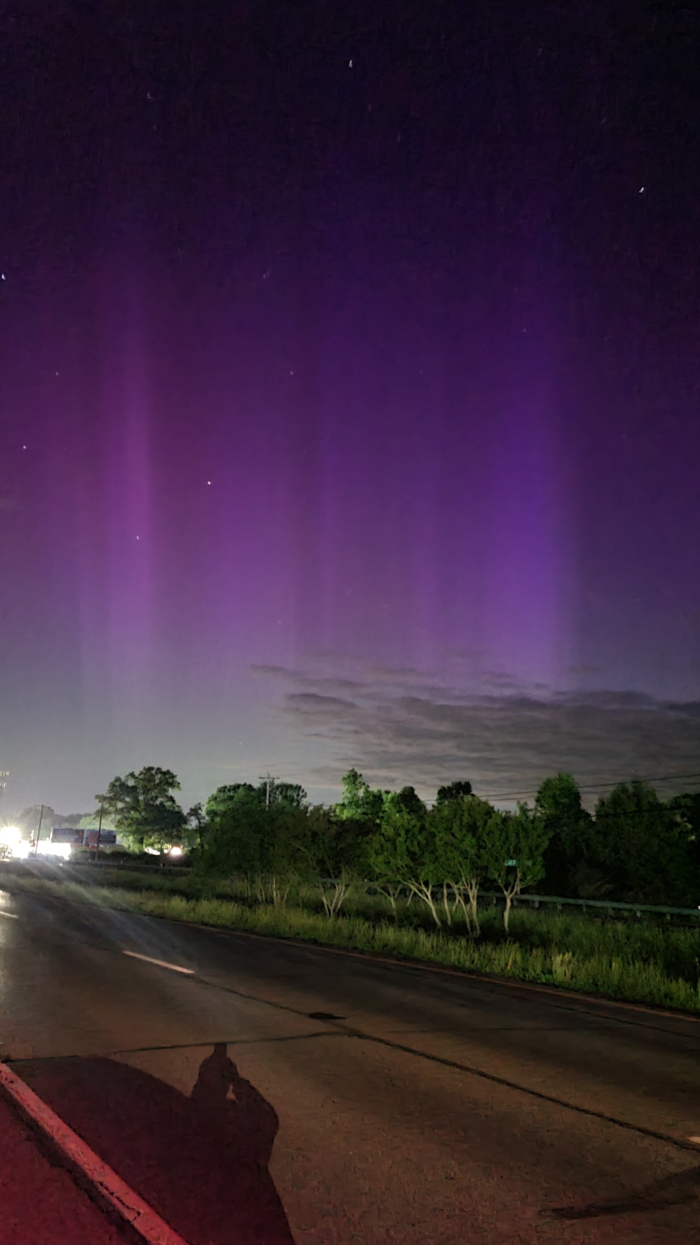
Drove to central St. Mary's county. What a nice display. Sheets and pillars visible to the naked eye and the night shot on camera got the vivid colors.

-
This is already at a level 4 severe geomagnetic storm and KP8. Could be quite an interesting weekend for viewing, if we can bust these clouds outta here.
-
Tornado Emergency Sherwood storm
-
Significant CC drop as the storm passed by Centreville
-
Severe Weather 5-6 through 5-9-24
southmdwatcher replied to cheese007's topic in Central/Western States
Are you referring to the VTP(Violent Tornado Parameter)? That is listed under composite indices now. It started out on the beta column.