

wncsnow
-
Posts
7,262 -
Joined
-
Last visited
Content Type
Profiles
Blogs
Forums
American Weather
Media Demo
Store
Gallery
Everything posted by wncsnow
-
 Anyone got the 18Z euro?
 -
These things are normally true- 1. The initial front end thump of snow is stronger than modeled and puts down at least an inch or 2 more than forecasted. 2. The warm nose sets up somewhere within 30 miles of I 85. 3. Heavier precip could mean sleet and snow while lighter returns yield freezing rain. 4. The snow starts a few hours before and ends a couple hours before models show it.
-
Gotta hope the NAM is way wrong
-
Boyer upped totals
-
NWS leans heavily on the NAM. If the 00Z NAM trends less amped, I bet they adjust again.
-
Looks solid gents
-
The SREF increased totals from the previous run. I expect the next NAM to be snowier.
-
increase in the snow mean too!
.thumb.png.76d8a36c61a01e2eb5b7e120f962ff45.png)
-
I'll take it

-
NWS loves the NAM.
-
Haven't updated since issuing the WSW
-
It's still on an island but it moved towards the other solutions
-
Hi Res NAM less amped too
.thumb.png.831c55c73f8252700b96c683bcee3455.png)
-
NAM shows more snow for WNC so it is improved a little
-
NAM is still amped up but maybe slightly less this run.
-
It's surface depiction is already off at initialization
-
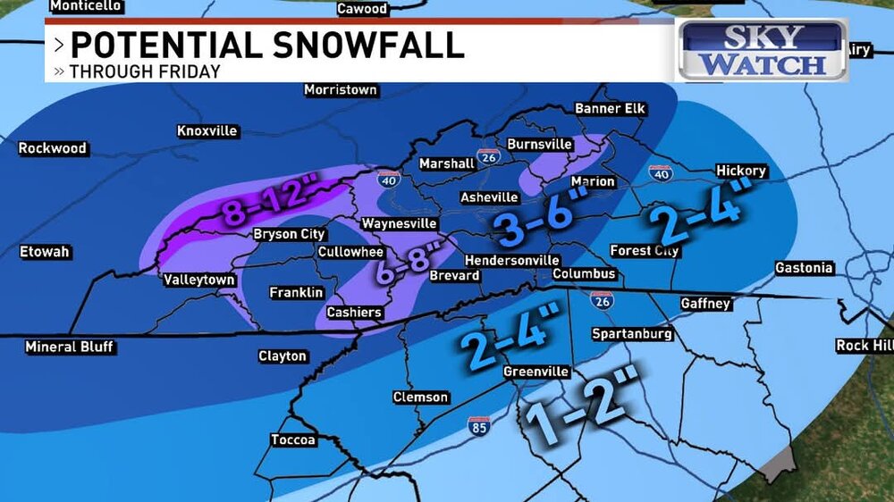
Gonna be some half foot plus totals in WNC
-
HRRR is pretty steady from last run so far. Main difference is its about 3 or 4 hours slower bringing in the precipitation
-
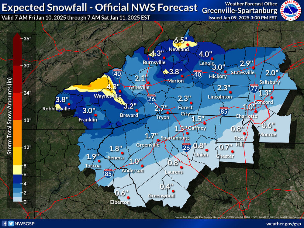
2-8 inches is a big range for the warning.
-
Winter Storm Warning issued for the entire area!
-
I feel confident the streak of futility will be broken. 2-3 inches seems the best bet with some sleet on top.
-
GSP waiting till 330
-
NAM is definitely on its own
-
Euro getting juicier!


.png.82ae88b1fc37e2175c7edf70d2add597.png)

.png.3f5504384f5de8a93adc5240ead14efa.png)
.png.036ab6ff8c7fd231a3975d5de9b94cc9.png)