eaglesin2011
-
Posts
885 -
Joined
-
Last visited
Content Type
Profiles
Blogs
Forums
American Weather
Media Demo
Store
Gallery
Everything posted by eaglesin2011
-
Richmond Metro/Hampton Roads Area Discussion
eaglesin2011 replied to RIC Airport's topic in Mid Atlantic
Yep.. Clouds moving into the area now so temps should start to drop now... See if this area can get lucky with a heavy band tommrow morning & avoid the dry air.. Not like we are missing much if it dosnt happen... -
Richmond Metro/Hampton Roads Area Discussion
eaglesin2011 replied to RIC Airport's topic in Mid Atlantic
Honestly, its not certain yet in the Short Pump area ..Could still be nothing . At this time... Wrost case senerio looks to be 1 to 2 inches, mostly on grassy surfaces... -
Richmond Metro/Hampton Roads Area Discussion
eaglesin2011 replied to RIC Airport's topic in Mid Atlantic
agree that should be no reason to cancel ...Just saying it could still snow going to depend how the two systems come togehter and the timeing/temps.. -
Richmond Metro/Hampton Roads Area Discussion
eaglesin2011 replied to RIC Airport's topic in Mid Atlantic
May not have anything at all but still could get snow in this area.. Its far from certain at this point but either way its shouldnt be anything major, since temps are expected to be right around freezing or above for most of this event in this area ..... -
Richmond Metro/Hampton Roads Area Discussion
eaglesin2011 replied to RIC Airport's topic in Mid Atlantic
After this weekends cold shot, I personaly think we are done in this area with any accumulating snow chances for the month… However a few degrees/miles could be the difference again for the Thursday night / Friday storm… Tomorrow’s high temperature will give us a good indicator of what may come( if anything) if it dosnt warm up as much as expected for those of us just north of Richmond metro.. -
Richmond Metro/Hampton Roads Area Discussion
eaglesin2011 replied to RIC Airport's topic in Mid Atlantic
Probably will warm up just enough to avoid any more snow (except possibly on the very back end of that precip) -
Richmond Metro/Hampton Roads Area Discussion
eaglesin2011 replied to RIC Airport's topic in Mid Atlantic
Yep hanging on to the back edge . Still coming down nicely at the moment -
Richmond Metro/Hampton Roads Area Discussion
eaglesin2011 replied to RIC Airport's topic in Mid Atlantic
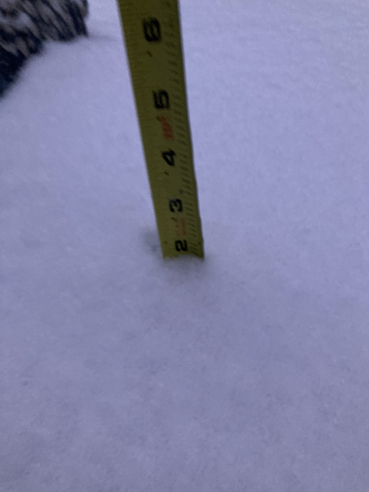
Getting close to 2 inches here in Glen Allen 295 /Staples breaks the streak at least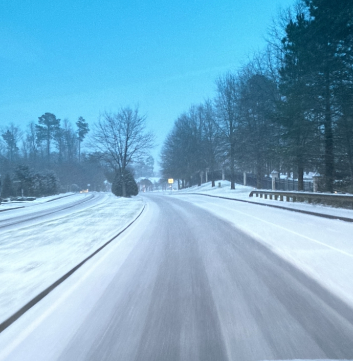

-
Richmond Metro/Hampton Roads Area Discussion
eaglesin2011 replied to RIC Airport's topic in Mid Atlantic
Big last burst started to cave the roads right as this starts to pull away .. -
Richmond Metro/Hampton Roads Area Discussion
eaglesin2011 replied to RIC Airport's topic in Mid Atlantic
Looks like that maybe it for accumulating snow here.. At least we got a decent dusting … pos freezing rain in early morning hours… Travel still could be interesting in the morning at least on the back roads -
Richmond Metro/Hampton Roads Area Discussion
eaglesin2011 replied to RIC Airport's topic in Mid Atlantic
Big flakes now hopefully the turnover holds off a few more hours.. definitely on the line for sure -
Richmond Metro/Hampton Roads Area Discussion
eaglesin2011 replied to RIC Airport's topic in Mid Atlantic
It prob will turn back over from sleet and rain to snow /sleet rain a few times depending on intensity . Again a few miles is going to make a difference of what everyone gets. It’s back to light snow here in my part of Glen allen at the moment -
Richmond Metro/Hampton Roads Area Discussion
eaglesin2011 replied to RIC Airport's topic in Mid Atlantic
Yep first very, light flakes here in Glen Allen -
Richmond Metro/Hampton Roads Area Discussion
eaglesin2011 replied to RIC Airport's topic in Mid Atlantic
Yup precip light snow/rain sleet should start in the next hour or two in the Richmond/Henrico area -
Richmond Metro/Hampton Roads Area Discussion
eaglesin2011 replied to RIC Airport's topic in Mid Atlantic
Banding is definitely going to be key wherever it sets up.. Again, it’s going to be a big difference within just a few miles.. A couple inches to nothing at all.. By 4pm we should be able to see if we are going to be totally screwed or not… -
Richmond Metro/Hampton Roads Area Discussion
eaglesin2011 replied to RIC Airport's topic in Mid Atlantic
The fantasy maps? On one or two model runs? Comon now, let’s be real …lol 0 to 3 inches has been consistent for awhile now on almost all of the models (for this area) Expecting anything more then this with this storm is wish-casting …. (I wish this would happen myself) This afternoon could still bring an inch or two or nothing… YET AGAIN lol -
Richmond Metro/Hampton Roads Area Discussion
eaglesin2011 replied to RIC Airport's topic in Mid Atlantic
4-6 lol? Where are you ? This was never predicted to be that kind of storm in the Richmond area… -
Richmond Metro/Hampton Roads Area Discussion
eaglesin2011 replied to RIC Airport's topic in Mid Atlantic
I wouldn’t expect any real accumulating snow in the Richmond area until this afternoon… Definitely going to be a sharp cutoff & will be hard to predict what the final totals will be depending where the heaviest banding sets up.. Could be a real difference in just a few miles of a couple inches to nothing at all .. Radar at the moment looks pretty crappy (dry air not helping)but the main precip isn’t due till later this afternoon.. Hopefully it can get itself together by then and not warm up (just enough) to be rain or mix at that time.. That will be the key if we get a couple inches or nothing at all in this area… Definitely will be a sharp cutoff. -
Richmond Metro/Hampton Roads Area Discussion
eaglesin2011 replied to RIC Airport's topic in Mid Atlantic
dry air galore -
Richmond Metro/Hampton Roads Area Discussion
eaglesin2011 replied to RIC Airport's topic in Mid Atlantic
Looking like ice could be a problem on Tuesday.. I’d expect school & work closings looks like this maybe starting Monday afternoon/night going from snow& rain back to freezing rain back to snow as it’s pulling away.. What area exactly get dry slotted & how the waves come together or not is going to be key .. More development off the coast could actually mean less snow / ice more rain in this area -
Richmond Metro/Hampton Roads Area Discussion
eaglesin2011 replied to RIC Airport's topic in Mid Atlantic
I STILL wouldn’t write of the early week storm just yet.. The precip in Oregon looks pretty decent . yes, I know it’s expected to die out a bit when it comes across the central US but it looks pretty impressive at the moment. Our luck this thing with get its self together enough to dry slot us and then bomb out farther up the coast.. Watch! Lol -
Richmond Metro/Hampton Roads Area Discussion
eaglesin2011 replied to RIC Airport's topic in Mid Atlantic
Not what I’m saying.. I just don’t know why some are jumping right past todays and Tuesdays storms like they don’t matter .. It is what is going to set up everything & add up to get to the final totals.. Hell it’s far from certain that we will get any accumulating snows out of this So, the “mean totals” really don’t matter until these storms pass.. -
Richmond Metro/Hampton Roads Area Discussion
eaglesin2011 replied to RIC Airport's topic in Mid Atlantic
Don’t get the reason why people keep posting totals for multiple storms that haven’t even happened yet… I can understand the overall totals but hell Tuesdays storm is what needs to set up everything first & really is our best shot for a decent snow that we had around here in years.. -
Richmond Metro/Hampton Roads Area Discussion
eaglesin2011 replied to RIC Airport's topic in Mid Atlantic
On the brink of a decent storm but a slight movement either way could make a big difference…I’m still waiting to see the outputs after tomorrow storm passes.. -
Richmond Metro/Hampton Roads Area Discussion
eaglesin2011 replied to RIC Airport's topic in Mid Atlantic
Anything over a week is just fantasy land to me .. (hell 3 days at most ( Really for me) lol The cold air still being there is what gets the ball rolling for any snow storm…At least that is looking better at the moment. let’s see how the Monday/Tuesday storm does before we jump past it.