eaglesin2011
-
Posts
885 -
Joined
-
Last visited
Content Type
Profiles
Blogs
Forums
American Weather
Media Demo
Store
Gallery
Everything posted by eaglesin2011
-
Richmond Metro/Hampton Roads Area Discussion
eaglesin2011 replied to RIC Airport's topic in Mid Atlantic
Probably a good time to sleep! Looks like a decent break between now & around 6am in this area.. guessing it’s around 3 inches here in my part of Glen Allen but I could be wrong … I could see about the same added later today . (If we get lucky) kinda right on that line here ..(could get nothing) so will see.. This weekend looks to be interesting too, but not ready to talk about that yet until this one is over…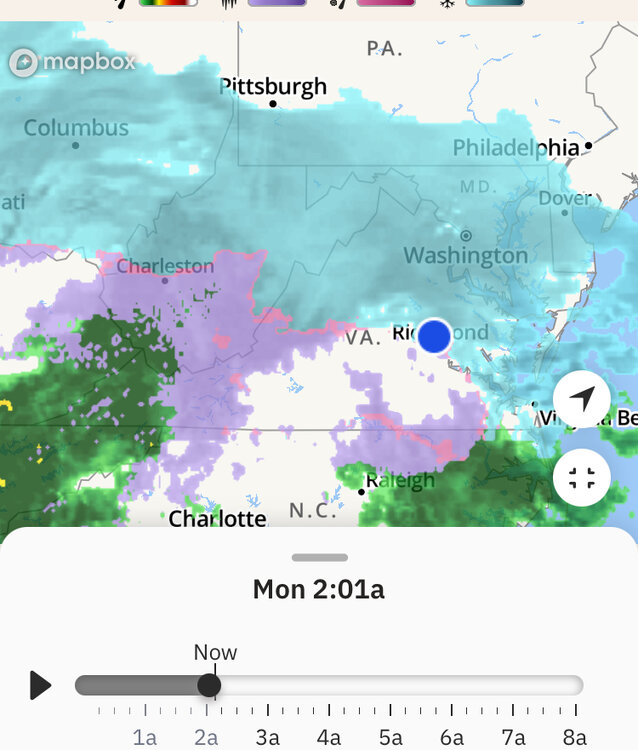
-
Richmond Metro/Hampton Roads Area Discussion
eaglesin2011 replied to RIC Airport's topic in Mid Atlantic
100% before it turns over to anything or shuts off for a few hours.. Why it’s better just to stay where it is for a longer time period (we can only wish) but northern areas prob will catch up a bit more to the southern areas as temps start to warm a bit -
Richmond Metro/Hampton Roads Area Discussion
eaglesin2011 replied to RIC Airport's topic in Mid Atlantic
That mixing around that time is nothing new … you can see looking at the radar things will really start to dry out then for a few hours ..that’s just another reason why being under a good heavy band is key… The powerful thunderstorms are what is drying everything out even more at the moment… We all may not get a real big 2nd thump, if that keeps happening .. unless, we are lucky enough to stay cold enough when the thunder-snow bands move through later tonight/tomorrow -
Richmond Metro/Hampton Roads Area Discussion
eaglesin2011 replied to RIC Airport's topic in Mid Atlantic
It’s all about if your lucky enough to be under a nice heavy banding .. grass isn’t even covered here yet off of Staples /295 -
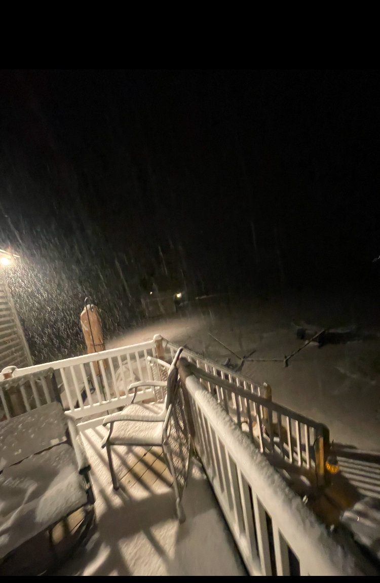
Richmond Metro/Hampton Roads Area Discussion
eaglesin2011 replied to RIC Airport's topic in Mid Atlantic
Picture from Powhatan Va
-
Richmond Metro/Hampton Roads Area Discussion
eaglesin2011 replied to RIC Airport's topic in Mid Atlantic
Wow!!! What a difference it is already from Powhatan Va to just before 288 Capital one rd. Or was a white out with heavy snow in Powhatan .. main rds there already starting to get covered.. I’d say close to a half inch in spots.. once I got past Capital one 288 clear sailing just light wet snow from there to Short Pump so far -
Richmond Metro/Hampton Roads Area Discussion
eaglesin2011 replied to RIC Airport's topic in Mid Atlantic
You can’t really watch the radar unless you actually have something hitting the ground .. most of it is Virga right now, also here in central VA the mountains steal allot of the precip and never make it over or split the percip up.. That’s why whenever the heavy bands set up is going to be key for the amount of snow everyone gets -
Richmond Metro/Hampton Roads Area Discussion
eaglesin2011 replied to RIC Airport's topic in Mid Atlantic
This is why I don’t post much here .. The storm hasn’t even started yet & people are going nutty.. Dry air? that’s always at the start of every storm.. some of you either need to stop drinking or start and come back around 10pm By then there should be some decent action started and a better idea where this will all go .. smh lol -
Richmond Metro/Hampton Roads Area Discussion
eaglesin2011 replied to RIC Airport's topic in Mid Atlantic
I hope you pay double to what ever employee does show up.. (if there is ice&snow) They deserve it .. -
Richmond Metro/Hampton Roads Area Discussion
eaglesin2011 replied to RIC Airport's topic in Mid Atlantic
As I said before.. It almost always will mix here or dry air will always find a way in at some point… Still time for adjustments but it’s a better trend the last few runs with most models .. -
Richmond Metro/Hampton Roads Area Discussion
eaglesin2011 replied to RIC Airport's topic in Mid Atlantic
Salt solution being put down on broad st/ short pump area already fwiw not sure if it’s just to get it down before the weekend rush but seems a bit early to be doing this -
Richmond Metro/Hampton Roads Area Discussion
eaglesin2011 replied to RIC Airport's topic in Mid Atlantic
Anyone who knows anything about the winter weather here, knows that it really takes almost the perfect storm to avoid any mixing in this area & not to be dry slotted at some point. (Even the good storms here get some mixing precipitation for a period of time) how long each will last is key.. We definitely need even more of a southern trend & the cold air to stay in place to avoid the major mixing here … Meaning more snow & then sleet vs Less rain, freezing rain, sleet&snow… I be more worried about the dreaded “sleet storm”here for hrs & hrs here at the moment but it’s still too early to jump on any one conclusion .. -
Richmond Metro/Hampton Roads Area Discussion
eaglesin2011 replied to RIC Airport's topic in Mid Atlantic
Seems like allot to write for something that has virtually no chance of happening but hey, guessing your use to doing it for this forum at this point… lol -
Richmond Metro/Hampton Roads Area Discussion
eaglesin2011 replied to RIC Airport's topic in Mid Atlantic
Most likely still Snow Globe TV for most of the area, if your up in the Early Moring hours.... Temps prob wont even get to freezing in most of the area... So wherever the banding sets up is going to be key if we get any accumulation...... -
Richmond Metro/Hampton Roads Area Discussion
eaglesin2011 replied to RIC Airport's topic in Mid Atlantic
My guess is that we get a a few hours of snow globe flurries or snow showers because of moderate temps & not much moisture .. but hey if a dusting to inch out of it I would call that a win.. .lol -
Richmond Metro/Hampton Roads Area Discussion
eaglesin2011 replied to RIC Airport's topic in Mid Atlantic
Yep, looks like it could be over for thiis month unless we can get a coastal to form & draw in more cold air with one of these systems before the 25th..(even that would prob bring a changeover at some point) the cold air just refuses to come down this way & the precip for early next week looks like to be trying to leave the building now too) A snow shower on the 17th maybe it for awhile around here.... -
Richmond Metro/Hampton Roads Area Discussion
eaglesin2011 replied to RIC Airport's topic in Mid Atlantic
Long ways out still.. I still am ignoring next weeks V Day storm for here.. Maybe we will get some snow tv for a few secs at best (IMO) but again, looking to see what happends behind it and how much cold air it brings in is going to be Key.... The 19-20th storm could be a real boom or bust too... I Like the area it is in now but by this time next week we should have allot better idea of what may happen... -
Richmond Metro/Hampton Roads Area Discussion
eaglesin2011 replied to RIC Airport's topic in Mid Atlantic
Problem is the cold air just hasn’t set in & may not completely for any of these storms… The V Day storm is pretty much certain to be all rain here. Hopefully it will start to pull the cold air down after it.. Then set up the storms starting next weekend… We also don’t want the 20th storm to go too far north .. could start & then end as rain if that happens.. Hate to say it but probably won’t know allot more until after the V day storm passes… At least there looks to be a few more chances in the upcoming weeks…lol -
Richmond Metro/Hampton Roads Area Discussion
eaglesin2011 replied to RIC Airport's topic in Mid Atlantic
Yep…A bunch of teaser systems now showing up on the models starting the night of the 17th through the 22nd. Would still like to see more cold air move in.. Especially if one of these develop more into a coastal as depicted above.. We rarely ever avoid a mix/ changeover when that happens.. -
Richmond Metro/Hampton Roads Area Discussion
eaglesin2011 replied to RIC Airport's topic in Mid Atlantic
Hell for how the last few years have been I’d cash out now for that result in a second if I could. Especially with the marginal temps still on the 19th… -
Richmond Metro/Hampton Roads Area Discussion
eaglesin2011 replied to RIC Airport's topic in Mid Atlantic
Yeah, I saw the 19th chance too .. I would like to see a few models in a row keep the snow chance around before calling it a real possibility… -
Richmond Metro/Hampton Roads Area Discussion
eaglesin2011 replied to RIC Airport's topic in Mid Atlantic
Seems about right to me.. The cold air just isn’t there.. I wouldn’t expect anything wintery around here until around the 22nd the way things are looking right now… -
Richmond Metro/Hampton Roads Area Discussion
eaglesin2011 replied to RIC Airport's topic in Mid Atlantic
nice snow glob snow shower going through Virginia Center Commons -
Richmond Metro/Hampton Roads Area Discussion
eaglesin2011 replied to RIC Airport's topic in Mid Atlantic
got a very light dusting in my part of Glen Allen ... could get another flurry/ snow shower later but wouldnt count on anything more then that... -
Richmond Metro/Hampton Roads Area Discussion
eaglesin2011 replied to RIC Airport's topic in Mid Atlantic
current radar looks decent but really means nothing until goes over the mountains/dry air.....