

eaglesin2011
-
Posts
885 -
Joined
-
Last visited
Content Type
Profiles
Blogs
Forums
American Weather
Media Demo
Store
Gallery
Everything posted by eaglesin2011
-
Yep flurries also now here in Glen Allen
-
Radar already showing us as a snow hole...ha
-
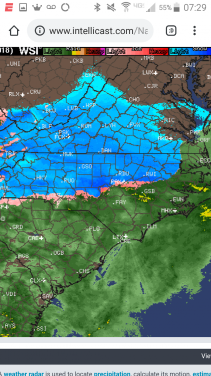
Seems like a good OFFICIAL call for Ric ( Esp how they normally report.).. It looks like the Ric area should be getting close to be reporting the first flurries.. Anybody getting anything yet? Nothing of course out here in Glen Allen near Staples/295. Lok like the rain/snow line is streaching from just south of Charlotte NC to East Just outside Norfolk VA .. Def the sooner this starts the better..The Dry air is gonna be hard to break ...But once it does shouldn't take long to come down steady... I'd say start time prob around 8am in my area but we will see.. LET'S HERE some reports.. Would like to here from people near the snow/rain line also..
-
Thanks compared to this morning a little bump up in % in most places
-
http://www.intellicast.com/National/Radar/Current.aspx?location=USGA0132&animate=true https://www.tropicaltidbits.com/sat/satlooper.php?region=atlpac-wide&product=wv-mid Early radar and water vapor loop Hallucination Yes I know this is the intellicast radar but you still can see how far the precipitation is getting ... Def making it bit father in west TN then east. . Hopefully we can start bumping that up on the east side... On the water vapor nice blow up on the south side
-
Yeah that's what I saw..post it if u see it updated.......Even tho much more over 6 I think will be a long shot in most of that 4-6 area
-
Did they update the 6 or more % yet?
-
Btw they started on the roads 2 days ago... But with that last few runs it's not gonna matter much whats on it.... Again... we may have to start hoping for less of a jog North soon.. ugh I'D CASH out now if I could if it guaranteed what that last NAM run showed. .ha
-
They Must of slept in.. Now bow your heads for no dry air/or long period of sleet/rain
-
The airport (RIC)must of taken over the offical warnings from Wakefield. .So it can be as bad as their offical snow readings..
-
Ric Airport ...True but even with a low est 1-3 /ice threat a WWA should of been issued at least this morning Thats been known for hours now...
-
STILL not even a winter weather warning for the Richmond area yet... ha..a joke guess they will wait till 5pm
-
Still no offical bump yet..... obviously just going with the American model..Mix
-
Well that's normaly the case... Avoiding the dry air/mix is always a fight here... The storm really getting going kinda scares me... Because that is what it normally brings along. HOPEFULLY when/if the heavy precipitation moves it will be all snow & we will cash in..
-
Oh I do.. Being also an Eagles fan... Tomorrow could be a complete win/fail
-
Watch us in Richmond will manage to get into that dry air / sleet fest somehow. Ha
-
Ha we can only wish... I would keep an early eye on the Knoxville TN area if decent precipitation/snow gets North of there it should be a good sign for our area.. Hopefully we can hold onto the cold air snow/mix line is going to be key... With the new model data... I would expect an advisory at least, should be coming out around the noon hour today for this area. Even if it's a mix for a period of time...
-
OK sorry lost track of time that's still last night runs..
-
Got a map ... didn't see it... Would like to see at least an advisory pop up soon.. Def looks like it's going to move across sooner then later
-
It gets into Richmond a tad warmer tho so not sure how that will play out with totals. Looks like a little more spread out to the se to me..
-
yep prob half will be sleet but Ill still take that even that if it happens...
-
Well me might of been just jinxed .... Roads getting BRINE put down already
-
https://www.tropicaltidbits.com/sat/satlooper.php?region=atlpac-wide&product=wv-mid very good view of the action getting going here... Hopefully that dry air dropping down is out before we get the main storm coming in.... I still think we can get lucky and pull off a 3-6 storm for most of the RIC area... PROB most in a quick burst overnight Sunday... Bust potential still there of course for a sleet /mix fest ..
-
DT really pushing stronger storm N snow shield trend.. ESP in the Richmond Area... (per his facebook site) his quote.. "Cutting edge stuff"
-
umm is it happy hour already?


