

eaglesin2011
-
Posts
885 -
Joined
-
Last visited
Content Type
Profiles
Blogs
Forums
American Weather
Media Demo
Store
Gallery
Everything posted by eaglesin2011
-
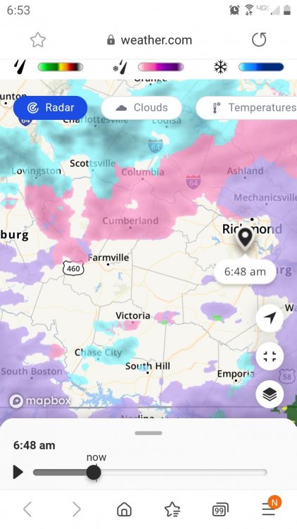
Looks like another 1/2 hour or so until we get back into a more steady precip in most of the Ric area..... I actually think late tonight maybe the worst of it.. Looks like the 2nd batch is TX is a little more put together at the moment. .. So its definitely something to watch.
-
Already hitting a dry patch radar pretty scattered at the moment..That's prob a good thing since it's mainly freezing rain /sleet at the moment with a few flakes mixed in every now and then . Will see how long it takes to fill back in but any low like this is a good thing.. Looks like a decent low tho until 8am or so...
-
You care about people in southern VA why? People in northern VA /DC dont care about you... Lol Btw down to 32 already here in Glen Allen
-
The clear sky's really brought the temps down wick 34 now here in Glen Allen. Is the storm moving slower then modeled?
-
Would be nice if we can catch a heavy band of snow before the turnover like the one in Nashville TN at the moment. Of course that may only make things worse ...if we again get snow ,sleet ,and freezing rain on top of it all.. Definitely gonna be interesting. I really believe we are going to be in for a sleet fest once the turnover happens for a few hours at least..
-
Yeah, that's still all the same...The 1-4 is western areas outside of Glen Allen/Ric ..pretty sure it's been 1-4 for awhile now in those areas..
-
Did anything change from the last warning? Dosnt look like it to me for our area???
-
Well your Also in Ashland right? It's a big difference from Richmond where its reporting 41 Its 40 at the moment here in Glen Allen
-
I was about to say the same thing.. Guess it's a running joke where the cut off line just happens to be for decent measurable snow.. Its funny how some people take weather so personal ..(like any of us can control it. Lol
-
Anyone know if portable Generators are available anywhere? I looked online and the earliest I could get possibly get one at Lowes was Saturday... Thankful last storm my power only went out for a few mins. Hopefully we avoid the worst again..
-
Its 50 now but doubtful we will get into the mid 50s at this point
-
Yeah, this is starting to look like the normal sleet fest that we normally get around here.. Maybe a couple inches before change over to sleet the freezing rain/rain Today will be interesting to see how warm we get ...Forecast is mid 50s .
-
For once, I wouldn't mind a sleet fest, seeing that much possible ice...I rather have the damn sleet.
-
I cant stand that DT guy either.. He makes people believe that he is seeing things weeks ahead but obviously its the models.. Then blames it on them when his forecast bust... Anyways... I think he has saying the ice wont be as bad here because he believes we will have snow and or sleet that cuts down the ice...
-
Looks to me we are going to get a major ice event here or almost a carbon copy of the last storm with snow then ice to maybe rain.. definitely trending more to a ice and or snow event.. Will see how much it warms up tomorrow, still a little snow pack hanging on here
-
Ice is allot worse then a foot of snow. Thankfully main roads arent that bad at the moment . Trees look to be the biggest issue going forward..
-
Richmond News | Richmond Times-Dispatch | Richmond, Virginia news, business, sports, entertainment, restaurants, events, arts and shopping https://richmond.com/
-
Just do a screen shot of your picture then try to resend. Should work that way
-
Got any pics? Guess it's a good day to start my taxes. Joy!
-
Pretty sure its Ashland
-
Yeah still early in this storm I'm in glen allen /295 Car icy but treated sidewalk is fine. Main roads fine of course could be that occasional icy spot. Side roads icy.. Trees look to be the main issue... some seem ok, others that had more snow pack are stating to be weighed down a bit.. To me, tonight when temp drops again are going to be the key timeframe before the warm up again tomorrow
-
Even if that's the case... light plain rain, could also put weight on the limbs that already snow covered at first... To me....if there wasn't already snow on my of the lines and limbs, it wouldn't be that big of deal.. But there is...
-
Ha there is already is a nice coating of ice/snow on almost all of the trees....This is why it's not going to take much to cause issues... That DT guy gets way to wrapped up in the modles .. Anyone with half a brain can see if we get frozen precip on what has already fallen it will cause issues..
-
You may get to that myself and the city will be lucky to make 3 inches. I doubt I'm much more then an inch here in glen Allen
-
Finally decent enough rates to start accumulating again .


