

MD Snow
-
Posts
1,875 -
Joined
-
Last visited
Content Type
Profiles
Blogs
Forums
American Weather
Media Demo
Store
Gallery
Everything posted by MD Snow
-
Temp down to 36 from a high of 41 an hour ago. 5 degree drop in an hr isn't bad for just south of baltimore. I think the favored areas will do just fine. Light snow still.
-
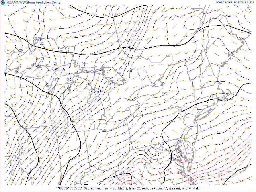
850's still draped through central Virginia into the south central delmarva. 925mb temps draped through calvart county into the central delmarva. Where they set up later this afternoon will have huge implications on where the cutoff for accumulating snow will end up. Areas that remain below 0c have a good chance of getting the r/s mix to switch to heavy snow when the good stuff comes in after 4pm. The window for accumulating snow for areas just to the north/west of the cities will be sometime after 4pm imo. Will take time to cool things off after having road temps in the upper 30's/low 40's.
-
Light snow. Temp has dropped from 41 to 39 in the last 15 minutes. Bar for this was seeing flakes for me. I was concerned about it being an all rain event.
-
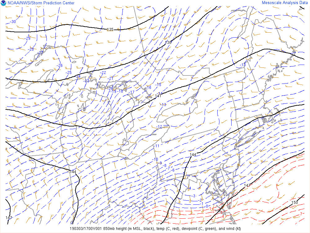
Latest 850 and 925 mb temps.
-
Light snow has started here in Glen Burnie. 41/31.
-
Slightly colder at onset but overall just noise as it still shows areas north and west of dc/balt as all rain.
-
FWIW...12k nam coming in snowier for the cities at onset...
-
Is this what we want though? Flurries and light for a few hrs as dews warm? I’d rather the light stuff just hold off until the heavier stuff arrives this afternoon.
-
We still got a shot at something on Friday. Would be nice to have some good looks at 12z and 18z to hold us over if it does just rain. Holding steady at 39.
-
Most recent 925 and 850 mb temps. As long as you are below zero with these, I think you've got a decent shot at mixing some snow down. Would think you'd need to be -2 or -3 c for all snow, given the warm surface and the warm push from the coastal.
-
All the mesos have pretty much lost the idea of starting the cities as snow. They keep the cities south and east rain for almost the entire duration. Yesterday many of the mesos had the cities starting as snow for a few hrs. Temps are really warm as well. 40/26
-
44/35 here.
-
Hrdps is a hold if not slightly better.
-
Like how the rgem and gfs flip everyone back snow on the back end. That would be nice.
-
the 6hr maps on tt never change Baltimore to rain on the 18z gfs.
-
Fwiw euro does snow in dc from about 10am-2pm. Baltimore from 10am-3pm and then mixes from like 3-5pm before changing to rain.
-
NAM's came ever so slightly south. ICON and RGEM went ever so slightly north. Early on GFS appears to be coming north slightly to be a hold. It's a pretty easy forecast imo. 95 north and west have the best chance at accumulating snow. Carrol and Frederick and northern baltimore counties appear to be in the bullseye.
-
It's actually worse for the cities compared to 6z. One way or the other you have the best shot at 5+ even with the shrinking precip shield. If i was out towards winchester and hagerstown I wouldn't be digging the shrinking precip shield right now.
-
Yeah it’s been pretty steady. Definitely more amped this go around. Furthest west it’s been in days.
-
The Nam snow maps were showing 2-5” for last nights coastal pretty much region wide fyi...even with that things have been looking drier.
-
Those included snow from last night.
-
snow maps, blah. 6z looked better even easter of the cities.
-
Yeah, 3k is like 1-2" on grass for cities followed by rain. At this point i'd take that. 95 north and west stay mostly snow. Slight improvements on both NAM's. They are slightly drier though compared to 6z. Interested to see what the RGEM and HRDPS show...
-
Looks pretty heavy to me when it starts...enough to whiten everything up.
-
12k is a nice front end thump before changing to rain for the cities. PSU’s dream for his back yard.
