OSUmetstud
-
Posts
16,521 -
Joined
-
Last visited
Content Type
Profiles
Blogs
Forums
American Weather
Media Demo
Store
Gallery
Everything posted by OSUmetstud
-
Hmm. I see a bunch of posts from the last page or two that dont say that at all.
-
Winter has been more half and half I believe lately but definitely better to go "orange" every other season lol.
-
They have plenty of mjo and enso regression analysis on their website. They're not just blending models or using the cfs. They know just as much as anyone else out there re: seasonal forecast which is still to say not that much.
-
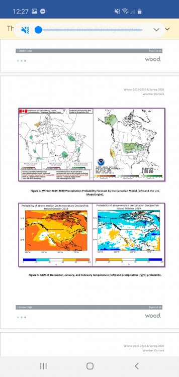
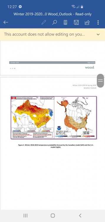
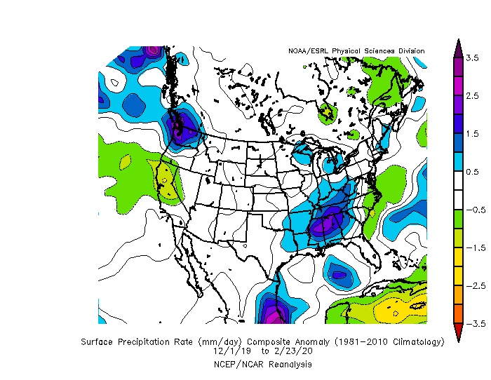
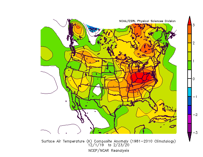
The ukmet and ecwmf seasonal were both good highlighting that wet area over the southeast in their October forecasts. I believe generally all the agencies and models were too cold over the north-central us.
-
For further illustration.
-
Cpc had equal chances across the northern tier/western great lakes and warm anomalies for the southern 2/3 and the pac nw and new england in the fall in advance of winter. It's actually the only area of the country they missed on because they were too "cold." They missed the high precipitation anomalies across the southeast. Did well with the precipitation anomalies in the great lakes. They also missed the positive precipitation anomalies in the pac nw. Good forecast this winter overall I'd say.
-
The cpc is not always above. I'm not sure why people feel need to throw shade without facts.
-
Upstate/Eastern New York
OSUmetstud replied to BuffaloWeather's topic in Upstate New York/Pennsylvania
Cool. Good memory heh? Lol -
Upstate/Eastern New York
OSUmetstud replied to BuffaloWeather's topic in Upstate New York/Pennsylvania
18z backed off though. Just something to consider before going all-in on a foot or something from the synoptic portion.

-
Upstate/Eastern New York
OSUmetstud replied to BuffaloWeather's topic in Upstate New York/Pennsylvania
Feb' 58 I think was also in the high 20s. Must have been mostly lake enhancement since the storm was a classic offshore nor easter. -
Upstate/Eastern New York
OSUmetstud replied to BuffaloWeather's topic in Upstate New York/Pennsylvania
I thought was like 21"? -
Upstate/Eastern New York
OSUmetstud replied to BuffaloWeather's topic in Upstate New York/Pennsylvania
I'd keep expectations in check for the Niagara frontier. Doesn't scream a really big one to me. Dont fall for bad gfs runs. -
Upstate/Eastern New York
OSUmetstud replied to BuffaloWeather's topic in Upstate New York/Pennsylvania
Hmm Feb 84 was a traditional synoptic storm with LO enhancement in northerly flow. No enhancement from the SW. I'd probably consider it BUF's largest synoptic storm.
-
They're having a shitty winter too.
-
Winter 2020 New England Banter and General Obs
OSUmetstud replied to CapturedNature's topic in New England
I see the news articles but idk. 20 ft is a single storm? Color me skeptical. -
Cra(y)zy
-
Yeah I think northern Maine, northern New Brunswick, and eastern Newfoundland are the only places with significant positive snowfall anomalies in eastern North America lol.
-
Does anyone know of any publicly or subscription based EPS/GEFS/GEPS combined products?
-
Visiting my brother his wife and my niece at fort gordon. But yeah.
-
0 I'm in augusta ga lol. The airport has embarrassingly bad obs sometimes...reporting 15". Its wrong. The mt pearl cocorahs is reporting 49" lol.
-
I hope so.
-
I guess it's how you look at it. The fact that were in a historic +ao regime but still low on ice is a bad sign too.
-
It should increase in a +ao regime. Even with the uptick this winter due to that it's still on the very low side compared to norms.
-
The 40 cm subsurface temperature across nova scotia is near freezing on average and only above freezing in far southwest areas. If you post "warm ground" arguments in southeast canada in late feb and march you should get your ****ing degree revoked.
-
Major Winter Storm 2/6-2/7 OBS
OSUmetstud replied to PaulyFromPlattsburgh's topic in Upstate New York/Pennsylvania
Yeah looks like it.