OSUmetstud
-
Posts
16,521 -
Joined
-
Last visited
Content Type
Profiles
Blogs
Forums
American Weather
Media Demo
Store
Gallery
Everything posted by OSUmetstud
-
We concern
-
Euro always has a slight SW bias with tropicals. It just seems more enhanced this year.
-
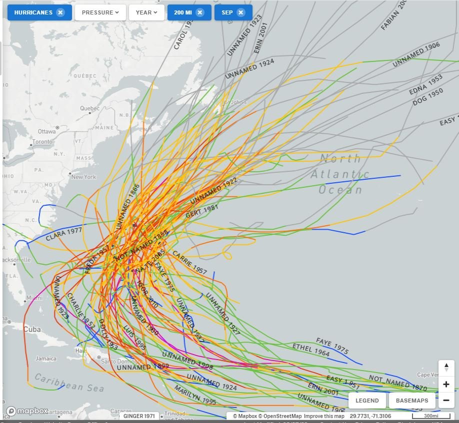
Same but for 200 NM. ECMWF/EPS as modeled is a very unusual track. Could happen, but something to keep in mind when looking at model solutions.

-
That's Ginger (1971). A really weird one.
-
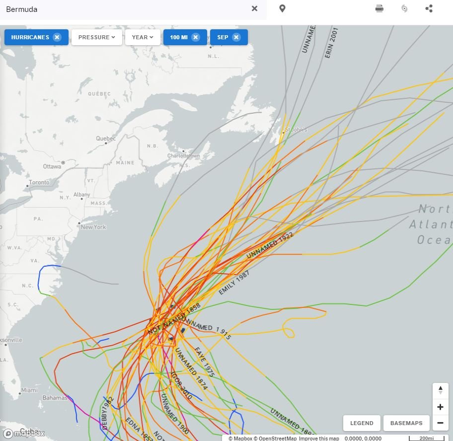
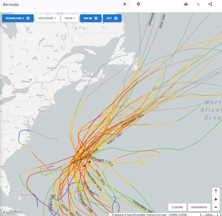
Hurricanes passing with 100 nm of Bermuda in September.
-
If the cut off continues, it must just fill south of the ridge and turn into shit and then get kicked out gradually.
-
hmm, alright. Well radiation math isn't my strong suite lol.
-
So the sun heats up the particulates in the lower and middle atmosphere leading to unforeseen sensible heating that raises 500mb heights? Idk, seems a little far fetched. Smoke afaik results in a net cooling effect overall as it blocks incoming shortwave radiation from the sun, but does not stop earth's longwave radiation from escaping at night.
-
We still cloud seed. It's done in drought areas to attempt to produce precipitation and to reduce hail size. You can see the planes flying during the summer in southern Alberta when large hail is expected. I don't know how any of that would scale to a larger system, probably not well... http://www.wmiradar.com/ahsp/index.php?time=current_run&type=still&model=wrf&var=maxmap2_meanhail
-
Yep agreed. Weird that it had a bonafide hurricane with Paulette on the 00z run last night near Bermuda but it has since kinda gone back to a middling tropical storm type low.
-
UKMET was the best with Laura. I posted the Albany stats in that thread. GFS outperformed ECMWF for Laura, not sure if that's true for the season as a whole though.
-
Can you post a link? I know it's been struggling with TCG but I would find it a bit hard to believe the routinely best track model is now the worst this season.
-
I just don't see how methodology like this really holds much weight. It's interesting, historically speaking, but as a meteorologist, and someone who watches the tropics on a regular basis, why would I throw out all the experts who continue to believe this season will be very active.
-
I wouldn't sell the hurricane seasonal already based on low ACE production so far given the potential.
-
Preliminary, but 2008-2009 looks like a decent analog for the coming winter, I think.
-
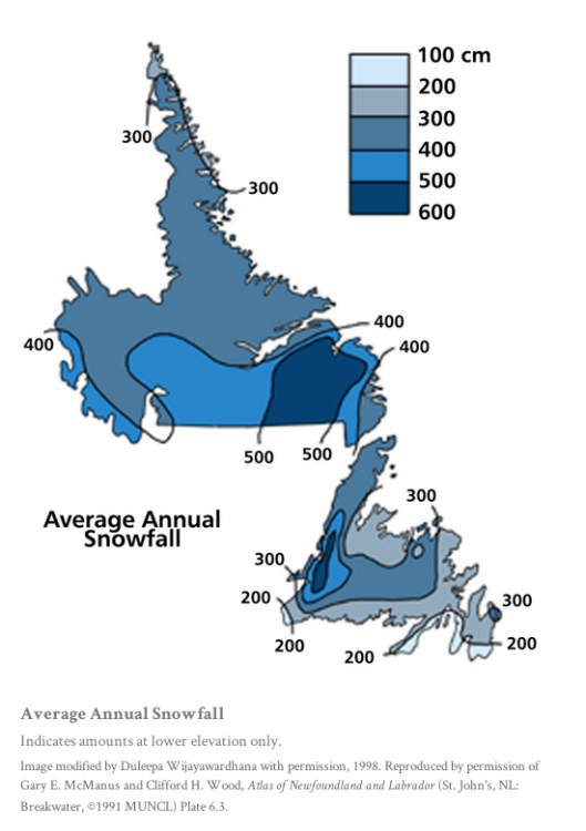
I think that's fairly conservative, overall, like I'd be surprised if the Baie Verte Peninsula on the north coast there averages less than 300 cm per year.
-
Rodney Barney ECCC Met in Gander posted this on twitter last year.
-
Hey, this map is really awful for Atlantic Canada lol. That area from Halifax to south of Yarmouth averages below 200 cm. Interior central and northern Nova Scotia, and northern and eastern NB does not average over 400 cm, the only place that probably would is the "mountains" of central/northern New Brunswick. Saguenay, Quebec, Rimouski, and Gaspe all average under 400 cm. Some of the mountains of Western Newfoundland probably average just over 800 cm.
-
Spain having big problems again.
-
Upstate NY Banter and General Discussion..
OSUmetstud replied to wolfie09's topic in Upstate New York/Pennsylvania
You would have to know potential long term effects, which we don't because the disease has only been around for 6 months. -
Upstate NY Banter and General Discussion..
OSUmetstud replied to wolfie09's topic in Upstate New York/Pennsylvania
How about Germany? -
Upstate NY Banter and General Discussion..
OSUmetstud replied to wolfie09's topic in Upstate New York/Pennsylvania
That's for vaccine research and it hasn't been done because it's unethical. There's enough covid around in the US to get a solid control arm without having to challenge. -
Upstate NY Banter and General Discussion..
OSUmetstud replied to wolfie09's topic in Upstate New York/Pennsylvania
Plenty of the other countries economies are doing relatively well that have the virus under control. The US seems to like to have the worst mix of both. -
Upstate NY Banter and General Discussion..
OSUmetstud replied to wolfie09's topic in Upstate New York/Pennsylvania
It's ****ing insane, no government or public health expert thinks that's a good or reasonable idea. Good lord. And that's not true, only less in kids. -
Upstate NY Banter and General Discussion..
OSUmetstud replied to wolfie09's topic in Upstate New York/Pennsylvania
Swedes are not acting like they normally would before the pandemic...just like other places in the world. You can look at the mobility and open table data.