OSUmetstud
-
Posts
16,521 -
Joined
-
Last visited
Content Type
Profiles
Blogs
Forums
American Weather
Media Demo
Store
Gallery
Everything posted by OSUmetstud
-
https://twitter.com/webberweather/status/1839293980367864089?t=6asHJsTir6tWlG6viX593Q&s=19
-
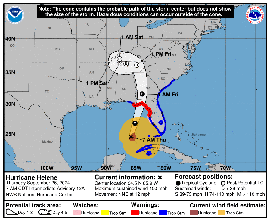
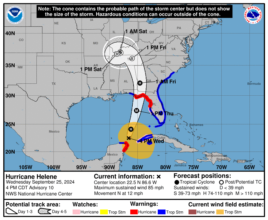
I'm talking about the landfall location. It's barely moved
-
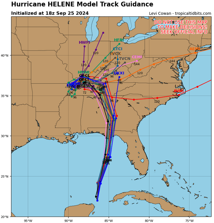
The spaghetti plots there is just the operational models corrected for current position to get the best forecast possible. The euro gfs and the tropical models are all there getting the same adjustments. Its been done for years and it improves forecast error. These are yesterday's 5 day track and today's. It's barely moved.
.png.118b80ca21d67639e19034a5c36018e6.png)
-
This was all explained yesterday. Hasn't the track only moved like 20 miles east? The nhc uses the corrected models because it's the best tools we have. What else do you want them to use?
-
It's gradually strengthening but it's not going to really take off until it has a better inner core and a smaller rmw.
-
The noaa3 plan recon is at 750mb not 700mb but it I think it still supports about 90 kt surface.
-
So 2 mb drop in 97 minutes between sondes
-
They can cover their ass a bit. The 18z weakening makes sense to the current state but it could still hit 4 before landfall 7-8 hours later.
-
85 kt flight level in se quad on current pass. That's the highest yet.
-
It's funny how east it went initially but then kinda got to the same landfall point in the end
-
The 18z early cycle ecmwf was adjusted westward already. It's one of the blue models on the right edge of this map. That's the forecast that the error calculations would be using.

-
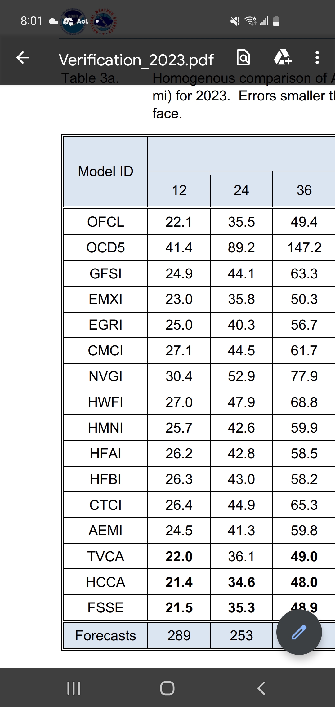
These are last years atlantic homogeneous track errors at 12, 24, and 36 hours which might have some relevance. Best are nhc, tropical concensus, and ecmwf
-
It's not really. The tropical concensus type models which are typically the best blend in a good deal of euro and euro ensemble already and adjust for known biases
-
I dont believe the icon is used whatsoever in the tropical model suite that nhc uses. And that 18z early cycle models shown here are being adjusted for current position which might pushing the tracks farther west than the raw 12z models.
-
Theres no issue with the nhc forecasts. They are consistent with the hurricane models in terms of track and landfall position.
-
This is from u of Wisconsin Consequently, "early" models represent forecasts from the previous cycle - that beginning 9 hr prior to an official forecast - that are shifted forward in time by 6 hr with a position and intensity matching the storm's current attributes. For dynamical models, these models have designators that end in an I (e.g., AVNI, CMCI, etc.) to indicate their interpolated nature. Note that consensus, statistical, and statistical-dynamical guidance is also classified as "early" guidance since each are derived using "early" model inputs. Conversely, "late" models represent forecasts from the current forecast cycle that arrive late, or after the official forecast must be made. They form the basis for the next forecast cycle's "early" model forecasts. They have no special designator notation.
-
18z early cycle models are 12z models corrected for the current position
-
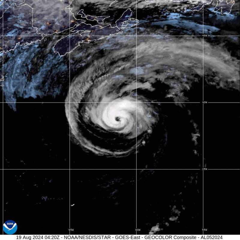
This et transition is pretty fake...strictly from ssts and convection lost for now. It's still very muggy this morning here. No cool and dry air advection on the backside. Sig seas up to 9.6 m at hibernia and 10.3 m at hebron this morning. https://x.com/rcbstormpost/status/1825850277015982085?t=CgGmoxq6q8_phAUbGVI5oA&s=19
-
This will likely be the station with the best surface obs as Ernesto passes makes it cpa over the next few hours. https://capebretonweather.ca/station.html#id=001D0AE0065C
-
No. It's tracking well south of there.
-
18z best track is still 80 kt
-
12z best track is 80 kt
-
I'm guessing they'll go with 85 kt cat 2 as of 12z best track but we'll see. That's more of a blend of tafb and cimss data. Reasonable chance it will be weaker even by the 1100 edt advisory given ssts now decreasing along the path.
-
So close to a real good smack.