Tatamy
-
Posts
2,585 -
Joined
-
Last visited
Content Type
Profiles
Blogs
Forums
American Weather
Media Demo
Store
Gallery
Everything posted by Tatamy
-
They formed east of there. No worries as there are others popping up all over the place around here.
-
They have an old narrow truss bridge across the Delaware River at that location. No EZ pass there. They hire senior citizens to stand in the roadway and collect the tolls from motorists.
-
These storms are already east of there.
-
They are popping around me as well. Outflow boundary passed me about 10 minutes ago and dropped the temperature about 8 degrees in a few minutes.
-
Active convection day in NE PA especially in Monroe and Northampton Cty’s near Stroudsburg. These storms are severe warned and are moving into Warren and Sussex Cty NJ at this time. 211 lightning strikes in the past 3 hours with these storms. Use caution if you are driving out west on I80 in NW NJ this afternoon.
-
 From a meteorological perspective Sandy was a hybrid storm for a good part of its existence outside of the Caribbean. It comes down to the realization on the part of the NHC that both subtropical and tropical storms can be highly destructive. At the end of the day the public needs to be warned in advance of a system that can bring high winds, storm surge, and heavy flooding rains. Both of these types of storms can do that. Up to about a decade or so ago only tropical systems were named and subtropical ones weren’t unless they became tropical. Now both are and the process/experience with how Sandy was tracked and the agencies responsible to do so were crystallized. A true hurricane is defined by its scientific/meteorological characteristics and the definition is not going to be changed for the sake of issuing warnings. That is why we have the current system in place. Regarding the Saffir/Simpson scale, this was developed by pioneering tropical meteorologists back in the 60s and 70s. I believe it serves its purpose well. To relate the scale to wind increments of 5 mph makes no sense. The purpose of the scale is to relate the wind speeds and overall intensity of it to the potential damage and it can and does cause.
- 1,603 replies
-
- 1
-

-
- hurricane gusts
- flooding rains
- (and 2 more)
-
I was outside of my house that night listening to it roar overhead. I have never heard anything like that before or since.
- 1,603 replies
-
- 2
-
-
- hurricane gusts
- flooding rains
- (and 2 more)
-
It’s amazing how short people’s memories are. Numerous wind gusts to hurricane force across LI including 90 mph at Islip. Just about Every road and train tunnel to Manhattan flooded out. 53 people dead in NY. $40 billion + in damages. Massive damage along the NJ shore. With regards to its status at landfall I think that had to do with politics. Insurance companies had to pay more due to it being classified as other than a hurricane (my opinion).
- 1,603 replies
-
- 1
-
-
- hurricane gusts
- flooding rains
- (and 2 more)
-
How about Sandy in 2012?
-
No full moon out here. The moisture from Henri has circled all the way around from CT, SE NY, and northern NJ and found it’s way to eastern PA. It’s been pouring out here tonight after a drizzly day. 2.01” on the day so far.
- 1,603 replies
-
- 1
-
-
- hurricane gusts
- flooding rains
- (and 2 more)
-
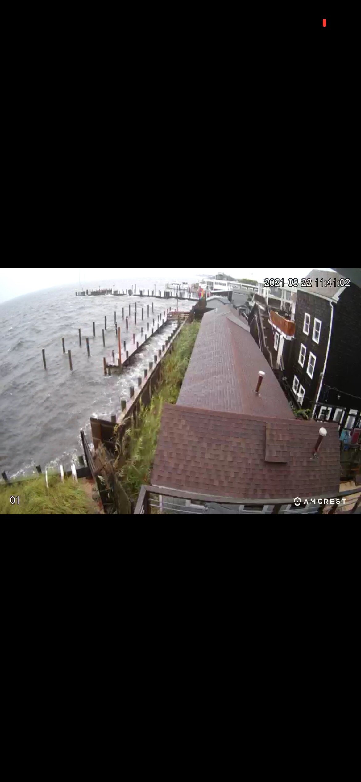
The attached photo is of the ferry dock at Cherry Grove on Fire Island. The dock is typically at least 3’ above the mean water level. In this shot it’s almost even with the dock. It looks like the storm surge warnings verified.

- 1,603 replies
-
- 1
-
-
- hurricane gusts
- flooding rains
- (and 2 more)
-
Pressure now down at SE light to 989 mb.
-
I am sorry- I was referring to the location of the station as being on Block Island and using BID as an acronym. My bad.
-
No - they are from a station on WU at Southeast Light at Mohegan Bluffs. It’s a Davis Vantage Vue mounted on a pole on a roof top.
-
Pressure at BID down to 992 mb. Recent wind gust to 68 mph.
-
BID just gusted to 66 mph.
-
You have to go out to eastern Suffolk to find strong winds. I found a station out in Baiting Hollow at Reeves Beach on WU overlooking the Sound with a recent gust to 49 mph.
-
Following two WU stations on BID as the NW eyewall of Henri approaches. Highest gusts are 54 and 56 mph.
-
Following two WU stations on BID as the NW eyewall of Henri approaches. Highest gusts so far are 54 and 56 mph.
-
I checked the Davis site for stations in midtown. Multiple reports of 1.5 to 2” with one report of over 3”.
- 1,603 replies
-
- 1
-
-
- hurricane gusts
- flooding rains
- (and 2 more)
-
I looked at the Davis site for stations in midtown. Multiple reports of 1.5” to 2” so far. One report of over 3” posted.
-
That was related to the sting jet that set up to the south and west of the center.
-
Total opposite out here in Bethlehem PA. Full sun, hardly a cloud in the sky, and calm winds.
-
The NAM led the way east a few runs ago. Now the 06z NAM says I don’t think so. This track has been closely related to the intensity of the storm. In the 5am advisory the NHC noted that the shear is finally beginning to relax. I am guessing that the NAM is seeing that and the resulting greater intensity potential and hence the move back west. If the storm does intensify today there could be some potentially threatening model runs for LI and the remainder of the region. In any case the strongest winds with this event will be felt along the south shore and the east end particularly along the barrier beaches. At 5am the NHC discontinued the hurricane watch for most of SE MA including Cape Cod. They reiterate that conditions will be favorable for strengthening for the next 12-18 hours. Hurricane conditions are expected to begin late tonight or Sunday for parts of LI and CT. The next recon is due into the storm at 1200 UTC.
- 1,603 replies
-
- 3
-
-

-
- hurricane gusts
- flooding rains
- (and 2 more)