Cheeznado
-
Posts
2,155 -
Joined
-
Last visited
Content Type
Profiles
Blogs
Forums
American Weather
Media Demo
Store
Gallery
Everything posted by Cheeznado
-
New GFS is bonkers!
-
I posted some neat contrail photos on my photo page https://www.facebook.com/cheeznadophoto a couple of days ago and boy howdy! Talk about the inmates escaping the asylum! It- generated a ton of wacky (and worse) responses regarding how contrails and cirrus clouds don't exist or disappear within minutes, the gummint is controlling the weather through geo engineering and all other manner of crazy stuff. I knew these nuts were out there but to see it first hand was quite illuminating nonetheless. No wonder the world is going to hell in a handbasket.
-
Southeast Sanitarium - Winter 23/24 Edition
Cheeznado replied to eyewall's topic in Southeastern States
Dr. No makes a comeback. No snow in GA except up along the border. Yawn. -
This was a pretty bad bust, SPC did downgrade the risk late yesterday but so far not one tornado report, and nothing even severe currently after some wind damage the AM in Mississippi. All along the CAMs had few if any UH tracks, and the instability was very meager.
-
Moisture is the big issue, models still differ on how much will make it how far north. Dynamics off the charts with ludicrously high SRH values, so a raging squall line is very likely at the very least. Another bugaboo for chasers are the insane storm motions, 60-70 mph. If I were local it would be worth a shot but there will be much better situations down the road.
-
One thing to keep in mind is that ground temps will be quite warm, surface temps may be a tad above freezing even during some of the snow (except in the mountains), so a lot of melting will occur, so accumulations at least on many surfaces will likely be less that what the models are showing. Further melting will happen soon after the event occurs since there will be no real cold air once the ULL departs.
-
Actually this came in in second place, still impressive.
-
San Francisco just set its all-time 24 hour rain record. Moderate to major flooding ongoing in several locations. Up to 10" of rain in some higher spots. And this is just from the first system!
-
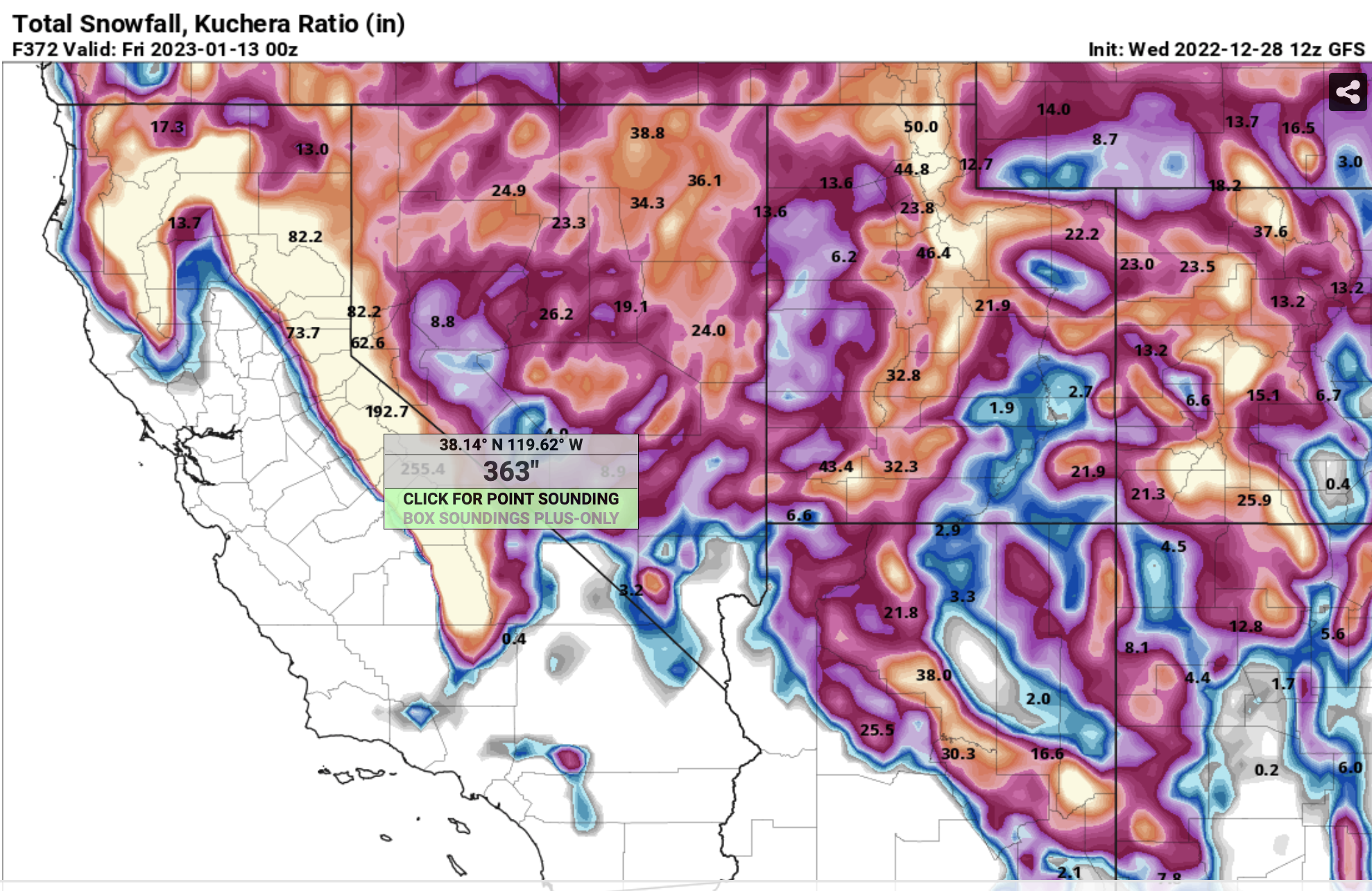
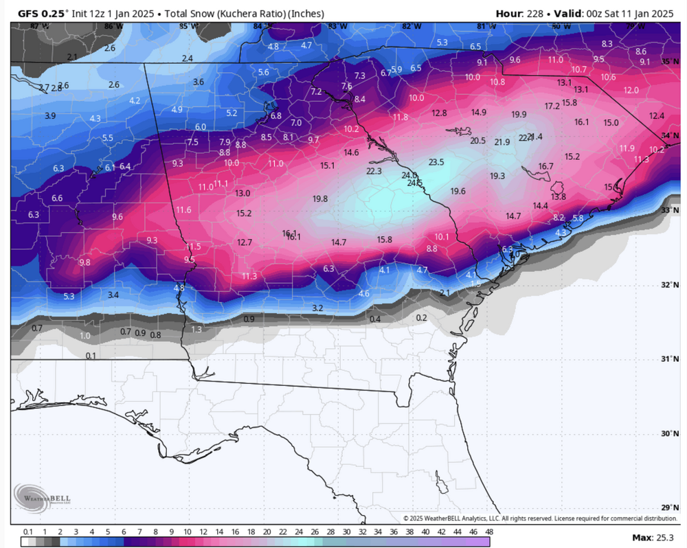
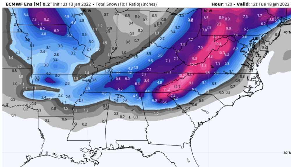
Extremely good model agreement on an epic pattern for the West Coast, especially California. Yes, the attached is a very likely overdone GFS snow total map for the next 15 days but 360" of snow?????? The ensemble mean is much less, but much less in this case is still AOA 150""

-
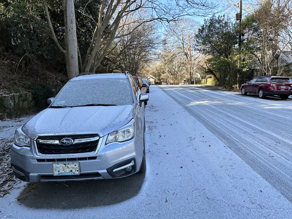
This is a late posting but very early Tuesday we got a nice dusting here.
-
The biggest thing with this is the cold, wind chills in the Atlanta area will be as low as -10 both Friday AM and Friday night. No above freezing here from overnight Thursday/Friday AM to Sunday afternoon and then only barely. Snow wise just flurries briefly behind the front. Not impressed with the following system, too positive tilt.
-
Everybody take a deep breath. The fact that this is so much different than the previous run and light years different than the 00Z Euro makes me highly skeptical. I think someone may get plastered, sure, but posting all these clown maps is just getting everyone into a tizzy way too early in the game, Now if the ensembles and 12Z Euro trend this way, I may get just a bit more interested.
-
Sleet in Atlanta IMG_1383.MOV
-
Potential 1/28-1/30 2022 winter storm
Cheeznado replied to Prismshine Productions's topic in Southeastern States
How about Long Island? 37" to not a flake in one run! -
Potential 1/28-1/30 2022 winter storm
Cheeznado replied to Prismshine Productions's topic in Southeastern States
From this to this. LOLOLOL. Lots of cliff-diving in the NE right now. I may have never seen a bigger run-to-run switch.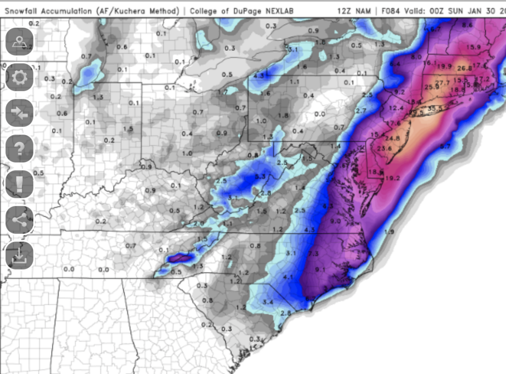

-
2nd run in a row now that has snow with this. Will be interesting to see if the Globals follow.

-
Until I see at least a bit of agreement with the ensembles I am not getting the least bit excited about this. There is not *one* Euro ensemble member with amounts over 3", here the vast majority are no snow or less than an inch. Over a foot, it is to laugh.
-
January 20-22 “bring the mojo” winter storm threat
Cheeznado replied to lilj4425's topic in Southeastern States
This was a very difficult forecast. It can be said that the Euro was a massive bust and the GEFS, while still overdone, was a much better indication that there was a pretty decent chance of it underperforming. -
January 20-22 “bring the mojo” winter storm threat
Cheeznado replied to lilj4425's topic in Southeastern States
DT won't like the 06Z EC and EPS- pretty big change for the worse for many folks. Much more towards the GFS. Yes, the GFS has sucked recently but with this storm it has been pretty consistent having a suppressed system with maybe only a very narrow band of freezing/frozen precip on the northern fringe. This could still change but time is running out. 12Z runs may tell the story. -
January 20-22 “bring the mojo” winter storm threat
Cheeznado replied to lilj4425's topic in Southeastern States
18Z GEFS is mostly a swing and a miss, very suppressed. -
The NAM is almost identical to the GFS so far.
-
EPS father south and a bit stronger as it passes through GA. Snow line a bit farther south. Usually if the 500mb low passes overhead or slightly south we get decent snow and maybe more than decent but for now will stay conservative.
-
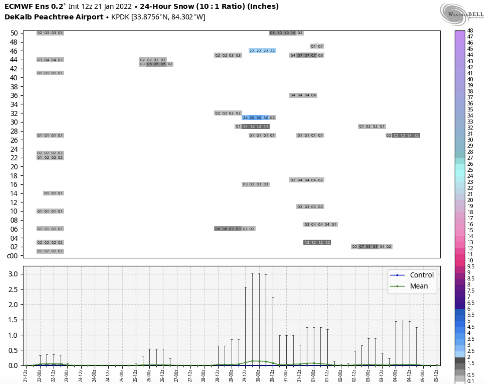
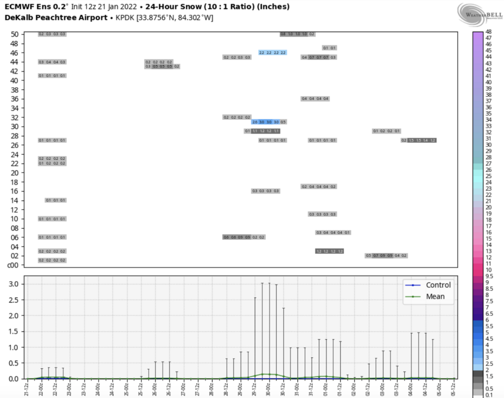
The GEFS members are insane at the airport just north of me (KPDK)- the totals range from 0 to 19!". Just a bit of uncertainty LOL.
-
Yes, but it still trended farther south with the surface low, baby steps.
-
GFS to 57, ULL farther west and more pos tilted. Good trend.