Cheeznado
-
Posts
2,155 -
Joined
-
Last visited
Content Type
Profiles
Blogs
Forums
American Weather
Media Demo
Store
Gallery
Everything posted by Cheeznado
-
Well, there is one GEFS member that has a foot...I agree that the overall pattern might favor some sort of snow event, just do not want to get too excited just yet.

-
No real ensemble support, this is as very likely much a fantasy as the 17" in Augusta that one long range model run had for this last storm.
-
1/10-11 super awesome winter SE OBS thread
Cheeznado replied to strongwxnc's topic in Southeastern States
The 3" of snow this AM was neat, but now the downside- there was .3 or so of ZR afterwards, so recently lost power. 887 separate outages in GA so not expecting it to be restored anytime soon. -
As someone already posted what a massive NAM fail! The GFS and AI Euro did the best here. the ensembles were also very steady on us getting at least an inch, I am just over 2" as the changeover is happening.
-
1/10-11 super awesome winter SE OBS thread
Cheeznado replied to strongwxnc's topic in Southeastern States
Now all sleet. -
1/10-11 super awesome winter SE OBS thread
Cheeznado replied to strongwxnc's topic in Southeastern States
Heavy snow here, approaching 3"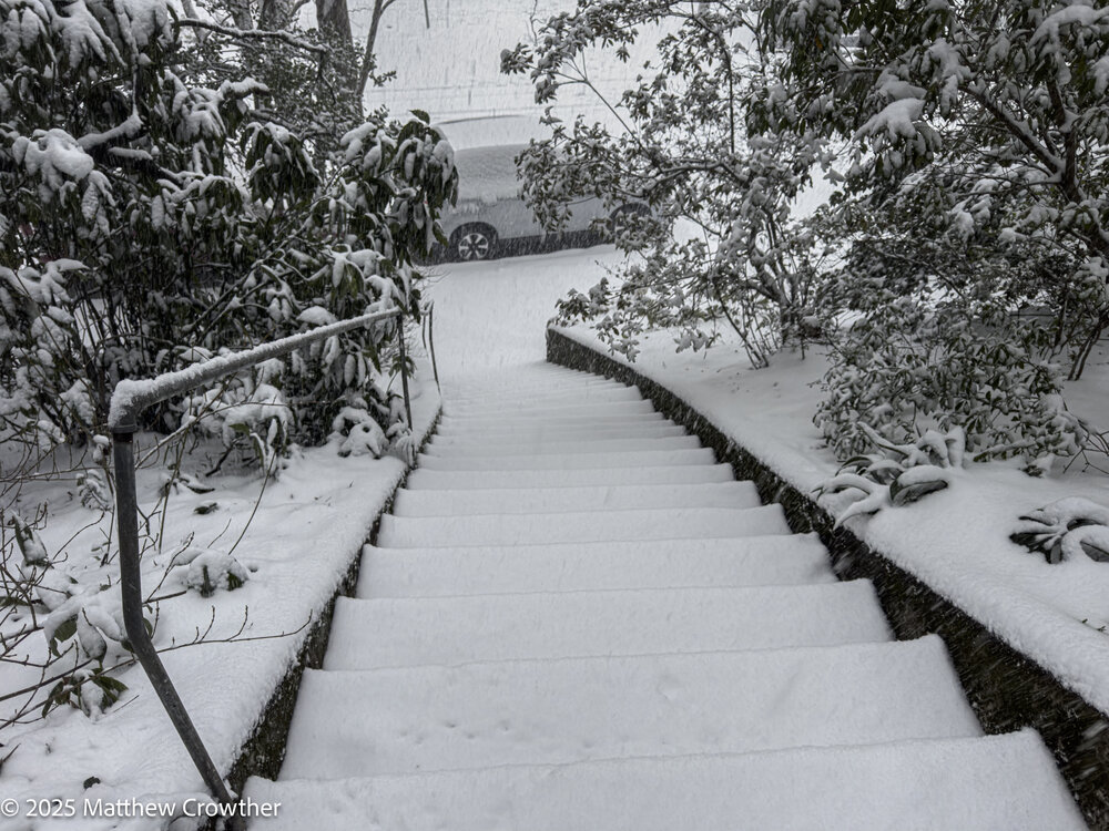
- 510 replies
-
- 13
-

-
Newer runs of the HRRR trending colder with a weaker farther south surface low.
-
0Z HRRR trending warmer, surface low farther north. Not good. EDIT: still gives us 2" of snow/sleet however, Evap cooling doing its work (I hope).
-
GFS colder with more snow here than the NAM, although it still shows a lot of mix.
-
You may be right but still hoping for at least 2" of snow before the changeover.
-
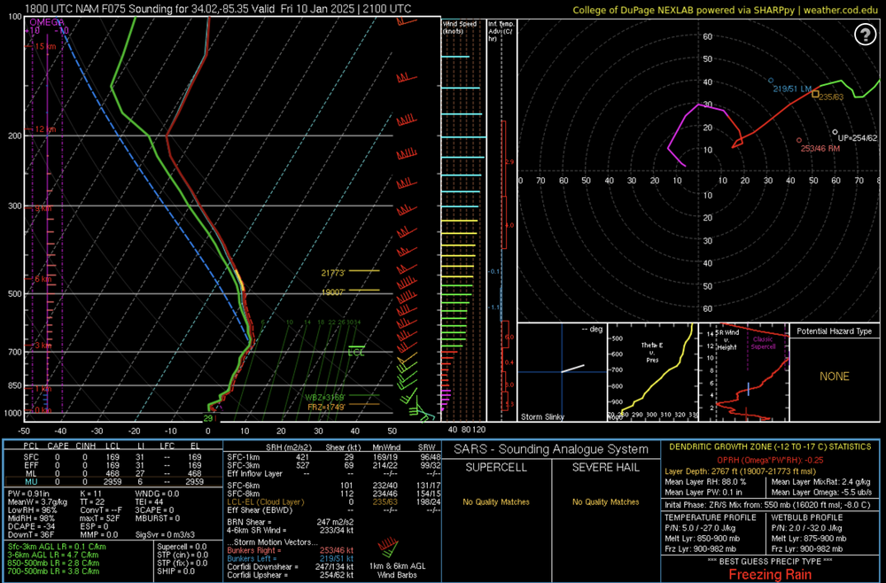
Looked at a NAM sounding near me, not much of a warm nose showing up really so the algorithm may be too icy.
-
Not liking the the new NAM very much. Almost an inch of ZR- yuck. Hope it is bit too warm and maybe we will get more sleet because of evap cooling.
-
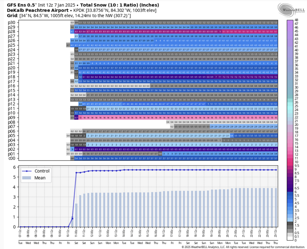
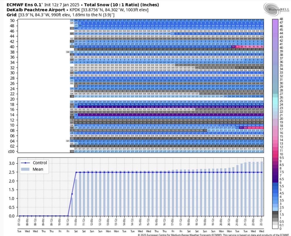
All except a very few ensemble members, both EPS and GEFS have accumulating snow here in Atlanta, consensus is 2-4".
-
Sorry, but this would not be just "decent" for us, it is a dream run which would be the most snow here in quite a few years.
-
Actually this run is better here in GA, the less phased/amped trough keeps the ZR lower, snow line further south.
-
Big changes in the 12Z NAM, Texas and AR folks will not be happy at all, northern stream much stronger, a lot less precip on the northern edge.
-
All frozen here now seems to be almost certain, just hope it stays all or mostly snow and sleet. We have to hope the snow cover up north and evap cooling will help accomplish that. 2-4" of snow mainly north of the Perimiter followed by sleet seems like a reasonable guess.
-
I think that this model does not show ZR/IP
-
The shearing out is a given. The new ICON phases in NM/TX then shears out later. We have to hope for the first closed low to shear out without phasing with the next digging short wave.
-
That was always going to be the case.
-
Models still fluctuating, 12Z GFS utterly different from 06Z with no phase. When you have these wild swings it means we are still in who knows land. I hope once the short wave comes in from the Pacific we will have more clarity, for now just wait and see.
-
Still unlikely that we get a big snow storm here, but the chances for at least over .5 have increased as now the majority of the EPS and GEFS members show at least something. That is a change for the better. We have to root against a strong phase, a sheared out system is a lot better. I have a friend we can stay with up father north if it is a near miss here.
-
Euro much slower with the closed low. Bottom line is that until the short wave that becomes the low actually comes into the US, is it a fruitless exercise to breathlessly post all the different models' solutions which will continue to fluctuate.
-
The models are still vacillating wildly, this still a week out but at least for GA, very few if any ensemble members show a "big dog:" snow any more. Also, the idea of super cold air is also fading fast. Color me very skeptical.
-
It would be very ironic if there is a big dog after the Euro hyped people up a week ago and everyone trashed some for starting up the chatter online. Not saying I believe this certainly but getting more confident we we will at least see some accumulation her in north GA