

TheManWithNoFace
-
Posts
463 -
Joined
Content Type
Profiles
Blogs
Forums
American Weather
Media Demo
Store
Gallery
Everything posted by TheManWithNoFace
-
Much obliged blue
-
@bluewave can you help me out? Please and thank you.
-
Hey everyone I need some help. Many months ago someone posted a chart of annual mean dewpoints at a local observation station over the last several years, if I recall correctly. I need to find that or something similar. Can anyone help?
-
For those defending the public messaging including phone alerts, when did the alarm bells from mets start going off? As it was unfolding? All morning we saw stratiform rain in eastern PA and northern NJ. As soon as the stream of precipitation moved into CNJ and I started seeing widespread embedded cells moving 45° NW to the NE mean flow I knew we were in for it. But I didn't think why transpired was in the realm of likely possibility and I'm fairly plugged in here. People knew Irene and Sandy were coming for days in advance. Dan Zarrow is trying to dance out of it by emphasizing that he was "3 to 6 PLUS" in his forecasting (emphasis on "plus") but come on that doesn't really represent what happened. Phone alerts for flash flooding are all good as it's unfolding but the messaging was inadequate leading up.
-
Is a stronger storm a more compact storm? Does this brief strengthening cut into rain totals across central/southern NJ tonight?
-
Looks like H5 closer or will close off over PA.
-
The 12z euro is 2-5" across the inner and outer coastal plains of NJ tonight if you didn't check.
-
Walt from where do you get the top map?
-
Crops are going to get frosted/frozen in the northern mid atlantic next week. Not good.
-
GFS nailed this storm.
-
OBS and nowcast Thursday morning 2/18 - 11PM Friday 2/19/21
TheManWithNoFace replied to wdrag's topic in New York City Metro
Would love someone to teach me why the entire moisture plume up the east coast looks like its coming from a "forest fire" in the Gulf. https://www.star.nesdis.noaa.gov/GOES/conus_band.php?sat=G16&band=09&length=12 -
OBS and nowcast Thursday morning 2/18 - 11PM Friday 2/19/21
TheManWithNoFace replied to wdrag's topic in New York City Metro
Lol, so casual. "outperforming everyone by several inches, nbd." I have 1.1 in Flemington. Next band crossing the Delaware should deliver the goods. Come to dada -
OBS and nowcast Thursday morning 2/18 - 11PM Friday 2/19/21
TheManWithNoFace replied to wdrag's topic in New York City Metro
Just saw the 6z NAM had none of this in central NJ through 8am. F6 megabust -
OBS and nowcast Thursday morning 2/18 - 11PM Friday 2/19/21
TheManWithNoFace replied to wdrag's topic in New York City Metro
Pingers on moving already on a line straight daddy from Philly. H8 warm tongue gonna getcha -
Feb 18-19 long duration manageable snow and ice event
TheManWithNoFace replied to wdrag's topic in New York City Metro
Radar looks good in PA. Should be arriving in NJ a little early. -
Feb 18-19 long duration manageable snow and ice event
TheManWithNoFace replied to wdrag's topic in New York City Metro
It's too bad WPC ended that model diagnostic discussion product. -
Feb 18-19 long duration manageable snow and ice event
TheManWithNoFace replied to wdrag's topic in New York City Metro
They were bailed out by ratios. -
Feb 18-19 long duration manageable snow and ice event
TheManWithNoFace replied to wdrag's topic in New York City Metro
awww yissssss. Uh, 31 in Flemington rn -
Feb 18-19 long duration manageable snow and ice event
TheManWithNoFace replied to wdrag's topic in New York City Metro
H5 last 8 runs of the nam for 1pm Thursday. Lot's of moving parts in here. Key features are the departing TPV over southern New England, sticking around long enough in later runs to suppress the height field ahead of the approaching shortwave. Then there's the question of whether we get one consolidated vortmax in the trough or if it breaks into two pieces, bringing the longer duration/colder/flatter scenario. Also worth watching is the energy over the northern Plains and how it wants to interact in trough. SE ridge modelling looks stable here. Snow to sleet to rain for most of NJ, but could easily trend back to the warmer solutions of a couple days ago or a more compressed height field and a harder thump. Lots of moving parts. H5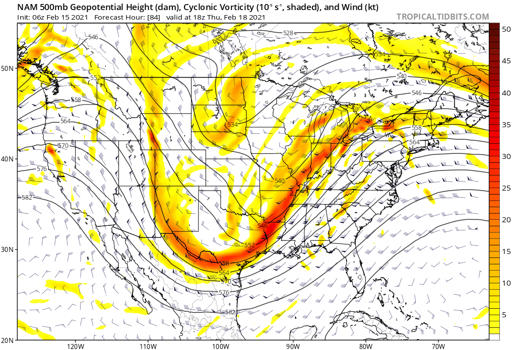
-
2-7-21 Sunday 8-12 hour nor'easter snowstorm roughly 5A-5P
TheManWithNoFace replied to wdrag's topic in New York City Metro
Could you tell me where you find this product? -
Very strange. For a couple hours it was sleeting in Flemington, Nj while snowing in Philly.
-
Flflemington130pm straight sleet homey
-
Waddup neighbor! I think that makes.at least 5 of us in.Hunterdon and Somerset.
-
Wow the Hunterdon/Somerset corridor is well represented here. 5" in Flemington.
- 1,932 replies
-
- 2
-

-
- heavy snow
- wind damage
- (and 1 more)

