nj2va
-
Posts
14,446 -
Joined
-
Last visited
Content Type
Profiles
Blogs
Forums
American Weather
Media Demo
Store
Gallery
Everything posted by nj2va
-
Follow your user name and head just NW of the fall line.
-
There’s too many models.
-
Hit freezing 32.0/20
-
That’s a sweet sounding
-
It’s chips fall time. 4-7” seems locked in for DC/NVA.
-
Impressed by the temp drop. 32.7/21.
-
34.3/19
-
We’re pretty locked and loaded for a great 4-7” event.
-
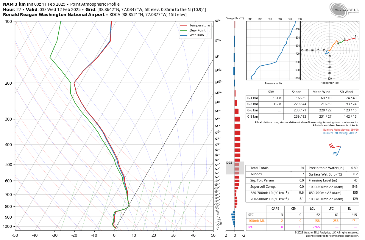
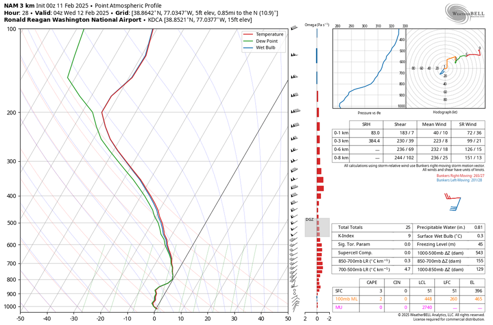
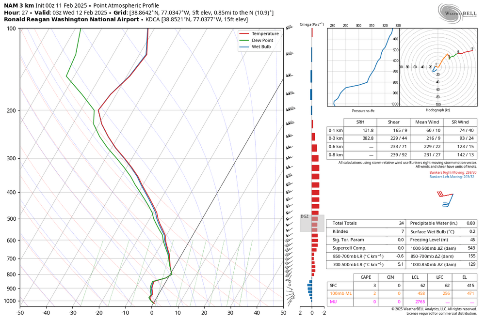
I know the precip type output shows sleet on WxBell but sounding looks like we just hold onto snow at DCA. ETA: I realized I added 11p. The 10p sounding does show a warm nose briefly so would mix with some sleet verbatim briefly.
-
It shows 2” with 1.3” snow depth change by 4p. I’d wager the under on that in DC/inner burbs. I think we’re probably not accumulating on paved surfaces until closer to sunset. Still, a fantastic run for the area.
-
3K gets DC up to 37 tomorrow but drops to freezing/below by 3p.
-
WOOF
-
Relatively speaking that was a “disaster” and DC still gets 3.5”…not bad!
-
36.1/19.
-
It’ll be white rain until sunset in the city, just prepare yourself for that.
-
38/21. Feels like snow.
-
Yeah warnings up to EZF. I would expect in the afternoon update, NVA/DC/etc are included.
-
I just want to max my bet winnings at this point
-
Terrible halftime show and a boring game.
-
I think a 3-5”/4-6” deal for DC/nearby burbs would be my call as of now.
-
Heading into Tuesday, we have a favorable setup for a long duration of snow across the area. With a broad upper trough over the CONUS and a CAD wedge over the area with surface high pressure to our northeast, we`ll have a cold thermal profile in place and Gulf moisture streaming in aloft from the SW Tuesday and through midweek. Confidence is increasing for an enhanced winter storm threat for the entire area. Precip is expected to begin in our southwest late Monday night into Tuesday morning and overspread the area SW to NE through Tuesday and continue into Wednesday. Precip type is expected to be snow for most of the area, with some sleet/freezing rain possibly mixing in along our southern tier where warmer air aloft will intrude in. High temperatures top out in the mid 30s. Current expected snow total is a widespread 3-5 inches between Monday night and Tuesday night, with locally higher amounts to around 6 inches possible. The entire event isn`t captured fully by the next 72 hours, so check weather.gov/lwx/winter for the latest as we grow closer.
-
UK looks better to me. 8” in DC, 6” up towards Balt. 11” in the Northern Neck. 10:1 maps.
-
Got up to 43 but temp dropping and winds have flipped out of the NW. Down to 41/41.
-
If it means that southern PA will get 4” while DC gets 8” then so be it. Imby sport.