

nj2va
-
Posts
14,481 -
Joined
-
Last visited
Content Type
Profiles
Blogs
Forums
American Weather
Media Demo
Store
Gallery
Posts posted by nj2va
-
-
Just now, NorthArlington101 said:
Go kill them tomorrow/Monday. Will pop in to look at some pics and share any good ones/obs I get from my girlfriends and dedicated network of snow spotters.
Players gonna play. How many do you have?
-
 3
3
-
-
1 minute ago, stormtracker said:
Yeah, I'm waiting. It does seem a touch cooler tho. Can't for sure say a south trend yet
Definitely cooler for dc. Mod/heavy snow at 12z Monday on 00z run vs sleet on 18z.
-
 1
1
-
-
3 minutes ago, WxUSAF said:
Ah interesting. Nice catch.
It looks like in the last radar frame, the snow line pushed south to the KC airport.
-
Just now, Deck Pic said:
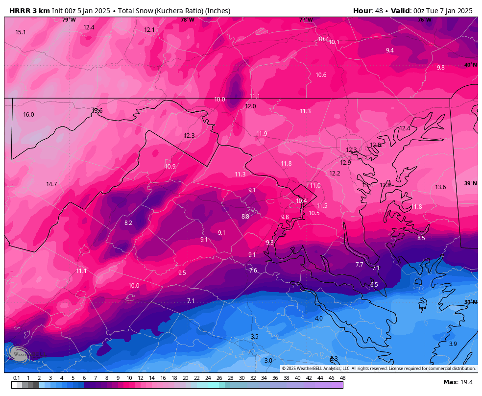
This is sim radar at hour 48 when the HRRR truncates. Hard to say how much more. Could easily be another 1-2"

Sick

-
3
-
 1
1
-
 1
1
-
-
Back building happening as the coastal gets going.
-
3 minutes ago, clskinsfan said:
Hit the wall and coming east now. Plenty cold EZF and north.
What a gorgeous run. No mixing issues even close to DC. EZF flirts for a bit but what a beatdown in the region.
-
2
-
-
1 minute ago, pazzo83 said:
Ovi with 4 goals in his first 5 games back. Dude wants it.
If this pace continues, I need to start figuring out possible games to get tickets to. If (when) he breaks the record, I want to see it.
-
2
-
-
Just now, clskinsfan said:
Caps are killing it right now.
Their locker room has that vibe to it that can get them far in the playoffs.
-
3
-
-
Oh and suck it Rangers. Caps won and Ovi scored again.
-
5
-
-
25 minutes ago, TSSN+ said:
Don’t see much of a change there at all.
A slight drop in totals in S NJ/S PA and the 6” contour expanding southward in VA.
-
1
-
-
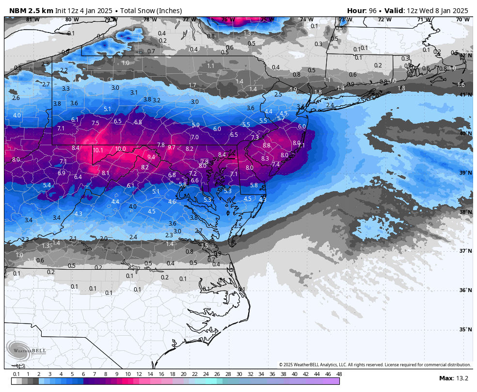
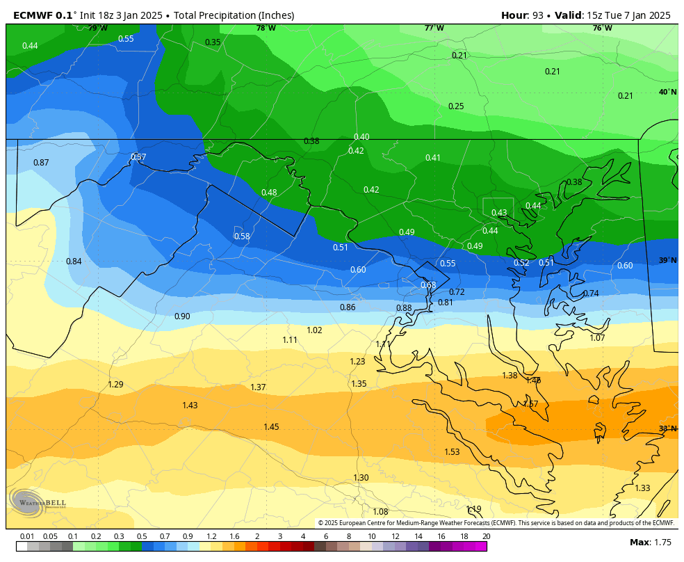
Last four runs of the NBM. 6” line continuing to tick south towards EZF.

-
6
-
1
-
-
12 minutes ago, Deck Pic said:
EDIT = it's fine. I'm tired. I was looking at 12z.
that was a sick run (again) for us. Cold smoke.
-
4
-
1
-
-
16 minutes ago, WxUSAF said:
If anyone has a gif of euro total precip from last 3-4 runs, I’d appreciate it!

-
6
-
 3
3
-
1
-
-
Something to pay attention to within 24 hours on the meso models is the potential for the dual banding to set up…one south and another north like many Mets here have talked about.
GFS sort of shows this happening here.

-
2
-
-
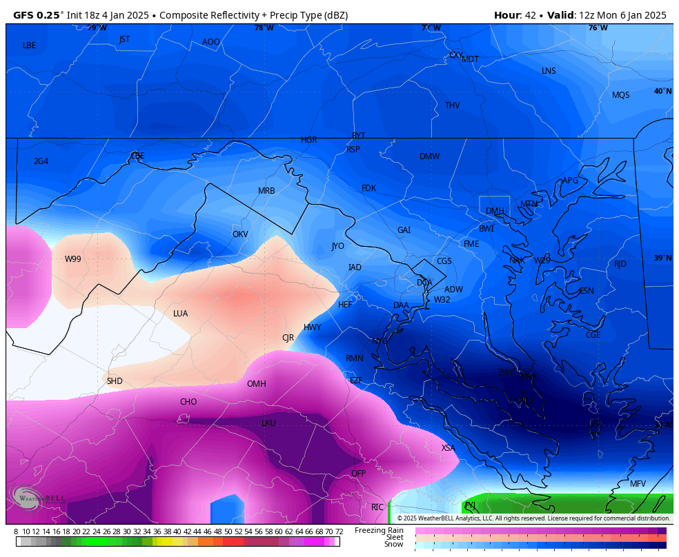
Pivotal has snow breaking out in DC at 3z Monday.
-
3
-
-
Just now, wawarriors4 said:

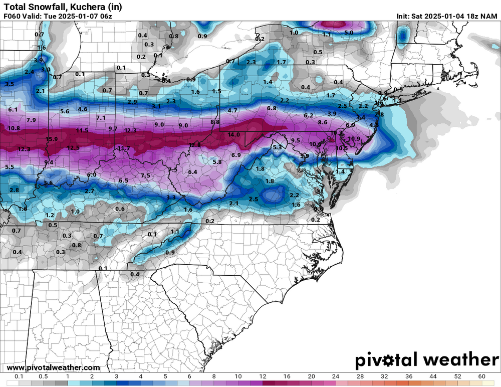
Wow, what a hole! Around Fredericksburg, this is my favorite map ever……
30 or so hours from onset and EZF gets anywhere from a dusting to over a foot of snow. Wild.
-
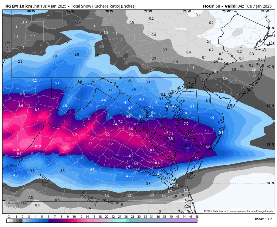
Crazy how solutions are still diverging. RGEM heads south. A really great run for EZF.
-
4
-
1
-
-
I don’t think RGEM is budging from favoring CVA (near EZF) with the heaviest rates.
ETA: Looks like its cutting totals to the north (M/D) and upping totals in the south (RIC).
-
1
-
-
This system is definitely dynamic. Blizzard warnings added out in Kansas.
-
5
-
 3
3
-
 1
1
-
-
It wouldn’t be a mid-atl storm if the northern peeps weren’t panicked.
-
2
-
-
Very cool stuff!
-
1
-
 2
2
-
-
Giggidy, giggidy. Zoomed in to the DC area.
-
10
-
-
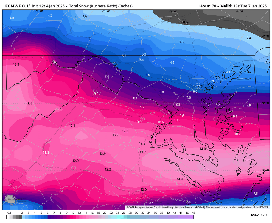
UK and GFS comparison at H51 below. Our SW is a bit further south on the UK but look up north. UK has a closed low vs open wave on the GFS. I think that’s impacting it but I’m stoopid so what do I know.

-
5
-
-
Now that we’re under 48 hours, the ‘north trend’ certainly hasn’t popped up so far.
-
4
-


January Banter 2025
in Mid Atlantic
Posted