nj2va
-
Posts
15,351 -
Joined
-
Last visited
Content Type
Profiles
Blogs
Forums
American Weather
Media Demo
Store
Gallery
Everything posted by nj2va
-
I seriously hate that team
-
Oh damn, I had to sell my seats tonight as I was stuck at the office late…would have been cool to say hi! Since they lost, you’re not allowed at another game
-
Totally, especially that 4 or 5 minute stretch where they gave up 3 goals. Oof.
-
Man, they were pouring it on there the last 5 minutes. Sharks goalie just had incredible saves.
-
Oh yeah, Willy is my #1
-
I want to marry him
-
That was rough
-
Finally! @pazzo83 https://wtop.com/washington-nationals/2026/01/the-washington-nationals-are-finally-leaving-masn-and-setting-up-a-local-tv-deal-with-mlb/
-
Awesome, poor @aldie 22, he may need to move for the 50th time
-
Wow
-
Nice moisture in the Gulf
-
That stuff down in the Gulf area in LA/TX looks good
-
Woo!

-
Will also +1 @katabatic - we met up for dinner in Deep Creek a few winters back…great guy and has a genuine love of weather. Enjoy the chase NA101!
-
It was like I watched two different teams for periods 1/2 and period 3 tonight.
-
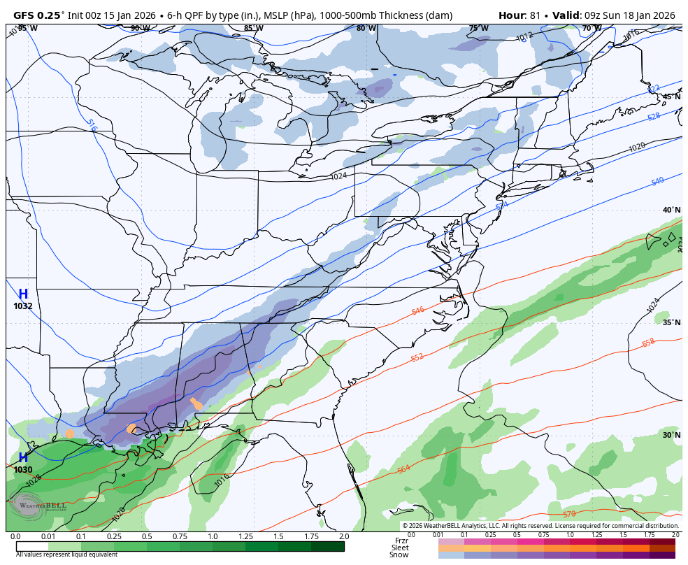
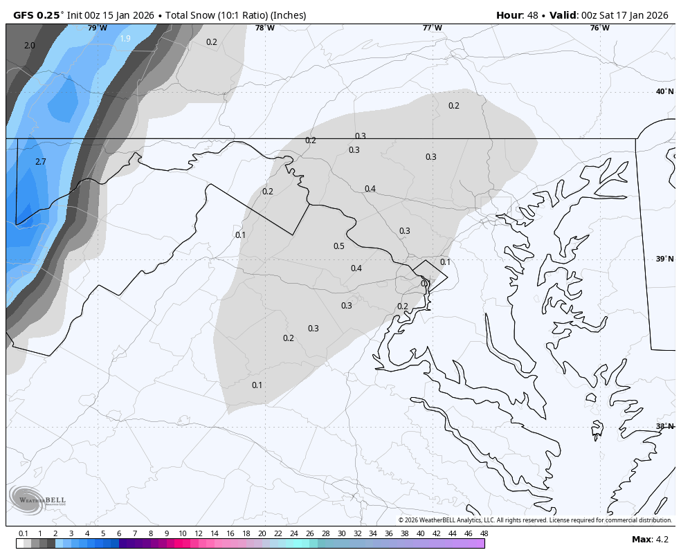
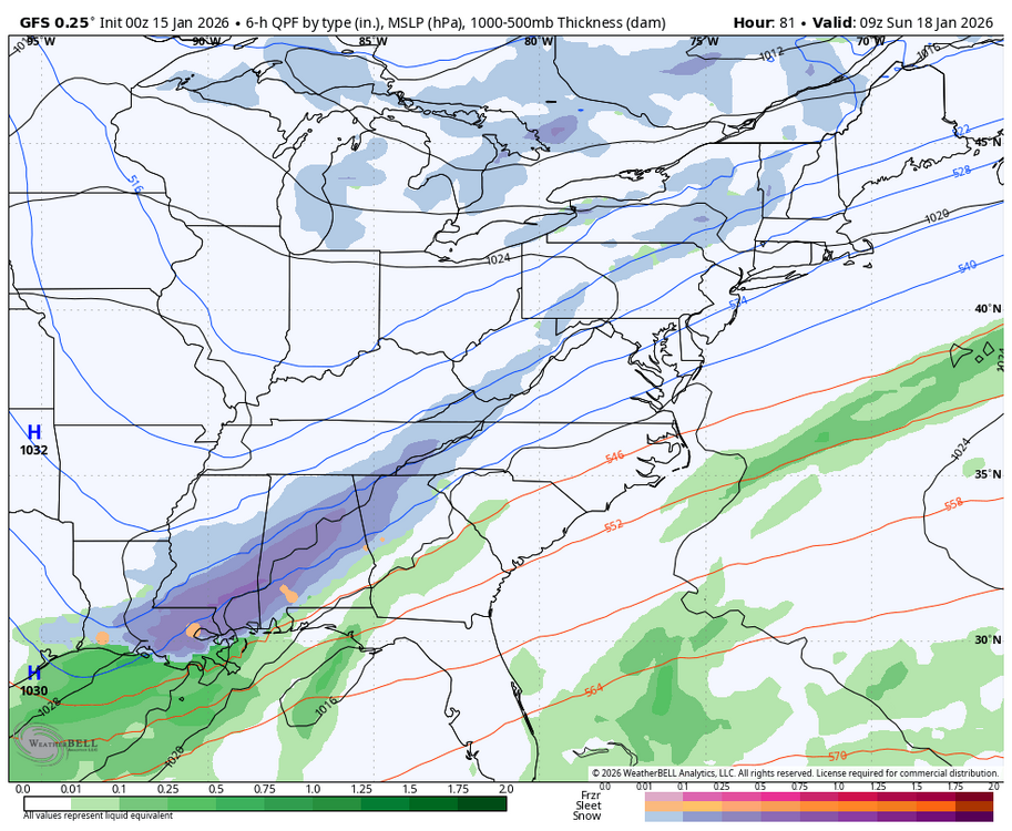
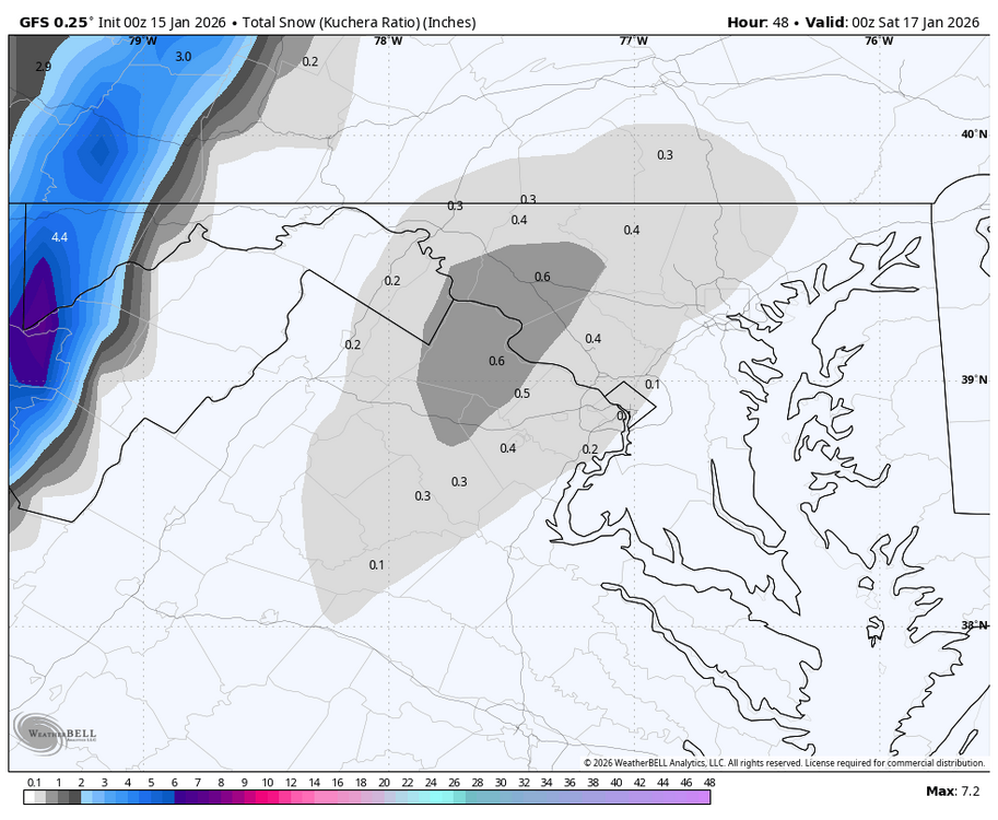
Good summary for you by LWX - snipped the portion about Friday into Saturday: KEY MESSAGE 3...A low pressure system may bring snow to the Allegheny Mountains Friday through Saturday night. One, possibly two low pressure centers will meander through the Great Lakes Friday into Saturday as a series of shortwave troughs result in amplifying long wave troughing into the eastern US. There may be some light snow showers along the Allegheny Mountains on Friday, but the higher chances will arrive Friday night through Saturday night as the main trough approaches. Temperatures may attempt to rise above freezing Saturday in some of the valleys before the cold front pushes through, but profiles will be cold enough for all snow for most locations along and west of the Allegheny Front. Accumulations resulting in travel disruptions are possible. To the east of the Alleghenies, there are mixed signals whether any precipitation falls, but it will be related to the push of warm advection Saturday morning and/or the cold frontal passage Saturday afternoon/evening. Some snow or a mix could occur depending on the timing of any precipitation, but at the moment, impacts appear limited at the lower elevations. For temperatures, Saturday is expected to be the warmest day of the weekend before the cold front pushes through.
-
See ya there! Going up to the house Friday - Monday. Good call, it’ll give you a snow fix ahead of our epic SWFE
-
Great comeback win by the Caps!
-
Sorry man, at least its more time for you to track all of our HECS
-
Texans are gonna be tough for the Pats…esp if Stroud can learn how to play football again
-
Is that 4 fumbles (2 lost) and 1 INT by Stroud tonight? Yeesh
-
NFL saved the worst game for last
-
Chargers blew that game, should have been 14-3 early. I thought the Patriots looked beatable…Houston (if they win) will be a tough matchup. I still think the winner of the DEN/BUF game are favorites to reach the SB for the AFC.
-
It’s a great day when the Eagles lose
-
Man, another WC game coming down to the last possession. What a great weekend of football