nj2va
-
Posts
13,695 -
Joined
-
Last visited
Content Type
Profiles
Blogs
Forums
American Weather
Media Demo
Store
Gallery
Everything posted by nj2va
-
I was drinking my coffee and scrolling through and thinking “wow, maybe it’ll be a positive day in here” after seeing CAPE’s comments. Then I got to the “unmitigated disaster” part and laughed.
-
It was sad just watching the last new Jeopardy episode that Alex Trebek taped as the host. What a legend he was. RIP.
-
If you didn’t live there, I’d be pissed that your area was getting more snow than DC. Enjoy the storm!
-
GEFS says temper your expectations for snow through the next 9-10 days outside the mountains. While a threat could pop up in the short/medium range and/or next week trends back into a minor event, today’s guidance has been pointing to the more favorable period many here have talked about for increased snow chances. It sucks, but it is what it is. If the strong ULL works out over MLK weekend, I’d suggest people chase to the mountains of MD/WV and get your dose of snow. Good for the psyche.
-
It would be best for some on here's mental health if they just step away from the LR thread for the next 8 days. I imagine its going to get ugly (or -ier) in there, fast.
-
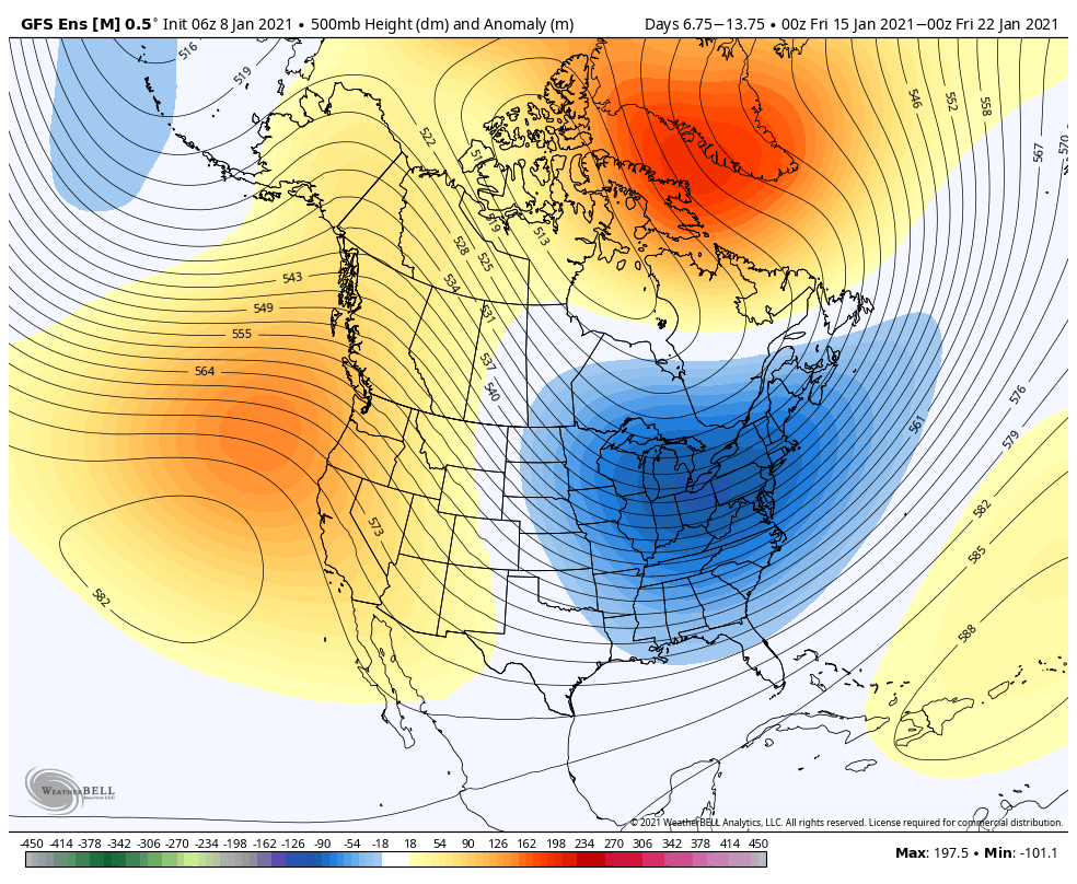
The only thing about that 500 map that I missed picking up on from the 6z version is I wonder if that suggests a Miller B pattern given the deepest 500 anomalies are centered north of our latitude. @CAPE - would we want those focused a bit further south?
-
If you like SE snow, GFS says 'look at me D12!'
-
at times a whole page of a thread is just quotes of long posts and images, lol
-
We often score when the NAO relaxes.
-
The heck if I know....the smarter ones could comment way better I'm sure. A few thoughts I have: 1) The H5 pattern gets exponentially better for snow chances in the region beginning in a week or so. If it happens verbatim, it would take an epic fail for MA standards to not see snow (people should temper their KU expectations since those are hard to come by). 2) You're beginning to see signs on the GEFS snow mean maps that the period beginning in a week or so has some legs if you compare that to what we usually see for a 5-7 day snow mean. While I don't live and die by snow mean maps, they're helpful in spotting uber LR trends in potential. Yeah, I'm sure its the weenie in me saying this but I find it hard to believe we are shutout the rest of the month.
-
6z GEFS isn’t enthused on snow chances for the next 7-8 days. Continues to suggest our chances increase after the 15th/16th. ETA: Here’s the 7 day mean ending 1/22. if we can’t score a warning-level event in this pattern along 95, time to see PSU and Ji go scorched earth.

-
I haven’t looked at the surface at all but 500 is north of 18z and heights are a good bit higher along the coast. Hopefully translates to the surface... ETA: No dice.
-
Vort on the GFS looks good through 84 but we need that confluence shred factory to lift north to hold it together in the next couple frames. Heights are a touch higher than 18z along the coast. Let’s see what happens from here.
-
Looks better at H5 than 18z GFS at H90. What could go wrong?
-
Weeklies are useless Week 3 and beyond but I’d argue they’re useless every week....
-
We’ll be talking about the epic MLK day blizzard with that pattern.
-
I’m not a fan of living and dying by snowfall mean maps BUT 18z GEFS 5 day snowfall mean (1/16-1/21) is 2” in DC. That’s as good a signal we could expect 10-14 days out for a 5 day mean.
-
@mdhokie - second day in a row a GFS run gave 3-4 feet for Deep Creek through 1/23.
-
If GFS ran to 400 hours, Ji would have been happy with more blue over him.
-
I thought WxUSAF hit on this earlier today in the model thread....weak west coast ridging so I think it means there's a lot of s/w flying all over. I'm a dummy with weather so who knows if this is right but perhaps that changes when we get better WC ridging later this month.
-
Bullseye of 9" of snow on the LA/MS border.
-
"I had a feeling things weren't going to trend well in the pattern change, but I was afraid to say it."
-
Can you clarify what makes the upcoming pattern a bootleg NAO ridge vs a true H5 block?
-
I was thinking something along similar lines but you articulate it way better - I like your idea of some kind of atmospheric/H5/pattern and a separate S/MR threat thread. When we had the December threat, this was getting a bit much in here between tracking H5 patterns and the actual threat IMO.
-
@frd all of that is fine and interesting, but I’m over tracking wind changes and pattern changes, and ready to track a threat.