nj2va
-
Posts
13,695 -
Joined
-
Last visited
Content Type
Profiles
Blogs
Forums
American Weather
Media Demo
Store
Gallery
Everything posted by nj2va
-
Euro control is a great hit too. Coastal forms over Nags Head to just east of ORF, stalls for a bit, and heads ENE from there. CCB cranks over the area.
-
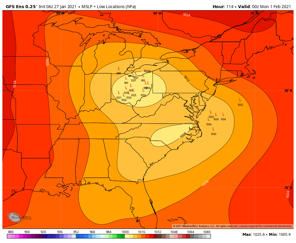
I count 32 EPS members that give DC 6"+ of snow. And 50/50 gets at least 2" into DC. Sweet.
-
Love seeing the 500 low closed on the EPS...shows the amount of agreement on a sweet 5H track. Also, has a double closed 500 low by 144 just off OC.
-
It doesn’t seem like suppression is even on the table given we’re now under 100 hours out.
-
Agreed, I’d be fine if we got that (in MBY) - anything on top of that is gravy.
-

January Storm Term Threat Discussions (Day 3 - Day 7)
nj2va replied to WxUSAF's topic in Mid Atlantic
Sounds like its time to move then. Welcome to climo. -
January Storm Term Threat Discussions (Day 3 - Day 7)
nj2va replied to WxUSAF's topic in Mid Atlantic
So far through 132, its all snow for the cities and points just east IMO. -
Totally agree. Unrealistic expectations were established yesterday IMO. And now anything less than a foot is a "disaster".
-
I just caught up on the "analysis" in the main thread....that was impossible to follow.
-
January Storm Term Threat Discussions (Day 3 - Day 7)
nj2va replied to WxUSAF's topic in Mid Atlantic
It screamed textbook setup for the MA to me at 500 but what the hell do I know. -
Clearly I need to learn my geography....I always assumed you were in SE VA lol. I thought I passed a Salem, VA en route to OBX every summer....oops
-
January Storm Term Threat Discussions (Day 3 - Day 7)
nj2va replied to WxUSAF's topic in Mid Atlantic
LWX bumped the entire area into “Enhanced” on Day 5. And here’s their latest disco: .LONG TERM /SATURDAY THROUGH TUESDAY/... High pressure overhead will keep us dry and chilly Saturday. As the northern fringe of this high departs toward the northeast, the southern half will wedge along the eastern slopes of the Appalachians. This will likely keep cold air in place ahead of a developing low pressure system that could bring us a mix of rain and snow or all snow later in the weekend. Clouds will increase Saturday night before thickening with precipitation arriving Sunday. As of now, the precipitation looks to arrive as some light snow late Saturday night into early Sunday from southwest to northeast. As an easterly flow increases ahead of the main storm system, we throw a factor of rain into the precipitation type mixture. By late Sunday evening and continuing Sunday night and through midday Monday, the easterly flow gradually becomes more northerly. This is due to a coastal low pressure system forming near the Outer Banks and intensifying as it moves toward the northeast. By Monday night and into Tuesday, precipitation should taper off and end slowly from west to east as the coastal low moves away and high pressure becomes reestablished in the region. Temperatures will be near average during the lifetime of the storm system. -
January Storm Term Threat Discussions (Day 3 - Day 7)
nj2va replied to WxUSAF's topic in Mid Atlantic
6z GEFS seems to have a quicker transfer and there are some SLP ensemble plots showing up off the coast in a better location. It also gets the northern part of the subforum in on the coastal as it redevelops. But its still night/day from the EPS with the evolution.
-
January Storm Term Threat Discussions (Day 3 - Day 7)
nj2va replied to WxUSAF's topic in Mid Atlantic
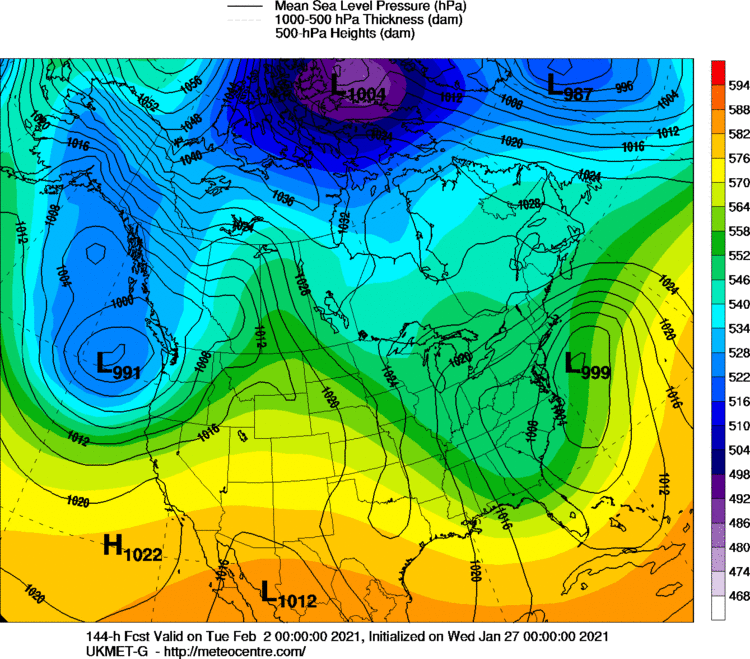
Here’s UK at 120 and 144: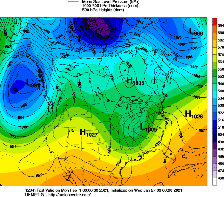
-
January Storm Term Threat Discussions (Day 3 - Day 7)
nj2va replied to WxUSAF's topic in Mid Atlantic
No one cares what happens north of the forum, sorry. -
January Storm Term Threat Discussions (Day 3 - Day 7)
nj2va replied to WxUSAF's topic in Mid Atlantic
Dude, get your expectations in check. Euro is on an island with that extreme solution right now. Set yourself for a 3-6” event and enjoy if there’s an upside. -
January Storm Term Threat Discussions (Day 3 - Day 7)
nj2va replied to WxUSAF's topic in Mid Atlantic
Neige! -
January Storm Term Threat Discussions (Day 3 - Day 7)
nj2va replied to WxUSAF's topic in Mid Atlantic
It’s hard to argue against the EPS 500 evolution...such a huge signal for an amplifying SW. Also, GFS has been.....wait for it.......trending. -
January Storm Term Threat Discussions (Day 3 - Day 7)
nj2va replied to WxUSAF's topic in Mid Atlantic
Looking at the crayon GGEM maps, 1007 LP in KY at 120. 999 off Cape May at 144. -
January Storm Term Threat Discussions (Day 3 - Day 7)
nj2va replied to WxUSAF's topic in Mid Atlantic
Amazing how different the evolution at 500 is than the Euro. Vort on the GFS is robust/closed over the plains but then opens/weakens as it heads east. Euro has a much stronger vort. -
January Storm Term Threat Discussions (Day 3 - Day 7)
nj2va replied to WxUSAF's topic in Mid Atlantic
GFS has light snow breaking out in the SW part of the forum late Saturday night. -
January Storm Term Threat Discussions (Day 3 - Day 7)
nj2va replied to WxUSAF's topic in Mid Atlantic
PSU panics about being fringed and an hour later ICON jackpots him with 1.5” QPF as snow. -
January Storm Term Threat Discussions (Day 3 - Day 7)
nj2va replied to WxUSAF's topic in Mid Atlantic
Precip is in the SW part of the forum late Saturday night and into DC after midnight. yes, its always good to be measured around here but this isn’t a week out. Ninja’d by losetoa6 -
January Storm Term Threat Discussions (Day 3 - Day 7)
nj2va replied to WxUSAF's topic in Mid Atlantic
Closed 500 ensemble mean again. Wooooooooof. -
January Storm Term Threat Discussions (Day 3 - Day 7)
nj2va replied to WxUSAF's topic in Mid Atlantic
BTW, looking at the Euro our vort is onshore within 72 hours.