

nj2va
-
Posts
13,695 -
Joined
-
Last visited
Content Type
Profiles
Blogs
Forums
American Weather
Media Demo
Store
Gallery
Everything posted by nj2va
-
I’d say. 0.5” runs through DC by 4p tomorrow.
-
The guy lives in ME so take it with a grain of salt.
-
This has been my philosophy too. If I get 5” tomorrow from the WAA, I’d be happy. CCB is a bonus.
-
It’d be an epic fail even for DC standards if we don’t get 5” Sunday - Monday. I’m more interested in the WAA. CCB will be so tricky to nail down.
-
As Deck Pic pointed out, this is really spread out. I’m putting all my eggs in the WAA which was about 3-5” in DC. Sunday will look pretty.
-
Agrees with the cutback in WAA which I don’t want to see.
-
Euro rolling. Fully expect 2 feet for PSU/north. I’m good with a warning event here.
-
Such a great movie
-
I’m watching the The Net right now with Sandra Bullock. Throwback movie and such a good, underrated movie. “Just give us the disk Angela, and we’ll give you your life back.”
-
God save the queen! Although some people swear by the UK, I never think its a good model lol
-
South, south, south!
-
Your backyard is seeing favorable trends with the coastal. DC/NOVA isn’t, at least with the 00z suite so far except the CMC which just got NOVA into the coastal. The initial slug of moisture from the WAA going south isn’t necessarily indicative of the coastal deepening in a great location for NOVA on north...they are two separate things. That is more dependent on the orientation of the trough, strength of 500 low, etc. At least I think.
-
Holy hell for some random poster in PA or for us too?
-
Yup, same for me. Give me like 0.5-0.6” QPF as snow Sunday and I could give two Fs what happens with the coastal. Miller Bs hate DC and the trends 00z show why. And eeeeeek, I just realized you’re a Flyers fan (makes sense with the profile picture!). You just lost a few points for me.
-
There’s a scenario where you actually do better than up here IMO. WAA targets Central VA and CCB targets north of Baltimore.
-
Not the trend I like to see continue on the 00z suite. Hopefully that reverses tomorrow as the mesos get into range.
-
Do you think we need to post 15x/page in the storm thread about worrying over the north trend for the opposite to happen?
-
Yeah, I’ve always been more interested in banking on WAA since thats the “easy” stuff. Coastal/CCB is fun but if you’re relying on the CCB to get a lot of snow at DC’s latitude in a Miller B/hybrid, you’re setting yourself up for failure. A worst case for DC would be 1-3” WAA and 1-2” from the coastal. Not terrible given DC’s lack of snow recently but would be a kick in the you know what.
-
I’m shocked. GFS also shifting WAA south a bit; not a fan of that for MBY. DC needs to cash in on the WAA since the CCB looks to stay north.
-
He panicked his way into 2 feet on the RGEM.
-
To be expected, its better north. That seems to be the place to be as the low deepens.
-
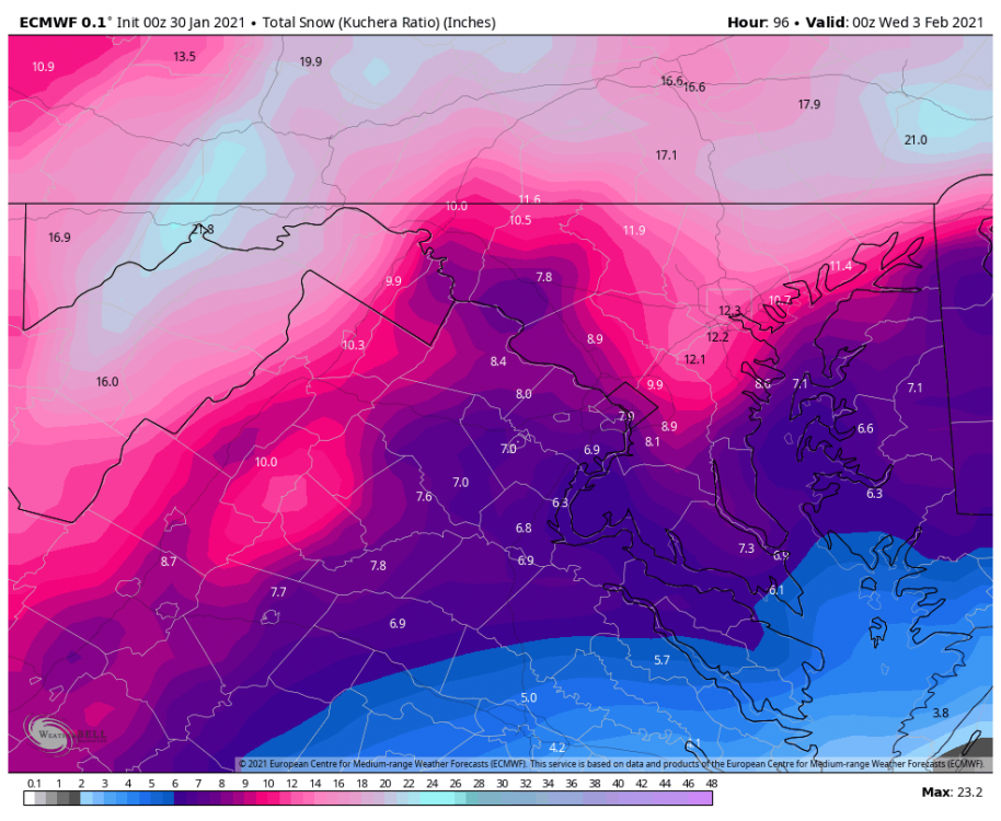
Yep, we’ll likely mix at some point but if we get 4-6” from the WAA and 1-3/2-4 from the coastal, that’s basically 75% of our climo in one storm, ha. I’m excited.
-
Much better run for DC. Doubled the snowfall from 12z. It’s the rare region wide storm that gets RIC all the way to the M/D line.
-
They expanded back to Garrett County (now covered by LWX instead of PIT).
-
Better WAA so far at least for DC through 7p Sunday. 5” OTG vs 3” at 12z. EZF almost 8” by 7p Sunday.


