nj2va
-
Posts
13,695 -
Joined
-
Last visited
Content Type
Profiles
Blogs
Forums
American Weather
Media Demo
Store
Gallery
Everything posted by nj2va
-
“Somewhere out are four terrible fathers I wish I could thank for this” Such a great movie
-
A glass of Sauvignon blanc. We fancy in South Arlington.
-
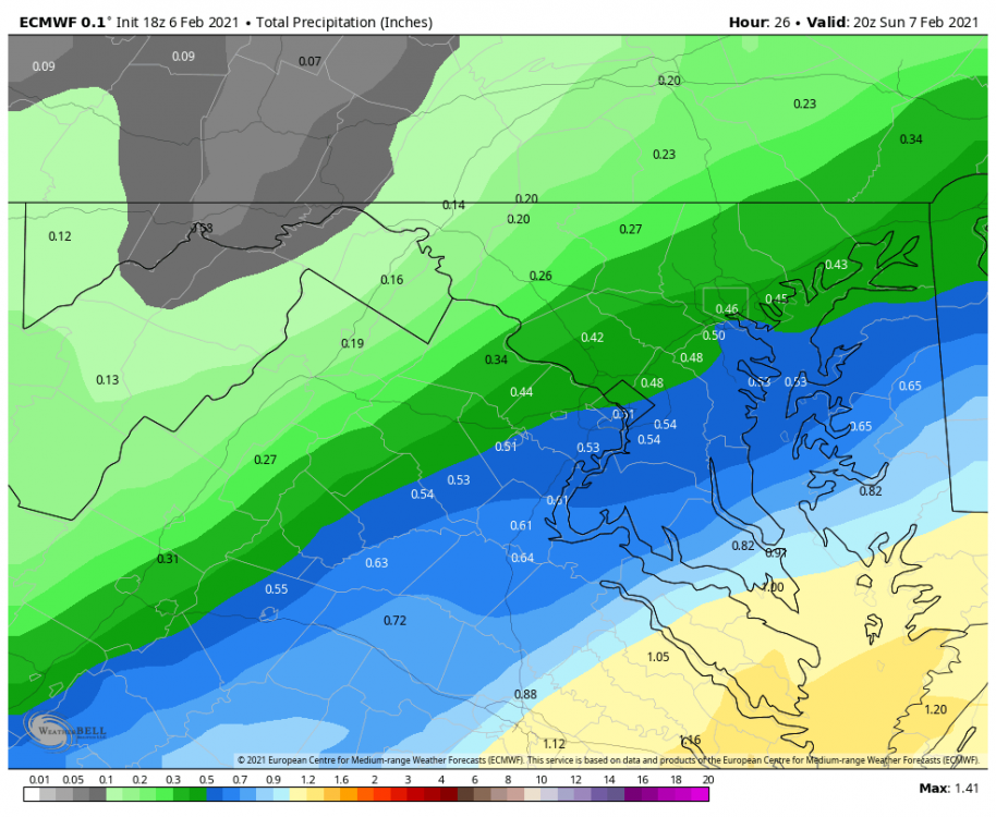
Here’s a higher resolution view of QPF distribution. As CAPE said, slight SE shift but not huge.
-
45/26.
-

Feb Long Range Discussion (Day 3 and beyond) - MERGED
nj2va replied to WinterWxLuvr's topic in Mid Atlantic
55” for Deep Creek. -
49/23. I picked a good day to not read this thread apparently.
-
6z Euro

-
There’s too many models thesedays.
-
She puts on a great concert. Almost as good when you post the 700 fronto maps that nail DC.
-
She was legit amazed that we post on a weather forum together...I swear she was star struck.
-
I’m so used to seeing your posts in here asking for the latest EPS, GEFS, etc QPF maps, I was shocked you had a joke to post.
-
I think he’s kidding.
-
I was on a Zoom call at work today - we got talking about the weather and one of the partners I work with said “Do you follow Jay’s Wintry Mix on Facebook? It’s where I get all my weather info from. He’s really funny and usually right...” @Ji @leesburg 04
-
Check out the wind chill warning for ND....wow WIND CHILL WARNING IN EFFECT FROM 6 PM THIS EVENING TO NOON CST TUESDAY... * WHAT...Dangerously cold wind chills expected. Wind chills as low as 50 below zero. * WHERE...Portions of north central and northwest Minnesota and northeast and southeast North Dakota.
-
Absolutely beautiful. Totally fine with a day like today.
-
Meanwhile DCA will probably be 22 at the height of the cold.
-
Good disco by LWX: .SHORT TERM /SATURDAY NIGHT THROUGH SUNDAY NIGHT/... The coveted shortwave trough responsible for the rather dramatic shifts in the forecast for the second half of the weekend moved onshore of western North America overnight, and is expected to be amplify over the Tennessee River Valley Saturday night. This will result in cyclogenesis (development of low pressure) off the southeast coast. It appears the northwestward trend in the track of this low pressure closer to the coast is due at least in part to (1) a slightly stronger ridge over the southwestern Atlantic Ocean deflecting the low pressure closer to the coast, and (2) slightly more separation and amplification between the incoming shortwave trough, and low pressure associated with today`s cold front departing over southeastern Canada; this results in a subtle yet all-important opportunity for phasing between the northern and southern branches of the jet stream. What this means in terms of sensible weather locally is that the chances for precipitation have increased markedly for Saturday night into Sunday. The airmass will be marginally cold (see: high temperatures near 50 the preceding day on Saturday), but should be cold enough for the bulk of the precipitation to fall as snow (though a start as light rain or a mix is possible). The late- night timing of precipitation and dynamic cooling aloft from lift between the phasing shortwave troughs on the northwest side of the surface low should keep temperatures cold enough for (wet) snow during the height of the event, and the dynamics may result in a few bands of moderately heavy snow at times, particularly SE of US-29. The potential for a warning-level snowfall event (5"+ in 12 hours east of the Appalachian Mountains) seems modest despite the dynamics given the marginal temperatures and the short duration of the event. Still, any further shifts may result in an uptick (or downtick) in forecasted snowfall amounts.
-
Feb Long Range Discussion (Day 3 and beyond) - MERGED
nj2va replied to WinterWxLuvr's topic in Mid Atlantic
Nice moisture feed at H144 pointed directly at the area. Busy tracking ahead. -
NSFW wording in this post. I do hope CAPE jackpots too.
-
Looks good to me. Would love to freshen up the snow pack.
-
Feb Long Range Discussion (Day 3 and beyond) - MERGED
nj2va replied to WinterWxLuvr's topic in Mid Atlantic
Starts in less than 7 so I posted it in the other thread initially -
Feb Long Range Discussion (Day 3 and beyond) - MERGED
nj2va replied to WinterWxLuvr's topic in Mid Atlantic
Big ones show up early. -
Feb Long Range Discussion (Day 3 and beyond) - MERGED
nj2va replied to WinterWxLuvr's topic in Mid Atlantic
ICON has the overrunning event next Thursday that turns into a coastal. What a weenie hit. -
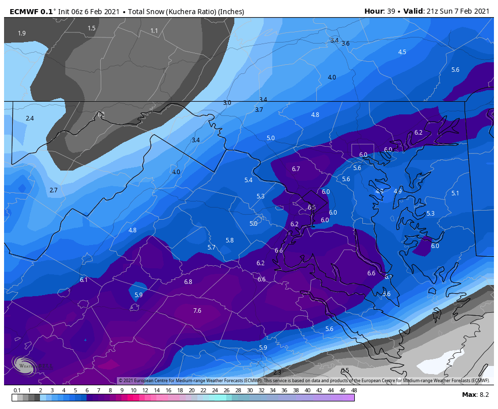
Really nice run for the southern part of our area. Looks like a good hit for DC. I don’t mind the south shift to give us in DC some breathing room for eventual shifts north.
-
I thought at 42 the shortwave looked less intense than 18z...