

batmanbrad
-
Posts
220 -
Joined
-
Last visited
Content Type
Profiles
Blogs
Forums
American Weather
Media Demo
Store
Gallery
Everything posted by batmanbrad
-
Still could upgrade it during the next hour or so, even though it wasn't at 5PM. Has to be right on the cusp now, another MB or two would do it pressure-wise, or anything else to support increase.
-
100mph as of the new 2PM intermediate advisory!
-
2020 Mid-Atlantic Severe Weather - General Thread
batmanbrad replied to Kmlwx's topic in Mid Atlantic
looks like a new cell popping near Leesburg, moving ENE -
2020 Mid-Atlantic Severe Weather - General Thread
batmanbrad replied to Kmlwx's topic in Mid Atlantic
Moco just got warned, also with "possible tornado" language, line from the west looks to be holding together for now. -
2020 Mid-Atlantic Severe Weather - General Thread
batmanbrad replied to Kmlwx's topic in Mid Atlantic
"Tornado Possible" wording is in the STW message for the Frederick area storm... -
and if you want the spaghetti with those meatballs, check out www.spaghettimodels.com
-
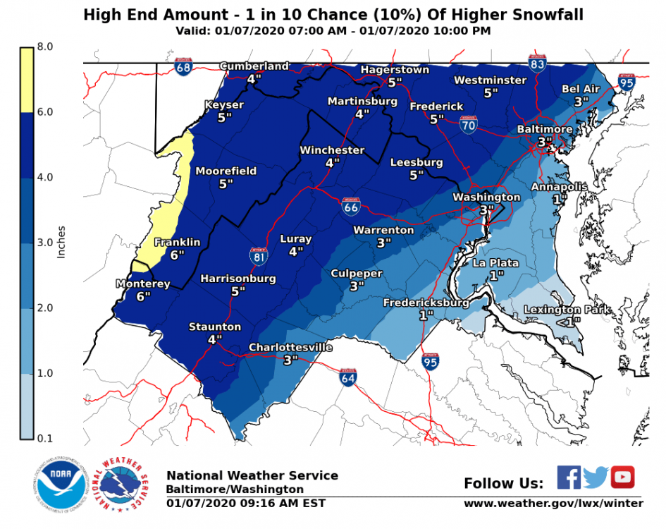
Only 10% chance, says NWS (recently updated snow maps), but we can dream of 5" up here in Laytonsville area...
-
our pity/puny/pathetic/whatever MD just issued... guaranteeing nada for our CWA: https://www.spc.noaa.gov/products/md/md1811.html
-
2019 Mid-Atlantic Severe Wx - General Discussion
batmanbrad replied to Kmlwx's topic in Mid Atlantic
Guess they're all waiting for MOD risk upgrade? Seriously, I agree - we don't get too many ENH risks (especially 1+ days in advance), this D2 outlook even mentions a TOR possibility if enough destabilization occurs. Could be an interesting Tuesday.- 2,802 replies
-
- 1
-

-
- severe
- thunderstorms
- (and 4 more)
-
Yup, now central Moco under a flood warning. Soon we will be "flooded with warnings" (if we haven't been already)
-
yeah, typical - but there could be some training/backbuilding going on to the SW so we might not be done yet... more room for further disappointments?
-
yes, lightningmaps.org confirms increasing activity still west of I270 between Germantown and Potomac...
-
watching radar, I have a cell to my north (I'm near Laytonsville) and one approaching from my SW that seems to be gaining size/strength, gonna to be hard to avoid me completely at this rate.
-
STW just issued for central MoCo for the storm near Lowes Island/Great Falls area, moving NE at 25mph
-
2019 Mid-Atlantic Severe Wx - General Discussion
batmanbrad replied to Kmlwx's topic in Mid Atlantic
watching the cell that was in Damascus (warned) approaching me from the north, may need a bit of a right turn to avoid missing me to the east (I'm just west of Laytonsville) -
2019 Mid-Atlantic Severe Wx - General Discussion
batmanbrad replied to Kmlwx's topic in Mid Atlantic
yes can see some purple on the COD radar from that cell, quite impressive for that area - looks like it will stay south of the NYC area if it stays on its East heading... -
2019 Mid-Atlantic Severe Wx - General Discussion
batmanbrad replied to Kmlwx's topic in Mid Atlantic
TOR warning issued for that cell about 5 min. ago - also mentions 2" hail possible -
2019 Mid-Atlantic Severe Wx - General Discussion
batmanbrad replied to Kmlwx's topic in Mid Atlantic
you don't often see potential for baseball size hail in this part of the country... this warning's got TOR potential included in it as well. Severe Thunderstorm Warning PAC005-019-031-121-281945- /O.NEW.KPBZ.SV.W.0071.190528T1854Z-190528T1945Z/ BULLETIN - EAS ACTIVATION REQUESTED Severe Thunderstorm Warning National Weather Service Pittsburgh PA 254 PM EDT Tue May 28 2019 The National Weather Service in Pittsburgh has issued a * Severe Thunderstorm Warning for... Southwestern Venango County in northwestern Pennsylvania... Northeastern Butler County in west central Pennsylvania... Northwestern Armstrong County in west central Pennsylvania... Southwestern Clarion County in west central Pennsylvania... * Until 345 PM EDT. * At 253 PM EDT, a severe thunderstorm was located 9 miles southwest of Sugarcreek, or 9 miles southwest of Franklin, moving southeast at 35 mph. This is a very dangerous storm. HAZARD...Destructive, baseball-size hail and wind gusts to 70 mph. SOURCE...Radar. IMPACT...People and animals outdoors will be severely injured. Expect shattered windows, extensive damage to roofs, siding, and vehicles. * Locations impacted include... Knox... Parker... Sligo... Emlenton... Clintonville... St. Petersburg... Eau Claire... Kennerdell... Callensburg... Foxburg... Cherry Valley... Cranberry Township... This includes Interstate 80 in Pennsylvania between mile markers 34 and 57. PRECAUTIONARY/PREPAREDNESS ACTIONS... Tornadoes can develop unexpectedly from severe thunderstorms. If a tornado is reported, move to a basement or small, central room in a sturdy structure. Large hail has been reported! Seek shelter indoors immediately and stay away from windows! This storm has a history of producing damaging wind gusts. Move indoors immediately and stay away from windows! Please report severe weather by calling 412-262-1988, posting to the NWS Pittsburgh Facebook page, or using Twitter @NWSPITTSBURGH. && A Tornado Watch remains in effect until 1000 PM EDT for northwestern and west central Pennsylvania. LAT...LON 4130 7948 4111 7947 4103 7957 4124 7997 4129 8000 4133 8000 4135 7998 TIME...MOT...LOC 1853Z 301DEG 31KT 4130 7996 TORNADO...POSSIBLE HAIL...2.75IN WIND...70MPH $$- 2,802 replies
-
- 1
-
-
- severe
- thunderstorms
- (and 4 more)
-
2019 Mid-Atlantic Severe Wx - General Discussion
batmanbrad replied to Kmlwx's topic in Mid Atlantic
looking at lightningmaps.org, plenty of activity especially around the Urbana area and west of Clarksburg just now... -
2019 Mid-Atlantic Severe Wx - General Discussion
batmanbrad replied to Kmlwx's topic in Mid Atlantic
no more TOR in MoCo: Severe Weather Statement National Weather Service Baltimore MD/Washington DC 258 PM EDT Fri Apr 26 2019 MDC031-261908- /O.CAN.KLWX.TO.W.0016.000000T0000Z-190426T1915Z/ Montgomery MD- 258 PM EDT Fri Apr 26 2019 ...THE TORNADO WARNING FOR SOUTHEASTERN MONTGOMERY COUNTY IS CANCELLED... The storm which prompted the warning has weakened below severe limits, and no longer appears capable of producing a tornado. Therefore, the warning has been cancelled. A Tornado Watch remains in effect until 900 PM EDT for central Maryland. LAT...LON 3911 7697 3902 7720 3906 7723 3923 7711 TIME...MOT...LOC 1855Z 237DEG 33KT 3910 7711 $$ SMZ -
2019 Mid-Atlantic Severe Wx - General Discussion
batmanbrad replied to Kmlwx's topic in Mid Atlantic
Looks like Sterling's MIC did this update... BULLETIN - IMMEDIATE BROADCAST REQUESTED Severe Thunderstorm Warning National Weather Service Baltimore MD/Washington DC 841 PM EDT Fri Apr 19 2019 The National Weather Service in Sterling Virginia has issued a * Severe Thunderstorm Warning for... Western Montgomery County in central Maryland... South central Frederick County in north central Maryland... Eastern Loudoun County in northern Virginia... The City of Fairfax in northern Virginia... Northwestern Fairfax County in northern Virginia... Northeastern Prince William County in northern Virginia... * Until 915 PM EDT. * At 840 PM EDT, severe thunderstorms were located along a line extending from near Arcola to 6 miles northwest of Dale City, moving north at 45 mph. HAZARD...60 mph wind gusts. SOURCE...Radar indicated. IMPACT...Damaging winds will cause some trees and large branches to fall. This could injure those outdoors, as well as damage homes and vehicles. Roadways may become blocked by downed trees. Localized power outages are possible. Unsecured light objects may become projectiles. * Locations impacted include... Germantown, Centreville, Rockville, Gaithersburg, Reston, Leesburg, South Riding, Herndon, Fairfax, Vienna, Broadlands, Lansdowne, Lowes Island, Brambleton, Poolesville, Dulles International Airport, Potomac, Ashburn, Oakton and Montgomery Village. PRECAUTIONARY/PREPAREDNESS ACTIONS... A Tornado Watch remains in effect until midnight EDT for central and north central Maryland...and northern Virginia. Remain alert for a possible tornado! Tornadoes can develop quickly from severe thunderstorms. If you spot a tornado go at once into the basement or small central room in a sturdy structure. && LAT...LON 3931 7745 3916 7711 3872 7735 3895 7763 TIME...MOT...LOC 0040Z 200DEG 41KT 3893 7758 3872 7742 TORNADO...POSSIBLE HAIL...<.75IN WIND...60MPH $$ LEE -
2019 Mid-Atlantic Severe Wx - General Discussion
batmanbrad replied to Kmlwx's topic in Mid Atlantic
looks like a bit of a bow echo signature down to the southwest... could get interesting here in MoCo pretty soon - severe thunderstorm warning just went up according to my phone -
Will we get to see that time-lapse footage you mentioned you'd set up for this storm? That'll be cool to watch with such a long duration but placid (wind-wise) storm...
-
good discussion of how this storm formed/evolved by CWG: https://www.washingtonpost.com/weather/2019/01/14/first-snowstorm-packs-wallop-how-much-snow-fell-how-it-happened/?utm_term=.54287740f8da
-
unfortunately no board to take good measurements with, but I did find somewhere between 5-6" for the first wave and 7+ inches just now with snow nearly stopped here in Gaithersburg (NE side, near Laytonsville). So, around a foot, probably with some compaction especially with wave 1. Sure was easy to shovel the 2nd wave, SO light and fluffy! Now will wait for my cul-de-sac to be plowed out...
