batmanbrad
-
Posts
220 -
Joined
-
Last visited
Content Type
Profiles
Blogs
Forums
American Weather
Media Demo
Store
Gallery
Everything posted by batmanbrad
-
URGENT - WINTER WEATHER MESSAGE National Weather Service Baltimore MD/Washington DC 250 PM EST Tue Feb 16 2021 DCZ001-MDZ005-006-008-011-013-014-016-503>508-VAZ052>054-506- 170400- /O.EXB.KLWX.WS.A.0008.210218T0800Z-210219T1100Z/ District of Columbia-Carroll-Northern Baltimore-Cecil- Southern Baltimore-Prince Georges-Anne Arundel-Charles- Northwest Montgomery-Central and Southeast Montgomery- Northwest Howard-Central and Southeast Howard-Northwest Harford- Southeast Harford-Prince William/Manassas/Manassas Park-Fairfax- Arlington/Falls Church/Alexandria-Eastern Loudoun- 250 PM EST Tue Feb 16 2021 ...WINTER STORM WATCH IN EFFECT FROM LATE WEDNESDAY NIGHT THROUGH LATE THURSDAY NIGHT... * WHAT...Total snow accumulations of 5 or more inches and total ice accumulations of a quarter inch or more are possible. * WHERE...The Washington, Baltimore, and Fredericksburg Metropolitan areas. * WHEN...From late Wednesday night through late Thursday night. * IMPACTS...Power outages and tree damage are likely due to the ice. Travel could be nearly impossible. The hazardous conditions could impact the morning or evening commute. PRECAUTIONARY/PREPAREDNESS ACTIONS... Monitor the latest forecasts for updates on this situation. && $$
-
compromise... business casual?
-
Jan 31st - 33rd Storm Obs and Disco like it's 1979
batmanbrad replied to Bob Chill's topic in Mid Atlantic
I was over in Germantown mid afternoon (getting some takeout lunch from Carrabbas) and the sun was out... briefly. Then soon back into the snow. But it was good to see sunshine if only for a few minutes. -
Jan 31st - 33rd Storm Obs and Disco like it's 1979
batmanbrad replied to Bob Chill's topic in Mid Atlantic
I briefly read that as AL Sleet (your hippy dippy weatherman, thank you George Carlin! -
Jan 31st - 33rd Storm Obs and Disco like it's 1979
batmanbrad replied to Bob Chill's topic in Mid Atlantic
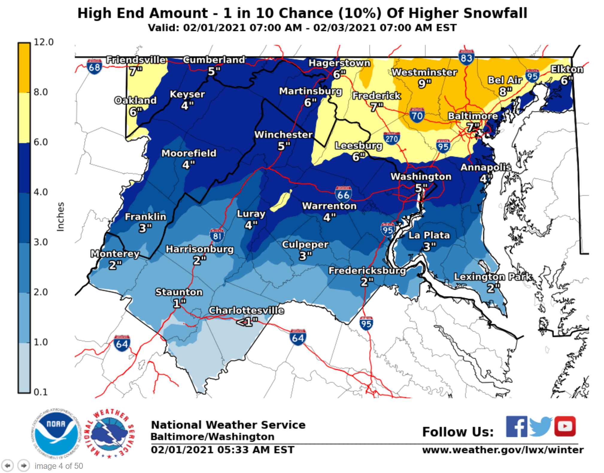
Indeed, just NE of me (I'm in Gaithersburg/Laytonsville area) 8-9" is "possible":
-
Jan 31st - 33rd Storm Obs and Disco like it's 1979
batmanbrad replied to Bob Chill's topic in Mid Atlantic
of note is that they have also upped the "high end amount/10% chance" map, potential of over a foot in places just N and W of DC: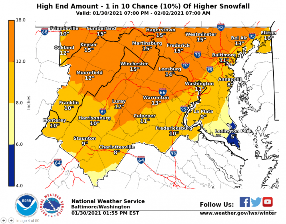
-
Or to borrow from ELP... Welcome back my Chill friend to the show that never ends...
-
In honor of the return of THE CHILL, I think we should name this upcoming storm for him in some way? Or might it depend on how it performs...
-
would think after these 12Z runs, LWX should be bumping up the threat from ENH to MOD soon?
-
looks like at 144 it's just outside the 40/70 benchmark off the MA coast, that should be ideal for much of SE New England? But, moving fast at that point so their window of precip will be much shorter than ours down here. Down to 984 there - would imagine they'd get some serious wind up there too.
-
December 16-17, 2020 Winter Storm Obs/Nowcasting
batmanbrad replied to WxUSAF's topic in Mid Atlantic
CC line seems to be right along I-66 currently - slowly but steadily moving north. -
December 16-17, 2020 Winter Storm Obs/Nowcasting
batmanbrad replied to WxUSAF's topic in Mid Atlantic
Pretty heavy snow here in Gaithersburg (close to Laytonsville), those who said we might be able to benefit from the front end thump were right - hope the HRRR is correct and we can get a couple more hours of this beautiful stuff before the changeover later this afternoon, and maybe we can get a dessert later tonight from the back end. -
December 16-17, 2020 Winter Storm Obs/Nowcasting
batmanbrad replied to WxUSAF's topic in Mid Atlantic
latest GFS says congrats State College/Williamsport with their 2+ feet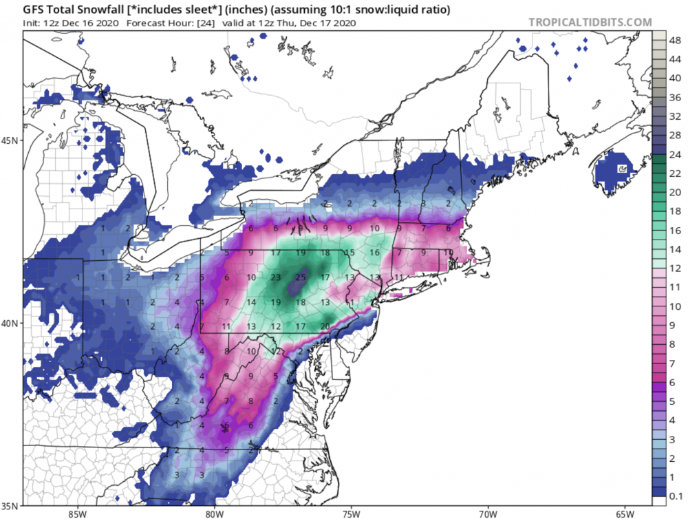
-
thanks - I deleted my post after I saw I was beaten to it (ninja'd?) by jaydreb, LOL... also saw that 20 of that 29" spot occurs in 6 hours between 66 and 72, LOL
-
yes, this is that same Jeff: https://ges.umbc.edu/halverson/
-
looks like at 72 the SLP has jumped east some, that should help the I95 folks this run
-
Don't know if this was mentioned earlier (I couldn't find a reference), but earlier this evening, Capital Weather Gang did a Facebook Live presentation featuring Jason Samenow, Jeff Halverson, and AmWx's own Wes Junker (usedtobe)... check it out! I wasn't sure if I could/should post a link to it, but if you do a search on FB for CWG, you should be able to find and view it.
-
award for 2nd place goes to P22, with honorable mentions to P17 and P03, and (almost) P26.
-
HP in Canada 2mb stronger at 96 and slightly SW of previous run, while SLP is closer to the DE coast but still offshore enough, to my novice eyes. All seem to be good signs.
-
true... question is whether being bullish is/will be good for the other "R" (Reputation)
-
evidently TWC hasn't factored in the 12Z model runs yet... let's see how long before they do.
-
12Z GEM pulls the low into southern DE @ 84, clear west shift which isn't good for I95 corridor
-
Canadian up next, would love to see it improve at least as much as the 12Z GFS!
-
that HP shifted east some at 90 on the 18Z GFS, probably not the trend we want to see?
-
or do we get to CRAS (doesn't a reference to that model belong somewhere on the bingo board?) in now?