batmanbrad
-
Posts
220 -
Joined
-
Last visited
Content Type
Profiles
Blogs
Forums
American Weather
Media Demo
Store
Gallery
Everything posted by batmanbrad
-
2022 Mid-Atlantic Severe Wx Thread (General Discussion Etc)
batmanbrad replied to Kmlwx's topic in Mid Atlantic
WPC on board with flood potential tomorrow: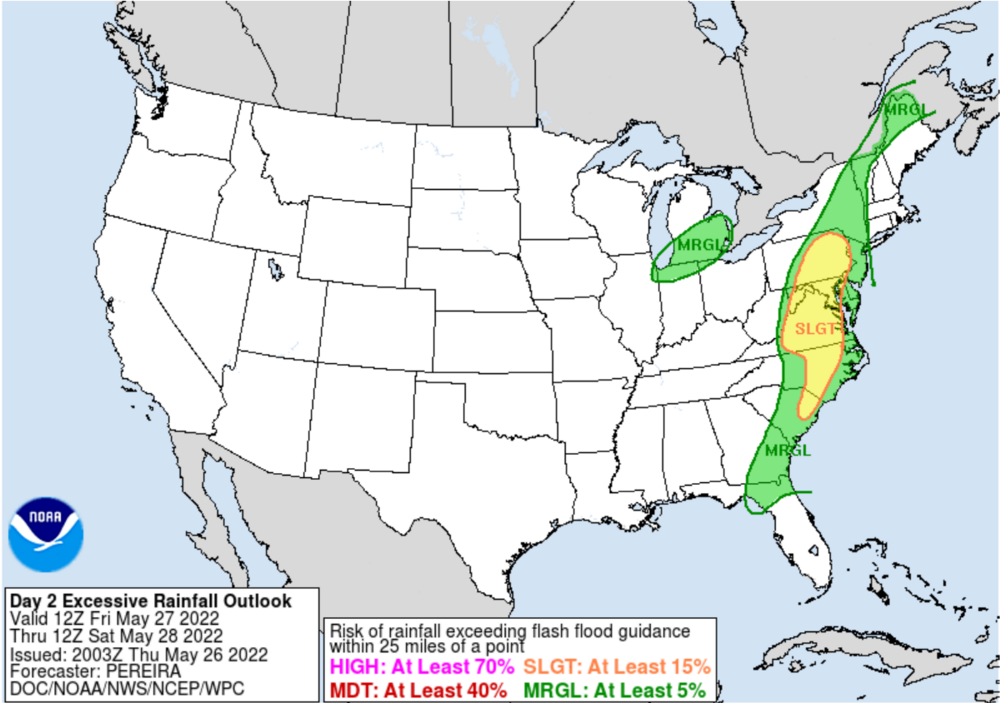
-
2022 Mid-Atlantic Severe Wx Thread (General Discussion Etc)
batmanbrad replied to Kmlwx's topic in Mid Atlantic
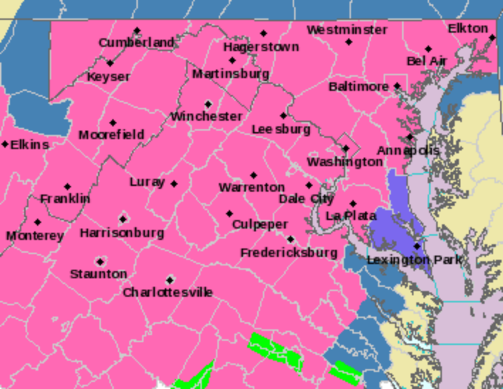
that is a huge watch box!
-
January 28-29, 2022 Miller abcdefu Storm Threat
batmanbrad replied to WxUSAF's topic in Mid Atlantic
I know this is not the New England section, but if anybody wants to see a very long technical discussion about the storm's potential impacts for up that way (especially eastern MA and RI), check out the afternoon AFD from BOX. My sister lives up in the Boston burbs and it looks like they will really get whacked there. Some pretty impressive totals being painted, plus serious wind/power outage potential - all this without much if any blocking! -
January 28-29, 2022 Miller abcdefu Storm Threat
batmanbrad replied to WxUSAF's topic in Mid Atlantic
Hopefully not on a Radioshack Trash 80 -
January 28-29, 2022 Miller abcdefu Storm Threat
batmanbrad replied to WxUSAF's topic in Mid Atlantic
With all that blue on that map near Richmond, maybe DT will endorse it? -
don't know if this was posted already but the morning AFD from LWX had this from their forecaster noting possible need to up snow totals: .NEAR TERM /THROUGH TONIGHT/... I performed a cursory analysis of current conditions this morning and I found that temps are running a few degrees cooler than forecast with dewpoints in the single digits. Up stream observations in NC and southern VA suggests that snow is over performing. I have adjusted my snow ratios this morning to account for the well below freezing layer ahead of the precipitation which should allow for higher snow rates. Initial onset of precipitation is on track this morning and snow should fluffy to start before switching over to wet snow as the layer starts to warm and transitions over to a wintry mix for most areas along and east of I-81. I will continue to monitor current conditions to see if I need to up snow totals. It wouldn`t surprise me if we get higher snow totals further eastward than expected due to extremely cool air mass ahead of this system.
-
or he did see it, and decided to toss it.
-
CWG just posted on FB that there should be a briefing on the upcoming storm (probably including Wes again) coming out about 2:30PM.
-
wow 983mb right over NYC at 144, winter 'cane territory there. Stalls a bit then takes off NE again.
-
Looks to my novice eyes that the HP to the north moves too fast out of the way and east, allowing this monster to tuck too far inland?
-
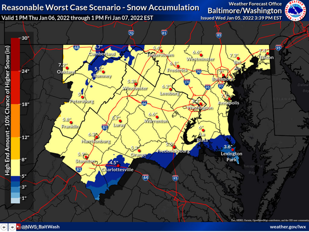
NWS also now has what used to be called something else ("90th percentile")? - now it has another name, but for us I contend this should be called (reasonable) BEST case scenario!
-
If only we could get Randy Newman to sing that...
-
Is that the same Sharpie that was used during Hurricane Dorian's Sharpiegate?
-
2021 Atlantic Hurricane Season Tracking Thread
batmanbrad replied to WxWatcher007's topic in Mid Atlantic
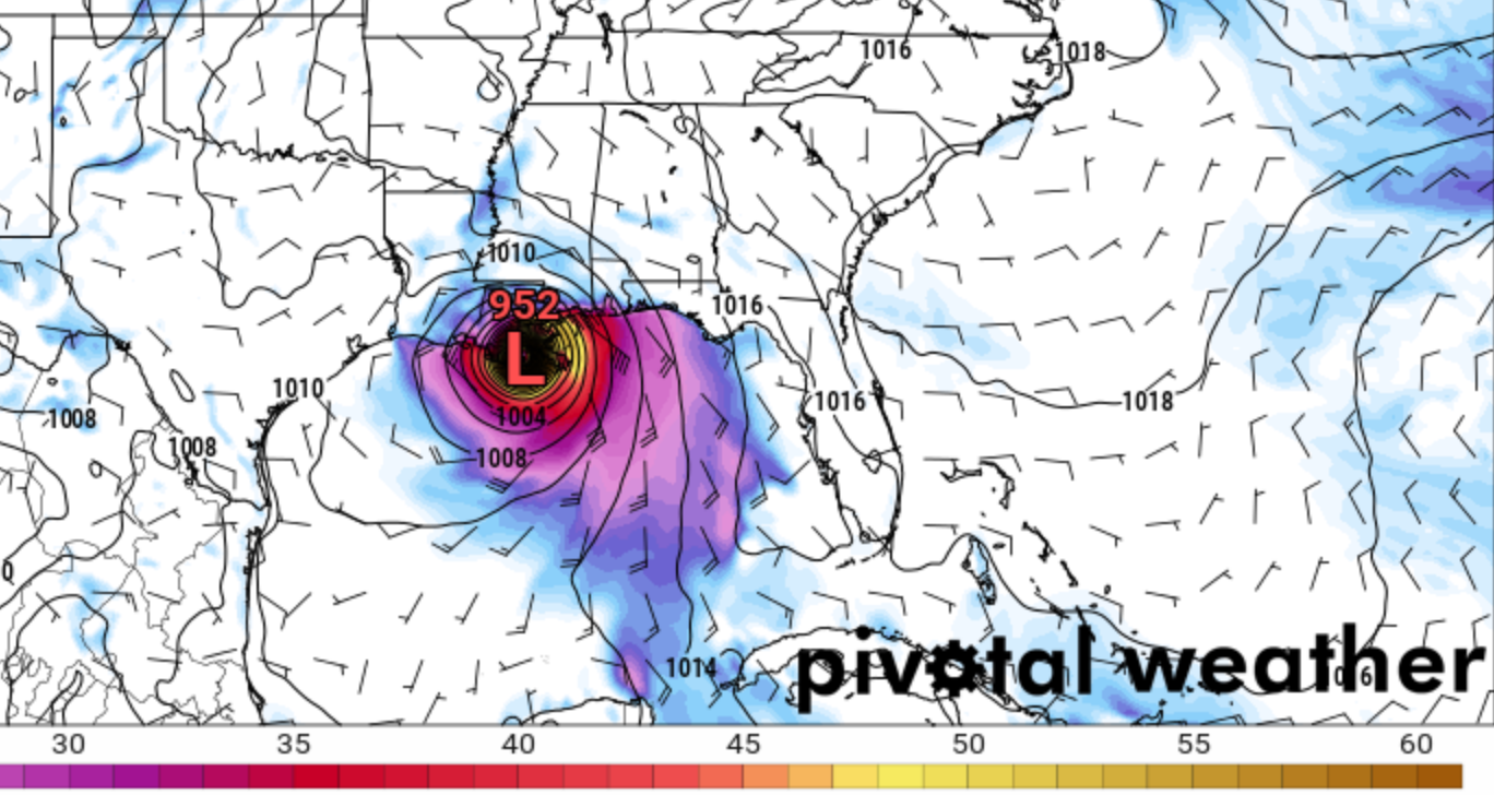
New Orleans area better hope this run doesn't hold: this is the 12Z GFS late afternoon on Sunday:
-
2021 Mid-Atlantic Severe Weather - General Discussion
batmanbrad replied to Kmlwx's topic in Mid Atlantic
MD issued for our northern and western areas: https://www.spc.noaa.gov/products/md/md1388.html Not all that enthusiastic and only a 40% probability, so we'll see what happens but evidently they are not all sure the current cloud cover will break up enough to let the more aggressive scenarios for later this afternoon occur? -
2021 Mid-Atlantic Severe Weather - General Discussion
batmanbrad replied to Kmlwx's topic in Mid Atlantic
you were right, a FFW was issued a short while ago: Flood Watch National Weather Service Baltimore MD/Washington DC 1025 PM EDT Mon Jun 14 2021 DCZ001-MDZ013-014-016-504-VAZ053-054-150600- /O.NEW.KLWX.FF.A.0003.210615T0225Z-210615T0600Z/ /00000.0.ER.000000T0000Z.000000T0000Z.000000T0000Z.OO/ District of Columbia-Prince Georges-Anne Arundel-Charles-Central and Southeast Montgomery-Fairfax-Arlington/Falls Church/Alexandria- Including the cities of Silver Spring, South Gate, Bowie, Arlington, Annapolis, Falls Church, Odenton, Bethesda, Chantilly, Centreville, College Park, Herndon, Severna Park, Greenbelt, McLean, St. Charles, Camp Springs, Rockville, Arnold, Waldorf, Suitland-Silver Hill, Laurel, Severn, Reston, Alexandria, Clinton, Glen Burnie, Washington, Annandale, Gaithersburg, and Franconia 1025 PM EDT Mon Jun 14 2021 ...FLASH FLOOD WATCH IN EFFECT UNTIL 2 AM EDT TUESDAY... The National Weather Service in Sterling Virginia has issued a * Flash Flood Watch for portions of DC...Maryland and northern Virginia, including the following areas: in DC, District of Columbia. In Maryland, Anne Arundel, Central and Southeast Montgomery, Charles and Prince Georges. In northern Virginia, Arlington/Falls Church/Alexandria and Fairfax. * Until 2 AM EDT Tuesday * Thunderstorms with intense rainfall will cause rainfall amounts around 1-2 inches in localized areas within an hour. * Heavy rain in short periods of time will cause the potential for streams and creeks to quickly rise out of their banks as well as the potential for flash flooding in urban areas. PRECAUTIONARY/PREPAREDNESS ACTIONS... A Flash Flood Watch means that conditions may develop that lead to Flash Flooding. Flash Flooding is a very dangerous situation. You should monitor later forecasts and be prepared to take action should Flash Flood Warnings be issued. -
2021 Mid-Atlantic Severe Weather - General Discussion
batmanbrad replied to Kmlwx's topic in Mid Atlantic
Yep, Radarscope shows estimated 2" hail with that cell, but only estimate. -
2021 Mid-Atlantic Severe Weather - General Discussion
batmanbrad replied to Kmlwx's topic in Mid Atlantic
STW just issued for the cell near the Boyds/Germantown area -
2021 Mid-Atlantic Severe Weather - General Discussion
batmanbrad replied to Kmlwx's topic in Mid Atlantic
also to my weenie eyes, there appears to be an outflow boundary starting near the Frederick area cells and going WSW from there, moving SE. Might be aiding in firing up those couple of cells in the FDK area? Could backbuild some ahead of the line further NW. -
2021 Mid-Atlantic Severe Weather - General Discussion
batmanbrad replied to Kmlwx's topic in Mid Atlantic
I'm in the NE edge of Montgomery Village (near Laytonsville), heavy rain but no hail here. More likely down towards Derwood, I'd think. -
2021 Mid-Atlantic Severe Weather - General Discussion
batmanbrad replied to Kmlwx's topic in Mid Atlantic
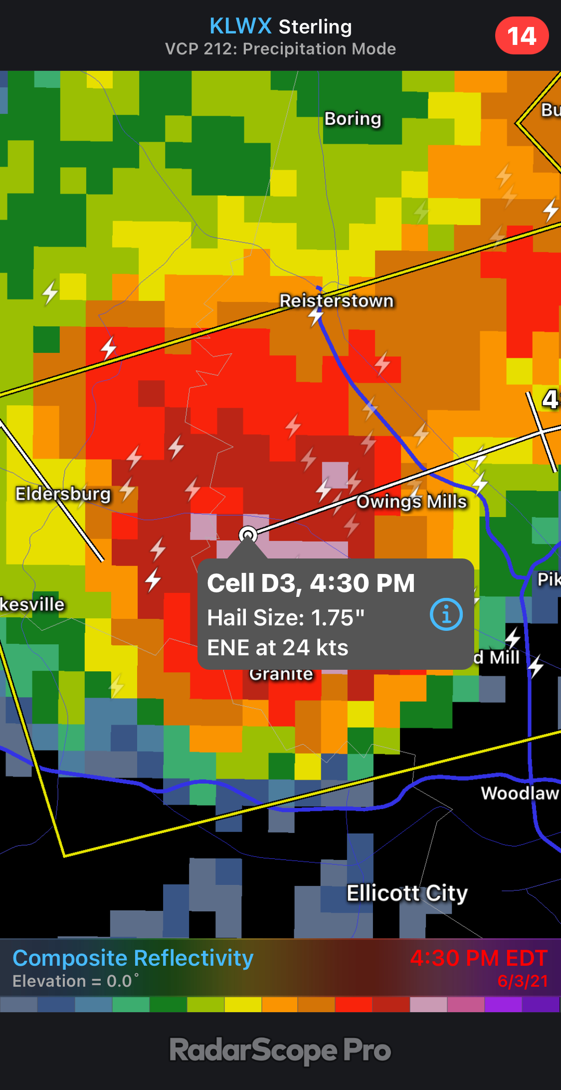
more big hail reported in the cell approaching Owings Mills:
-
2021 Mid-Atlantic Severe Weather - General Discussion
batmanbrad replied to Kmlwx's topic in Mid Atlantic
1.75" hail reported with that cell/line approaching Purcellville -
2021 Mid-Atlantic Severe Weather - General Discussion
batmanbrad replied to Kmlwx's topic in Mid Atlantic
severe thunderstorm watch just came through to my phone for our area (I'm in Gaithersburg) -
* WHAT...Heavy snow along with sleet and freezing rain. Total snow accumulations around 3 to 6 inches with ice accumulation around one to a quarter inch. assume they meant to say "one tenth to a quarter inch"... would hope we don't get anywhere near one inch!
-
now it has... reminds me of the movie "Pretty In Pink"?