batmanbrad
-
Posts
220 -
Joined
-
Last visited
Content Type
Profiles
Blogs
Forums
American Weather
Media Demo
Store
Gallery
Everything posted by batmanbrad
-
oh yes we are. It's just that we're getting 1-2... snowflakes
-
I'm sure Cantore is already trying to figure out where the best thundersnow chances are... or maybe he'll just go out to Nags Head think there'll be a late 'cane around there next week and get caught in a snowstorm instead that will miss our area and dump down that way.
-
Is it coincidence (or not) that you mention "hopefully this time we score" and "the Pamela Anderson bust" in the same message? Speaking of DT, his latest Twitter posts feature a lot of WOOFing over the 12/23 threat...
-
So from this map, instead of the DC Snow Hole, we have the FairfaxCo/MoCo/HoCo/Baltimore ZR Hole!
-
yes, if I'm in the Tampa/Clearwater/St Pete area I'm not liking this run, if it jogs slightly more east that area will be in the worst area (RFQ) of the cane.
-
the short trip over the western part of Cuba certainly had little negative affect on the system, not a good sign for wherever in the Gulf it heads for.
-
looking at Pivotal, on the Euro hi-res, system at 00Z on 9/27 is already 12mb stronger compared with the same timeframe on the 0Z run (990mb vs. 1002mb) edit: also moving faster than the 00Z run, approaching the western tip of Cuba already as of 9/27 06Z on the latest euro hires run.
-
2022 Mid-Atlantic Severe Wx Thread (General Discussion Etc)
batmanbrad replied to Kmlwx's topic in Mid Atlantic
so what are the odds of a pity MD (a MD for Md., ha!) in the next hour or so? -
2022 Mid-Atlantic Severe Wx Thread (General Discussion Etc)
batmanbrad replied to Kmlwx's topic in Mid Atlantic
looks like a little bit of training cell stuff setting up WSW to ENE heading in the general direction of MoCo, not sure if it will maintain itself, but if it fills in/enhances, the flood threat could develop. -
2022 Mid-Atlantic Severe Wx Thread (General Discussion Etc)
batmanbrad replied to Kmlwx's topic in Mid Atlantic
yeah sitting here near Laytonsville wondering what the storms near Poolesville heading for the Germantown area are going to do when they intersect those outflow boundaries nearby. -
2022 Mid-Atlantic Severe Wx Thread (General Discussion Etc)
batmanbrad replied to Kmlwx's topic in Mid Atlantic
Looks like that southward-moving outflow boundary generated by the earlier storms north o f I-70 has or is about to reach me here in the area between Gaithersburg/Montgomery Village and Laytonsville, per COD radar loop. Wondering like others whether the approaching storm line from the west will have a chance to interact with it. -
2022 Mid-Atlantic Severe Wx Thread (General Discussion Etc)
batmanbrad replied to Kmlwx's topic in Mid Atlantic
Yes, Andy "Woody!" Woodcock, he was a trip. I occasionally go to other WFO's to check out their AFD's - some can get very wordy/technical, I especially remember the Taunton (now Boston/Norton) office when there would be a coastal storm in winter or a tropical system in summer, the discussion was a bit like "War and Peace"! -
2022 Mid-Atlantic Severe Wx Thread (General Discussion Etc)
batmanbrad replied to Kmlwx's topic in Mid Atlantic
According to https://www.allacronyms.com/ARI/weather_forecast ARI stands for Accelerated Research Institute -
2022 Mid-Atlantic Severe Wx Thread (General Discussion Etc)
batmanbrad replied to Kmlwx's topic in Mid Atlantic
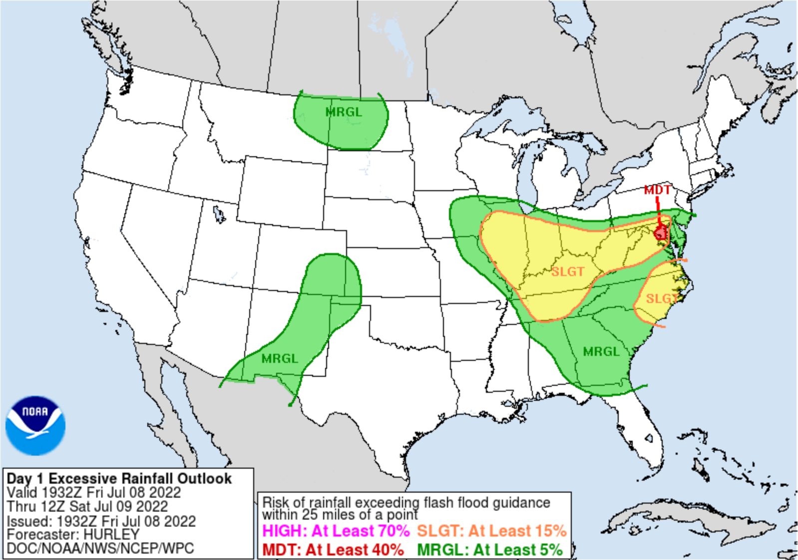
WPC just placed a tiny bullseye of moderate risk for excessive rainfall right over the DC metro area: ...Ohio Valley, Central Appalachians, Mid-Atlantic 1930 UTC Update -- Per collaboration with WFO LWX, have hoisted a Moderate Risk area over parts of the Balt-Wash area for more widespread convection later tonight and into tomorrow morning (early portion of the Day 2 ERO period). There continues to be a multi-model heavy rainfall signal, especially from the CAMs, though the 18Z HRRR has broken a bit from the consensus by now showing the max QPF footprint a little farther south into Southern MD and the Northern Neck of VA. Will continue to keep an eye on observational and mesoanalysis trends this evening; for now have aligned the Moderate Risk area up with the general multi-model consensus, which also incorporates the more elevated 1 and 3 hour QPF exceedance probabilities per the 12Z HREF.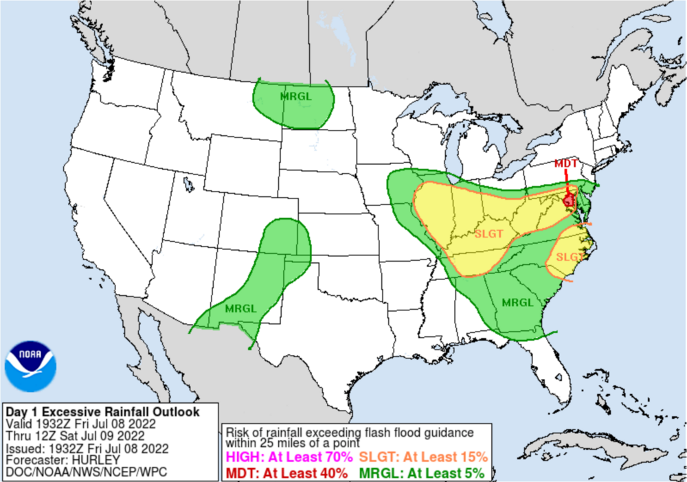
-
2022 Mid-Atlantic Severe Wx Thread (General Discussion Etc)
batmanbrad replied to Kmlwx's topic in Mid Atlantic
fairly heavy rain and occasional lightning/thunder here in Gaithersburg (east side, just west of Laytonsville). Definitely looks like some of this recent development here in mid county could be due to interactions with some of those outflow boundaries that dropped south from the earlier storms near Frederick/I-70. -
2022 Mid-Atlantic Severe Wx Thread (General Discussion Etc)
batmanbrad replied to Kmlwx's topic in Mid Atlantic
I'm up here near Laytonsville and I can hear rumbles of thunder - distant/faint, but I hear them nonetheless. Don't see anything close on radar, can those actually be from that cell downcounty? Seems like a rather large distance between it and me. -
2022 Mid-Atlantic Severe Wx Thread (General Discussion Etc)
batmanbrad replied to Kmlwx's topic in Mid Atlantic
cell near Potomac/Rockville has 1.5" hail tag per RadarScope -
2022 Mid-Atlantic Severe Wx Thread (General Discussion Etc)
batmanbrad replied to Kmlwx's topic in Mid Atlantic
And a partridge in a pear tree? -
2022 Mid-Atlantic Severe Wx Thread (General Discussion Etc)
batmanbrad replied to Kmlwx's topic in Mid Atlantic
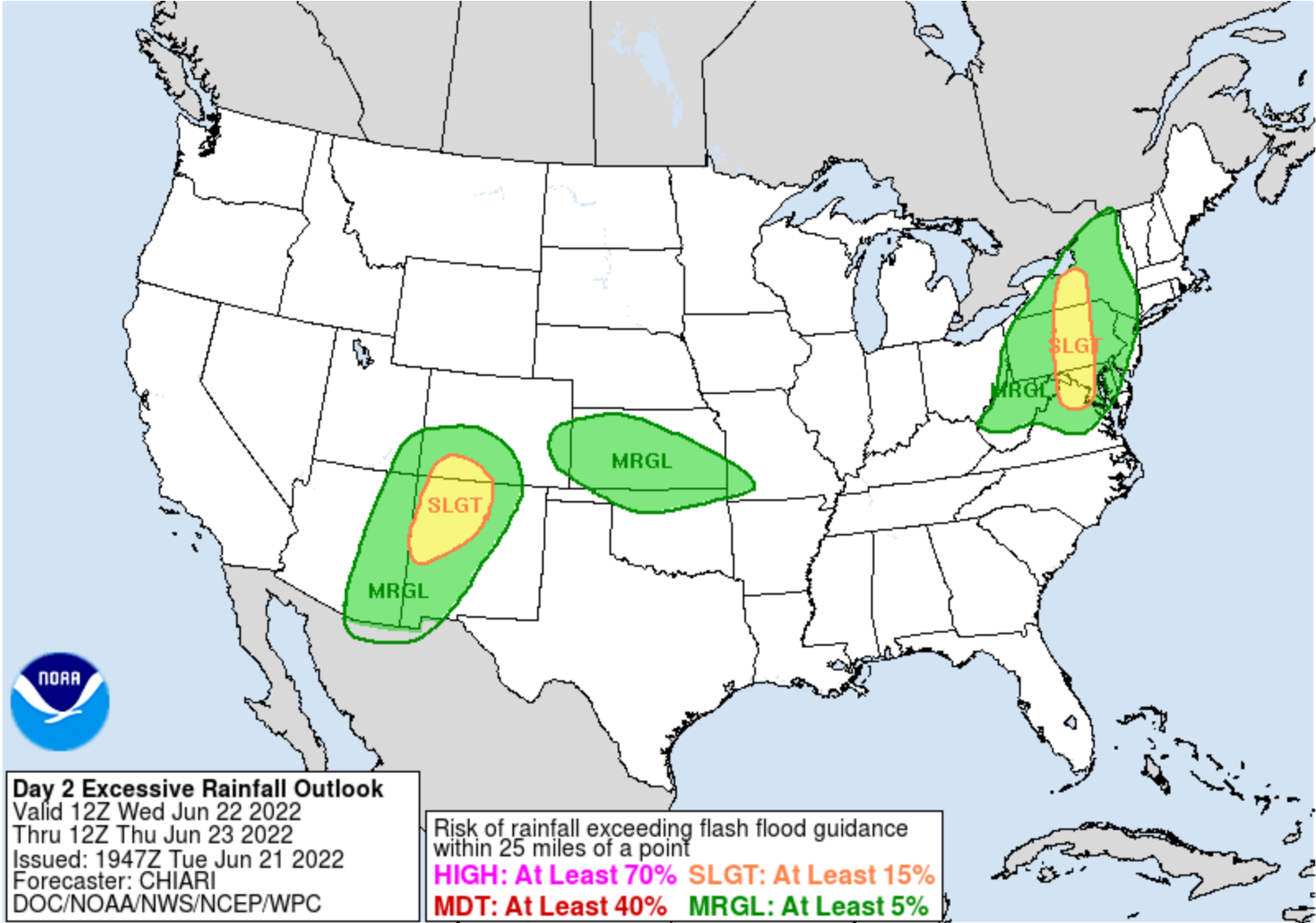
we now have slight risk for both severe wx and flash flooding for tomorrow (the latter per WPC): ...Southern Tier of New York State into the Mid-Atlantic... A slight risk area was added for potential of training convection in a north to south direction along and to the east of the well defined stationary front expected to lie north-south from central New York State, south into central Pennsylvania, central Maryland into northern Virginia. PW values in the vicinity of this front will be in the 1.5 to 2+ standard deviation above the mean range, with hi res model consensus for convection to enhance and potentially train from north to south from Wednesday afternoon into Wednesday evening across these areas. The slight risk area was drawn to best fit the high HREF neighborhood probabilities for 1 and 2"+ amounts in the 1200 UTC Wednesday to 0000 UTC Thursday period, 40-90 and 30-80% respectively. The slight risk was extended a bit farther south of the highest 12 hour probabilities to cover the urban areas from Baltimore to DC.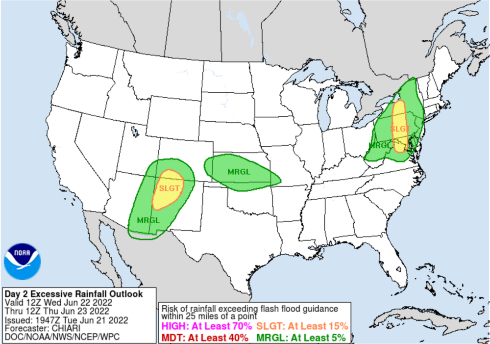
-
2022 Mid-Atlantic Severe Wx Thread (General Discussion Etc)
batmanbrad replied to Kmlwx's topic in Mid Atlantic
the SPC day 1 outlook scheduled to be released at 12:30PM is delayed (by 1/2 hour so far), wonder if that means they are waiting on more model data. -
2022 Mid-Atlantic Severe Wx Thread (General Discussion Etc)
batmanbrad replied to Kmlwx's topic in Mid Atlantic
Radarscope indicates a TVS signature on that LaPlata cell... -
2022 Mid-Atlantic Severe Wx Thread (General Discussion Etc)
batmanbrad replied to Kmlwx's topic in Mid Atlantic
the flood watches recently posted for several counties in MD and VA do indicate that the overnight heavy rain potential should be taken more seriously than the severe wx possibilities... -
2022 Mid-Atlantic Severe Wx Thread (General Discussion Etc)
batmanbrad replied to Kmlwx's topic in Mid Atlantic
sheesh, I don't know this even qualifies for a "pity meso": https://www.spc.noaa.gov/products/md/md1091.html -
2022 Mid-Atlantic Severe Wx Thread (General Discussion Etc)
batmanbrad replied to Kmlwx's topic in Mid Atlantic
That earlier squiggly outflow boundary that was heading north from the earlier storms either has or is about to intersect that Montgomery cell. -
2022 Mid-Atlantic Severe Wx Thread (General Discussion Etc)
batmanbrad replied to Kmlwx's topic in Mid Atlantic
Looks on Radarscope as if that cell is making a bit of a right turn, away from Germantown/Gaithersburg and more towards Derwood/Rockville.