batmanbrad
-
Posts
220 -
Joined
-
Last visited
Content Type
Profiles
Blogs
Forums
American Weather
Media Demo
Store
Gallery
Everything posted by batmanbrad
-
2023 Mid-Atlantic Severe Wx Thread (General Discussion)
batmanbrad replied to Kmlwx's topic in Mid Atlantic
definitely looks like some boundaries are colliding in central MoCo. I'm here close to Laytonsville, skies just opened up and have some pretty solid wind gusts so far. -
2023 Mid-Atlantic Severe Wx Thread (General Discussion)
batmanbrad replied to Kmlwx's topic in Mid Atlantic
MD is out, watch likely: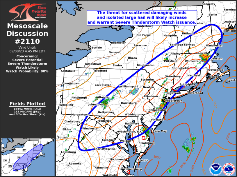
-
2023 Mid-Atlantic Severe Wx Thread (General Discussion)
batmanbrad replied to Kmlwx's topic in Mid Atlantic
some stuff trying to get going in the Chantilly and Fair Oaks areas moving NE that if it holds together could affect more eastern areas of MoCo, but it could also fall apart... -
2023 Mid-Atlantic Severe Wx Thread (General Discussion)
batmanbrad replied to Kmlwx's topic in Mid Atlantic
Yes, looks like even with some outflow boundaries pushing eastward from the Loudoun County storms into MoCo, nothing much firing south and east of a Mt. Airy/Damascus/Germantown line, everything kinda training from SW to NE -
2023 Mid-Atlantic Severe Wx Thread (General Discussion)
batmanbrad replied to Kmlwx's topic in Mid Atlantic
well, even if the wind/hail/tornado potential isn't the greatest for tonight/tomorrow, Sterling thinks highly enough of the heavy rainfall possibilities to issue a flood watch for parts of the area -
2023 Mid-Atlantic Severe Wx Thread (General Discussion)
batmanbrad replied to Kmlwx's topic in Mid Atlantic
does look like they cut back the 5% hail area quite a bit to only western VA and most of WV. -
2023 Mid-Atlantic Severe Wx Thread (General Discussion)
batmanbrad replied to Kmlwx's topic in Mid Atlantic
wowzers! Preliminary Local Storm Report National Weather Service Baltimore MD/Washington DC 746 PM EDT Mon Aug 07 2023 ..TIME... ...EVENT... ...CITY LOCATION... ...LAT.LON... ..DATE... ....MAG.... ..COUNTY LOCATION..ST.. ...SOURCE.... ..REMARKS.. 0422 PM Hail 2 S Staunton 38.13N 79.06W 08/07/2023 M2.50 inch City of Staunton VA Broadcast Media- 2,785 replies
-
- 2
-

-
- severe
- thunderstorms
- (and 3 more)
-
2023 Mid-Atlantic Severe Wx Thread (General Discussion)
batmanbrad replied to Kmlwx's topic in Mid Atlantic
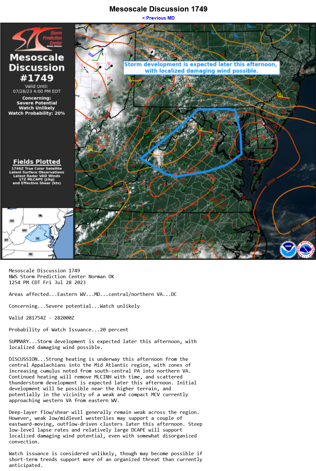
not too much hope for today per pity meso from SPC:
-
2023 Mid-Atlantic Severe Wx Thread (General Discussion)
batmanbrad replied to Kmlwx's topic in Mid Atlantic
https://weather.cod.edu/satrad/nexrad/index.php?type=LWX-N0Q-1-24 can see some semblance of outflow in this loop (at least as of right now, 5:43PM) moving S or SSE from the storms up in Loudoun/Montgomery- 2,785 replies
-
- 2
-
-
- severe
- thunderstorms
- (and 3 more)
-
2023 Mid-Atlantic Severe Wx Thread (General Discussion)
batmanbrad replied to Kmlwx's topic in Mid Atlantic
it's... ALIVE! Everything seems to be congealing from MoCo on west towards the stuff back in Loudoun county. -
2023 Mid-Atlantic Severe Wx Thread (General Discussion)
batmanbrad replied to Kmlwx's topic in Mid Atlantic
the blob is not in any big hurry, if it stays together there will be some decent rainfall totals for those underneath it. Cell movement started out S briefly, has gradually turned left and is now reported as a slight ENE movement, such as it is. Edit: plus there could be a bit of training effect if/when the stuff further west comes though. -
2023 Mid-Atlantic Severe Wx Thread (General Discussion)
batmanbrad replied to Kmlwx's topic in Mid Atlantic
and as Kmlwx predicted, MoCo cell now warned -
2023 Mid-Atlantic Severe Wx Thread (General Discussion)
batmanbrad replied to Kmlwx's topic in Mid Atlantic
TVS sig on it too for now on RadarScope edit: oops, that's TVS for the cell out near Charles Town -
2023 Mid-Atlantic Severe Wx Thread (General Discussion)
batmanbrad replied to Kmlwx's topic in Mid Atlantic
yes quite the red/green couplet of sorts spreading out rapidly, that cell sure developed in a hurry, wonder if some sort of boundry triggered it, but I can't see anything leading up to it that would be an obvious cause. -
2023 Mid-Atlantic Severe Wx Thread (General Discussion)
batmanbrad replied to Kmlwx's topic in Mid Atlantic
cell developing just SE of Pooleville, if it holds together it could impact the Germantown/Gaithersburg/Rockville area. this is out ahead of the main area back towards Winchester so it's not "competing" against anything else for the moment. -
2023 Mid-Atlantic Severe Wx Thread (General Discussion)
batmanbrad replied to Kmlwx's topic in Mid Atlantic
still trying... decent looking cell just popped up quickly in the Rockville area, may or may not have been influenced by a boundary. -
2023 Mid-Atlantic Severe Wx Thread (General Discussion)
batmanbrad replied to Kmlwx's topic in Mid Atlantic
noticed that the SLGT risk area for today was nudged north and east into the immediate DC metro areas on the 9AM morning outlook. Discussion still seemed kind of muted though. -
an occasional small rumble of thunder here and there in Gaithersburg (near Laytonsville), and lots of heavy rain. Guess I can skip the planned lawn watering today.
-
2023 Mid-Atlantic Severe Wx Thread (General Discussion)
batmanbrad replied to Kmlwx's topic in Mid Atlantic
cell developing just to the NE of Laytonsville, moving ENE, just missed me of course. -
2023 Mid-Atlantic Severe Wx Thread (General Discussion)
batmanbrad replied to Kmlwx's topic in Mid Atlantic
satellite loop definitely showing the fairly rapid clearing taking place ahead of the lines of storms out to the west towards Harrisonburg. Still holding out some hope for some action here in Gaithersburg if enough insolation can occur to destabilize us more. -
2023 Mid-Atlantic Severe Wx Thread (General Discussion)
batmanbrad replied to Kmlwx's topic in Mid Atlantic
Per vis loop, the clouds over the mountains to our west appear to be thinning out some, and further west, most of West Virginia looks quite cleared out.- 2,785 replies
-
- 1
-
-
- severe
- thunderstorms
- (and 3 more)
-
Still coming down decently here in the Gaithersburg/Montgomery Village/Laytonsville area... thought it would stop earlier but those waves keep coming up from the south, seeming like some backbuilding of sorts going on. Will eventually move out but for now persistence rules.
-
2023 Mid-Atlantic Severe Wx Thread (General Discussion)
batmanbrad replied to Kmlwx's topic in Mid Atlantic
wow, rather substantial size for this watch box: https://www.spc.noaa.gov/products/watch/ww0159.html -
2023 Mid-Atlantic Severe Wx Thread (General Discussion)
batmanbrad replied to Kmlwx's topic in Mid Atlantic
My phone just gave me a notification of a severe thunderstorm watch being issues for much of the area... this following the meso discussion issued about 1/2 hour ago.- 2,785 replies
-
- 1
-
-
- severe
- thunderstorms
- (and 3 more)
-
or maybe for guessing how much earlier than normal the cherry trees will be in full bloom?