batmanbrad
-
Posts
221 -
Joined
-
Last visited
Content Type
Profiles
Blogs
Forums
American Weather
Media Demo
Store
Gallery
Everything posted by batmanbrad
-
might have been a "false alarm", but I was getting a TVS on the cell NW of Leesburg on RadarScope for a bit, but it seems to have disappeared.
-
I'm sure DT loves this run, both for it being a jack in his area and because he worships the Euro.
-
1/19 - The Roulette Wheel 29 Black Storm - OBS
batmanbrad replied to DDweatherman's topic in Mid Atlantic
looks like a modest band about to cross I-270 in Moco... and perhaps one more moving east of Winchester, that's about it. -
don't forget... Georgetown 0" snow, all rain
-
January Medium/Long Range: A snowy January ahead?
batmanbrad replied to mappy's topic in Mid Atlantic
now ya got me humming "Kind Of A Drag" by the Buckinghams.... LOL. I'm originally from NJ (not as far northwest as Walt is right now) but I skiied a lot in Vermont and New Hampshire and would always read Walt's discussions with mucho interest and enthusiasm especially during winters. -
January Medium/Long Range: A snowy January ahead?
batmanbrad replied to mappy's topic in Mid Atlantic
I bet nobody would have thought the (healthy) storm we are getting tomorrow would potentially serve as an "appetizer" for what the GFS is advertising for next weekend! -
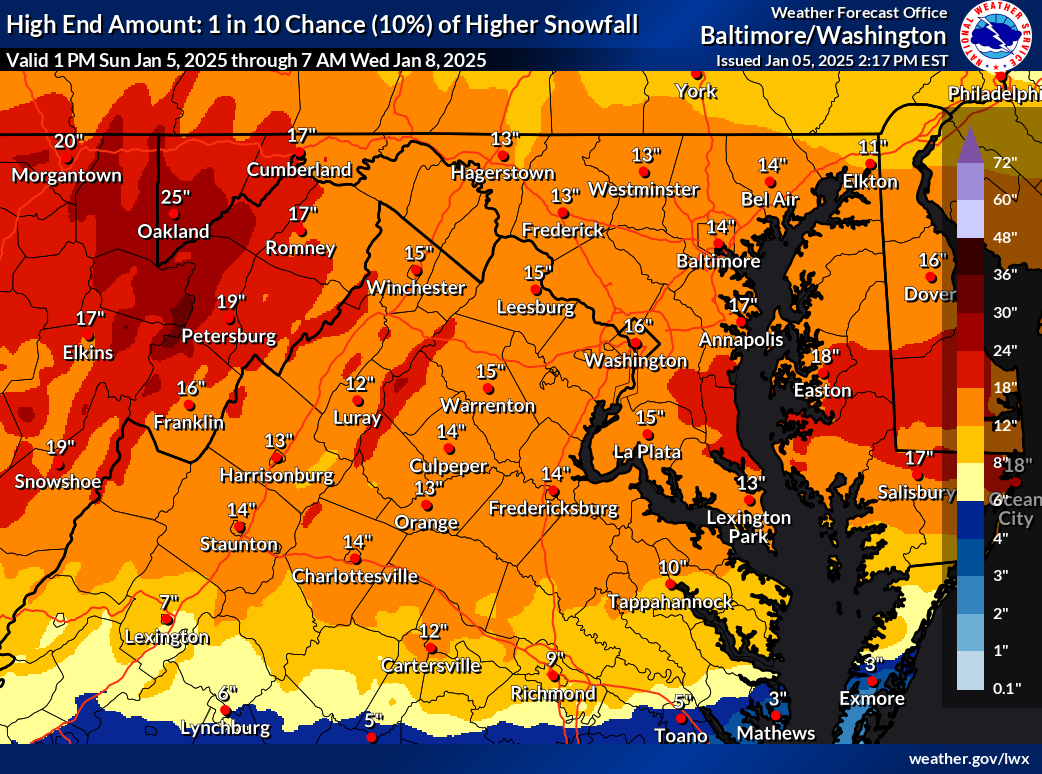
and for all the optimists, here's the corresponding 10% chance map, also has been increased!

-
January: Medium/ Long Range: May the Force be with Us....
batmanbrad replied to Weather Will's topic in Mid Atlantic
along with countless references to the infamous DC Snowhole -
nice fatties near the end of this band coming through Gaithersburg (near Laytonsville)
-
some may have thought this was an underperformer but at the MoCo Airpark they've measured about an inch as of the 2PM obs, and certainly we could squeeze out another 1/4 to 1/2 inch here... since they'd basically been predicting 1-2" areawide today, that seems pretty much on target.
-
radar seems to be showing another line about to (slowly) enter western MoCo soon - maybe not (yet?) quite as potent as the last line that went through recently, but we'll see. Could even have a bit of a training effect as the heavier precip is sliding SW to NE as the line itself gradually pushes east.
-
over 14 inches today so far as of the 9PM observation - likely has or will be setting a daily rainfall record since likely to have heavy rainfall right through midnight, wonder what the record was going into this storm. edit: 17 1/2 inches today as of 10PM
-
ugh the HAFS-B model has this just west of the Tampa area with SLP in the mid-920s on its 12Z run as of early morning Wed. 10/9
-
2024 Atlantic Hurricane Season
batmanbrad replied to Stormchaserchuck1's topic in Tropical Headquarters
18z GFS so far coming in weaker and further south, typical model back-and-forth continues -
small consolation to all the affected areas/population, but this one's a no-brainer - "Helene" will surely be retired so no more systems with that name will happen.
-
Hurricane Helene: Remnants Impact to Mid-Atlantic
batmanbrad replied to WxUSAF's topic in Mid Atlantic
any chance that heavy stuff near and to the west of Richmond might make it up into the DC metro area if it continues to move N or NNE this afternoon? -
I'd say even more than that; previous NHC advisory had LF around Apalachee Bay, now the cone center looks to be around Port St. Joe/Apalachicola area, I'd say 40-50 mile west shift?
-
Dr. Cowan just posted one of his excellent video discussions on the tropical tidbits site, highly recommended. Said he would have another one tomorrow.
-
HWRF (also now using Invest 97) bottoms out around 926mb at hour 78 in the eastern Gulf, heading generally NNE towards Apalachee Bay area. edit: comes ashore near the Apalachee Bay region midday 9/26 in the low/mid 930's
-
TVS signature showing up on Radarscope for that cell a bit SE of Purcelleville
- 1,696 replies
-
- 1
-

-
- severe
- thunderstorms
- (and 5 more)
-
I'm in Gaithersburg (but very close to Laytonsville), have had some good solid downpours for a while though RadarScope seems to tell me the heaviest pixels went to the west/north of me. Stuff seems to be trying to backbuild somewhat down towards the Rockville area so if it keeps training SW to NE we might get more here. Nothing really severe (even though we were warned), some moderate wind but not a whole lot of T&L so far. Edit - actually most of the heavier activity isn't in Rockville, it's east of Poolesville, just north of Darnestown and in parts of Germantown/Gaithersburg, all moving NE. Then it's a break until the next batch out near Front Royal which could get here if it holds together.
-
Tropical Storm Debby: Mid-Atlantic Impacts
batmanbrad replied to WxWatcher007's topic in Mid Atlantic
usually CWG and/or NWS Sterling produces one after the event is over; for now best would be to check the reported totals in the PNS from LWX (last one was updated around 10:30AM this morning so its totals are not yet final, especially since some of the reports are from early in the morning). -
Tropical Storm Debby: Mid-Atlantic Impacts
batmanbrad replied to WxWatcher007's topic in Mid Atlantic
looks like a couplet on the velocity scan, now east of Damascus, heading for Mount Airy area. -
Tropical Storm Debby: Mid-Atlantic Impacts
batmanbrad replied to WxWatcher007's topic in Mid Atlantic
my phone just beeped, TOR warning for central Moco (I'm in NE part of Gaithersburg, near Laytonsville). Heading towards Damascus, says the warning. -
Tropical Storm Debby: Mid-Atlantic Impacts
batmanbrad replied to WxWatcher007's topic in Mid Atlantic
EastCoast NPZ probably figures that green patch of 0.4" over in northern Delaware likely will shift over top of him in the next model runs...