batmanbrad
-
Posts
221 -
Joined
-
Last visited
About batmanbrad

-
might have been a "false alarm", but I was getting a TVS on the cell NW of Leesburg on RadarScope for a bit, but it seems to have disappeared.
-
I'm sure DT loves this run, both for it being a jack in his area and because he worships the Euro.
-
1/19 - The Roulette Wheel 29 Black Storm - OBS
batmanbrad replied to DDweatherman's topic in Mid Atlantic
looks like a modest band about to cross I-270 in Moco... and perhaps one more moving east of Winchester, that's about it. -
don't forget... Georgetown 0" snow, all rain
-
January Medium/Long Range: A snowy January ahead?
batmanbrad replied to mappy's topic in Mid Atlantic
now ya got me humming "Kind Of A Drag" by the Buckinghams.... LOL. I'm originally from NJ (not as far northwest as Walt is right now) but I skiied a lot in Vermont and New Hampshire and would always read Walt's discussions with mucho interest and enthusiasm especially during winters. -
January Medium/Long Range: A snowy January ahead?
batmanbrad replied to mappy's topic in Mid Atlantic
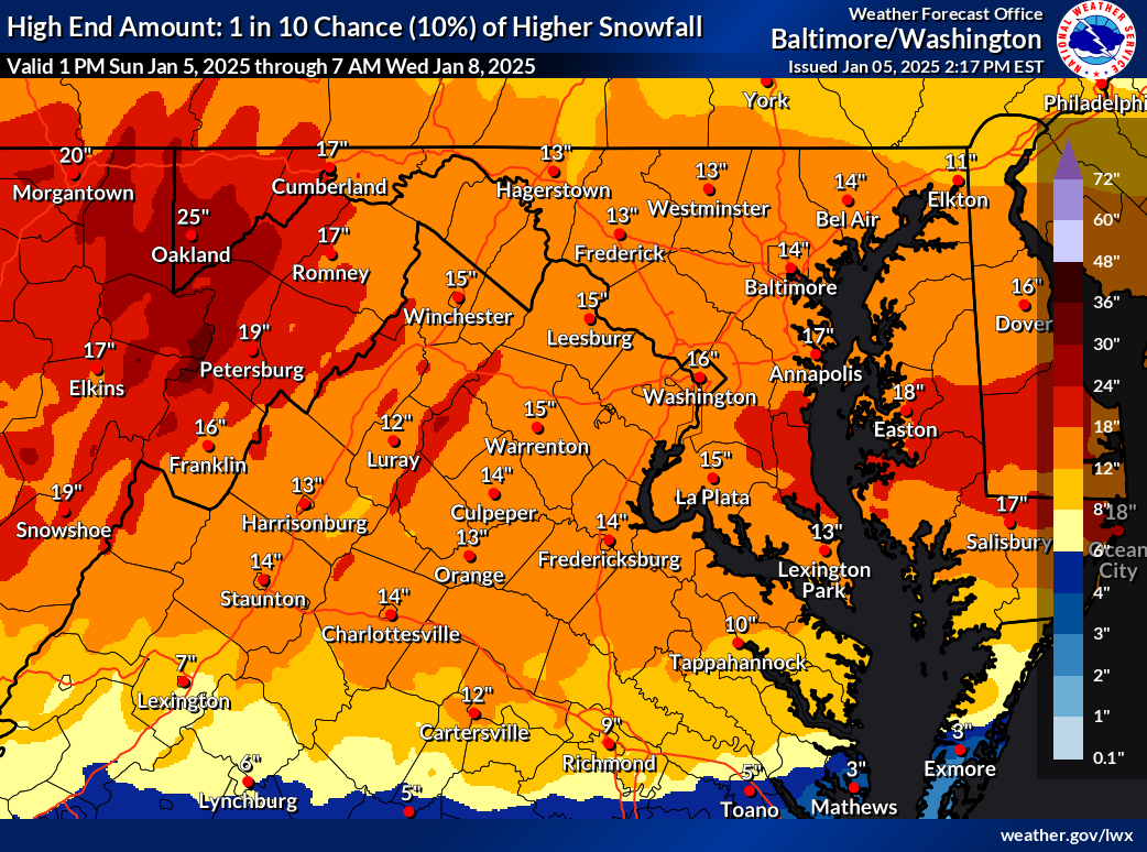
I bet nobody would have thought the (healthy) storm we are getting tomorrow would potentially serve as an "appetizer" for what the GFS is advertising for next weekend! -
and for all the optimists, here's the corresponding 10% chance map, also has been increased!

-
January: Medium/ Long Range: May the Force be with Us....
batmanbrad replied to Weather Will's topic in Mid Atlantic
along with countless references to the infamous DC Snowhole -
nice fatties near the end of this band coming through Gaithersburg (near Laytonsville)
-
some may have thought this was an underperformer but at the MoCo Airpark they've measured about an inch as of the 2PM obs, and certainly we could squeeze out another 1/4 to 1/2 inch here... since they'd basically been predicting 1-2" areawide today, that seems pretty much on target.
-
radar seems to be showing another line about to (slowly) enter western MoCo soon - maybe not (yet?) quite as potent as the last line that went through recently, but we'll see. Could even have a bit of a training effect as the heavier precip is sliding SW to NE as the line itself gradually pushes east.
-
over 14 inches today so far as of the 9PM observation - likely has or will be setting a daily rainfall record since likely to have heavy rainfall right through midnight, wonder what the record was going into this storm. edit: 17 1/2 inches today as of 10PM
-
ugh the HAFS-B model has this just west of the Tampa area with SLP in the mid-920s on its 12Z run as of early morning Wed. 10/9
-
2024 Atlantic Hurricane Season
batmanbrad replied to Stormchaserchuck1's topic in Tropical Headquarters
18z GFS so far coming in weaker and further south, typical model back-and-forth continues -
small consolation to all the affected areas/population, but this one's a no-brainer - "Helene" will surely be retired so no more systems with that name will happen.